


How civic open data can help make us safer
A federal government commitment to open data — epitomized in a White House “datapalooza” last Friday — has catalyzed the development of apps and tools that can help enrich citizens’ lives and help keep them safer.
 We’re no stranger at T4 America to the idea of using open government data to help ordinary citizens better understand their transportation system and how federal and local transportation policy needs to change to make them safer. We’ve regularly used public data from the U.S. Department of Transportation to seed useful tools, like the interactive map of ten years of pedestrian fatalities (Dangerous by Design) that uses the federal traffic fatalities database, or the nationwide map of all U.S. deficient bridges (The Fix We’re In For) sourced from the regular National Bridge Inventory submitted by states to the federal government each year.
The White House followed up their announcement of safety.data.gov earlier in 2012 with a day-long “datapalooza” in Washington, D.C. last week that brought together organizations and developers interested in safety data specifically.
There were some impressive demonstrations of what nonprofits and developers and public agencies have been able to create via public data sets. The real estate company Trulia showed how they’ve used local crime data to add heat maps to home listings or map searches to show how safe a neighborhood is in a city or town, relative to the rest of the city.
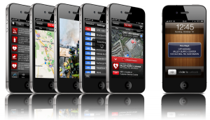
But perhaps the most impressive app on display came in a “the future is here” type of moment. Pulse Point is an app that leverages incredibly valuable-yet-usually-untapped skills dispersed among people all around you (CPR training) to solve the perpetual problem of a limited number of paramedics in a wide area to handle cardiopulmonary crises.
If you have CPR training, you sign up and register yourself and get the PulsePoint app. Partnering with local jurisdictions to make their 911 data available in realtime to the app makes it possible to “dispatch” all nearby CPR-trained people via their smartphone geolocation in the immediate area of someone needing CPR, while paramedics are also concurrently dispatched and en route. For someone in crisis, the 5 minutes between getting CPR from a trained expert at the store next door while waiting for paramedics to arrive could mean the difference between life and death.
It’s a stirring example of the same kind of cooperative sharing that’s made Zipcar and Car2Go and bikesharing and tool co-ops so successful in the last few years, but instead of cars or power drills, people are sharing something so valuable that it can save a life. Needless to say, the PulsePoint presentation received more than a polite round of applause at the end. You could tell that people who hadn’t seen it before were a little stunned.
But what does this have to do with transportation, per se?
Transportation data — and more importantly, having that data organized, accessible and public — is becoming more important than ever as declining transportation revenues have made it more important than ever to measure what we’re spending and see if we’re getting adequate bang for the buck.
MAP-21, the transportation bill passed this summer that goes into effect in just a few days, hopefully represents a transition away from the era of blank checks handed out to states without little accountability for measuring how those dollars get spent. What did they buy? Are we better off after a hundred million dollar project is finished? Is congestion reduced after spending a billion dollars? Are we healthier?
MAP-21 had a lot of references to “performance measures” — though there are still many question marks as to what those performance measures will actually be. But one thing you absolutely must have to measure performance is clear, organized, standardized, and open data. Taxpayers should be able to measure the performance of their transportation spending without having to file open records requests. App developers should be able to easily use available data to provide ever more transparency about decision-making to the very people funding the spending.
Of course, exactly what we decide to measure will have a huge impact on what does and doesn’t get built in the future. What will those performance measures be? What will DOT recommend?
I’m glad you asked. The US Department of Transportation is gathering public input right now on the new MAP-21 performance measures and other metrics with a public, web-based tool that anyone can weigh in with. Their forum closes this Sunday, but if you have the time today, stop by their idea forum for performance measures and offer your two cents. Here are some that we’re supporting and asking our supporters to “vote up”
- A Real Way to Measure Performance
- Separate national bike & ped fatality & injury measures
- Reporting: Clearer standards, better and more accessible data
- Congestion relief: measure people moved by lane
- Don’t ignore the local traffic slowing Interstate freight movement
- Measure accessibility rather than mobility
- Pedestrian & bicycle fatalities/crashes per miles traveled
Our three principles

It’s past time to elevate the national conversation about infrastructure.
Learn more about our platformLatest From The Blog

Meeting the moment after the 2024 elections
Nov 27th, 2024


A pause for TransportationCamp DC
Nov 19th, 2024


I cannot find the zoom link, I registered…
Jan 6th, 2024

A rare look behind the curtain of Transportation…
Jul 28th, 2023

In what Harrison Ford said was his most…
Jul 25th, 2023

Good example, walking to the local taco place…
Jul 24th, 2023

Pingback: How civic open data can help make us safer