
Rays of hope: National City & Southeast San Diego’s Community Connectors story

A group of people representing a range of ages, genders, and ethnicities, stands in a circle beneath a highway overpass, with the sun rising in the background

After many decades of being divided by highways, community members in National City, CA are building capacity to reconnect their community in a project that will also acknowledge their community’s heritage and future.

A group of people representing a range of ages, genders, and ethnicities, stands in a circle beneath a highway overpass, with the sun rising in the background
Community members in National City, CA doing a land acknowledgement ceremony on land they are reclaiming from a highway to a community park. (Mundo Gardens)

The National City Southeast Greenspace Corridor Project is receiving support from the Community Connectors Program, led by Smart Growth America in collaboration with Equitable Cities, the New Urban Mobility Alliance, and America Walks with support from the Robert Wood Johnson Foundation. Learn more about the Community Connectors Program.

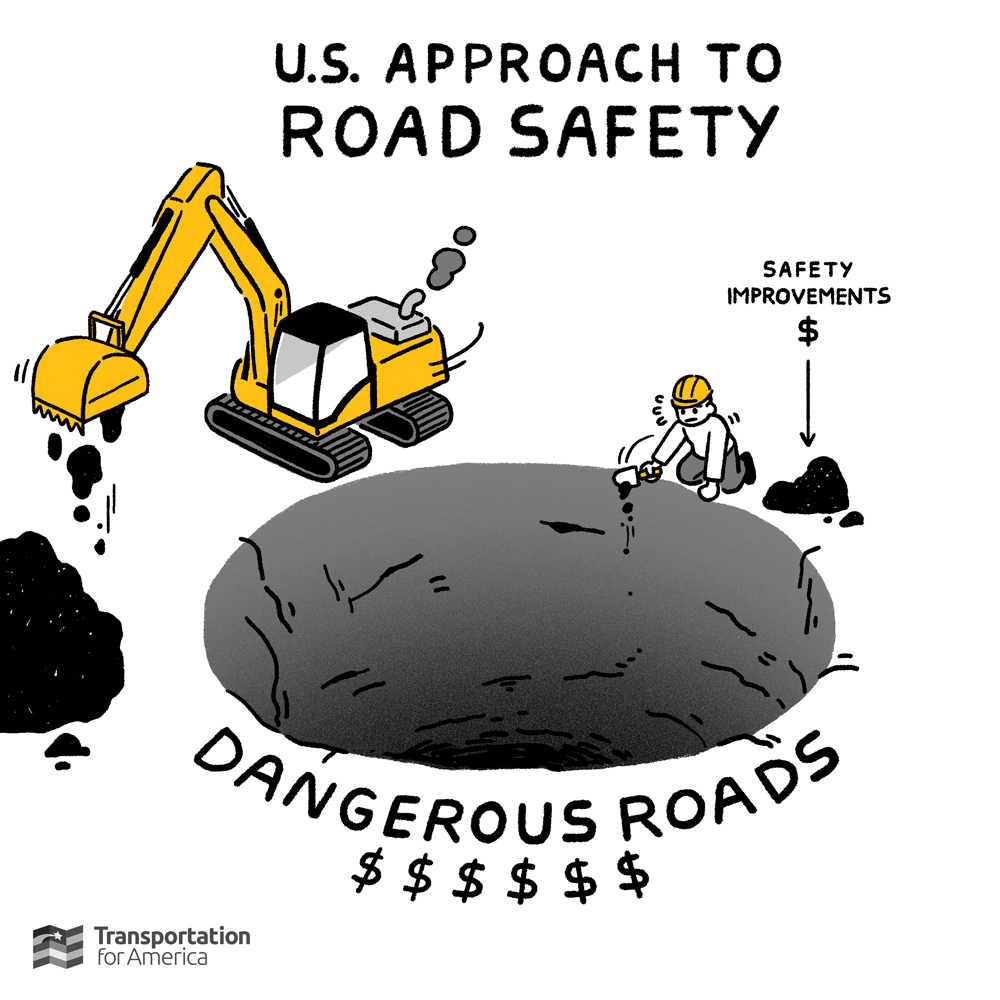
Often romanticized in the media, Southern California has been the home and the template for the modern US highway that we know today. Media portrays these highways as facilitating economic growth and safer and speedier commutes for area residents. However, the underbelly of that media portrayal fails to acknowledge the divisiveness those highways create, separating communities, destroying cultural and economic assets, and exposing many vulnerable road users to deadly conditions.

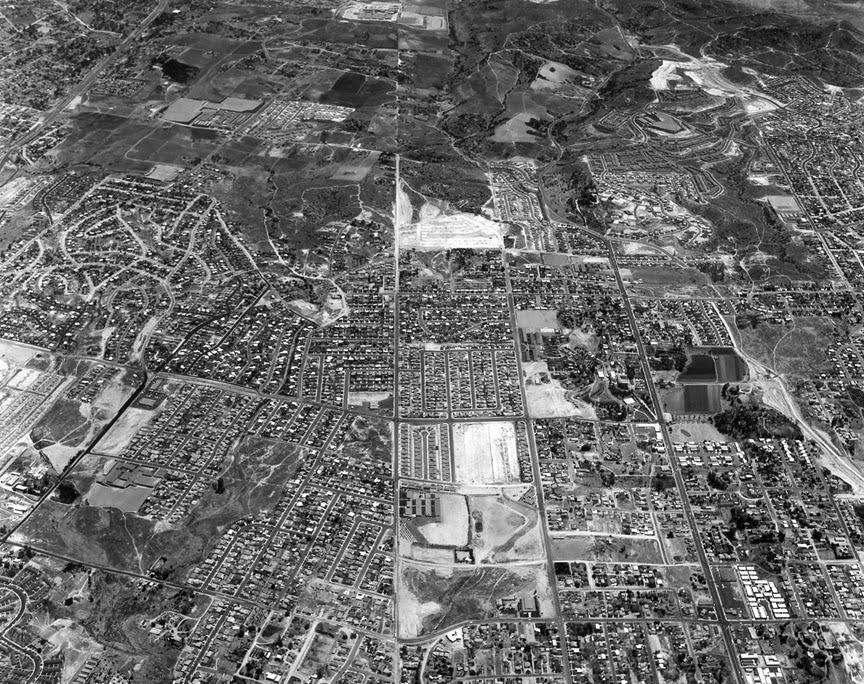
However, Southern California, especially the greater San Diego region, didn’t have divisive highways when those communities were initially developed. For San Diego and the greater Southern California region, one only has to look to the Robert Moses of the West, Mr. Caltrans, Jacob Dekema. Dekema came to the San Diego region in 1955 as its first Caltrans district director. At the time, the region was home to only 25 miles of highways. When Dekema retired in 1980, he had overseen that network growing into 485 miles of highways and entrenched a culture dependent on the car.

A black and white aerial photo shows the relatively dense community of National City before the highway boom.
National City, CA before the I-805 Expressway. (Source: John Fry)
Google Earth screenshot shows a more recent picture of National City, with large roadways highlighted in yellow lacing through the city's core
National City, CA with the I-805 Expressway and defunct SR-252 spur (future park site). (Google Earth)

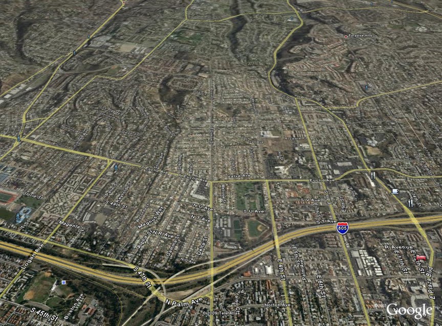
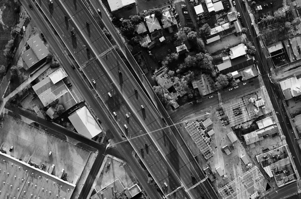
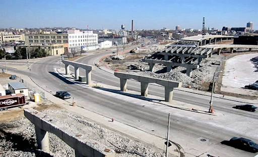
One of those communities in the shadows of, and sliced by the intrusive, life-sized sculpture dedicated to the car, is National City, CA. This diverse community of 56,000 as of the 2020 census, had its community sliced and diced by the sprawling highway creation. I-5 divides the city from it’s waterfront to the west, and I-805 runs through the heart of the city’s east side.

The 805, like many highways across the country, came into consciousness around 1956, with its construction in the late 1960s that wrapped up by 1975. Parallel to the highway’s construction, efforts in National City in 1969 revisited zoning to facilitate auto-oriented strip mall development, further setting up a concrete jungle for residents.

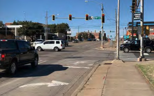
The most disruptive and obsolete highway construction for I-805 is Exit 11A. This exit was built to facilitate a highway to future highway transfer (what was to be known as the El Toyon Freeway or SR-252). Through intense community advocacy and opposition, the Toyon Freeway project was canceled in 1980 and removed from consciousness in 1994. However, Exit 11A remained, today serving as the 43rd Street exit, which drops a driver off at the auto-oriented Southcrest Park Plaza.

Seeds of a movement

Two women crouch in front of a child playing in the grass, with a raised highway looming in the background
Since the construction of the Interstate 805 Corridor in 1967, SESD and National City have grappled with the legacy of redlining and infrastructure divisions. (Mundo Gardens)

The multicultural tapestry that connects National City and Southeast San Diego (SESD) today has been left with a disproportionate share of challenges. The community lacks green space, has high levels of diesel particulate matter exposure, faces transportation barriers (due to the intricate web of highways around it), plus more and bigger cars zooming by community streets. These challenges have eroded the community’s quality of life, health outcomes, and well-being, particularly for those living in low-income households.

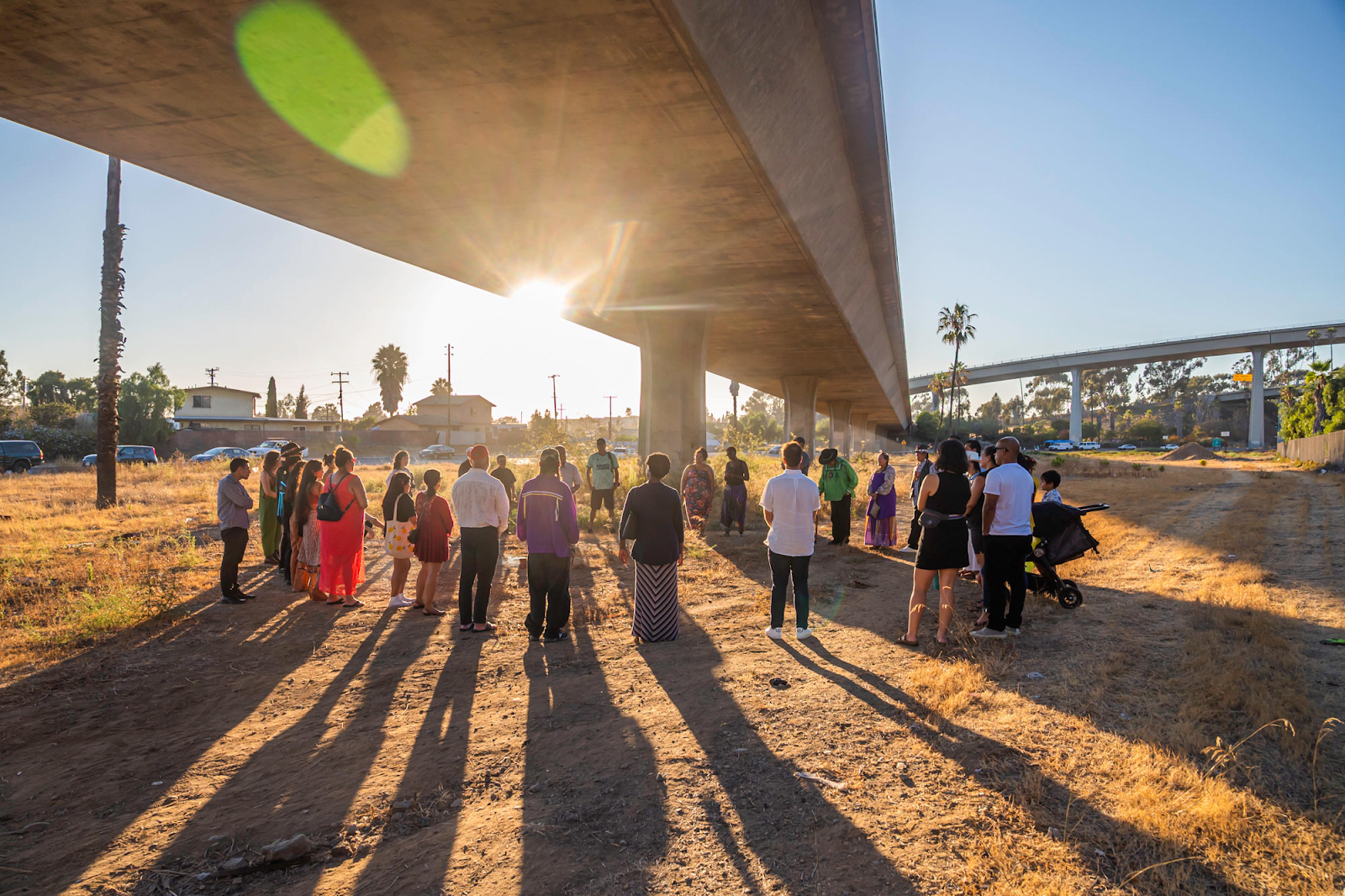
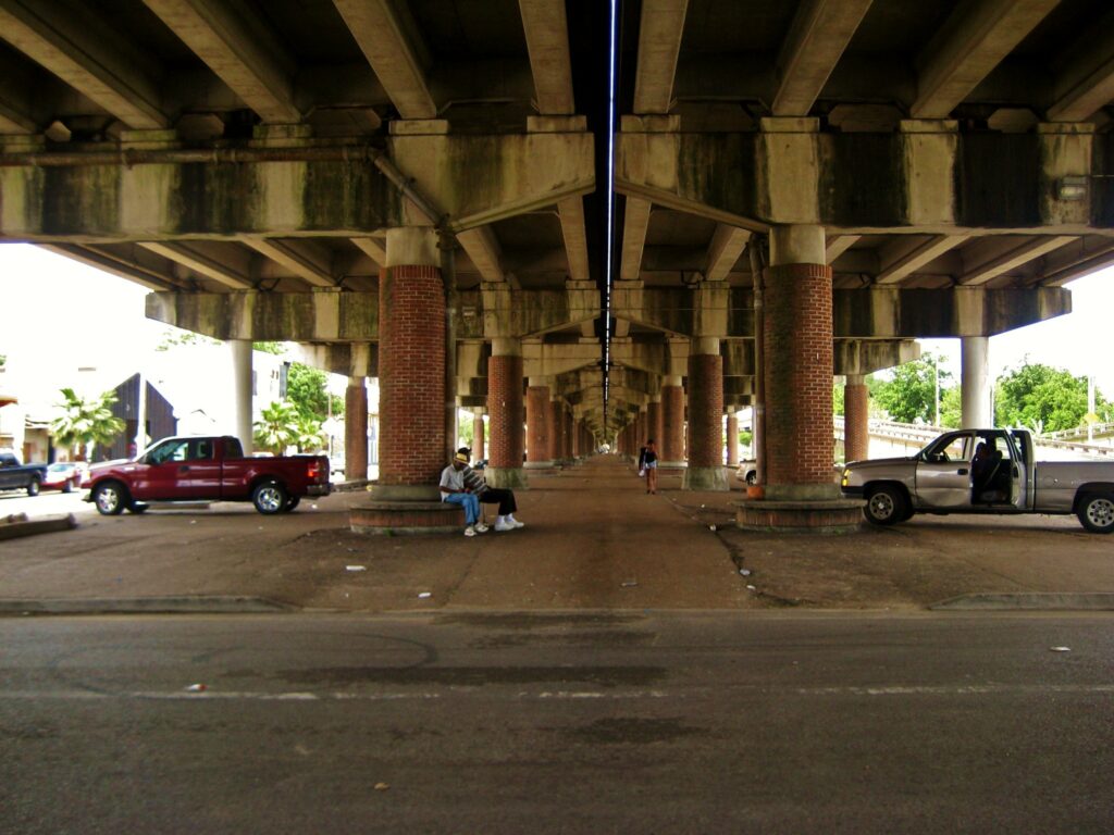
There is considerable acreage lying fallow under the shadow of the 43rd Street ramp. The land under the freeway occasionally is used by Caltrans as a highway maintenance and operations storage space, but otherwise remains a living scar for the community, overlapping National City and Southeast San Diego and preventing them from being fully connected to their fellow neighbors. With the economic decisions made in the 1960s, economic development opportunities remain poor in the area, with value generated in the area not fully captured and invested back into the community.

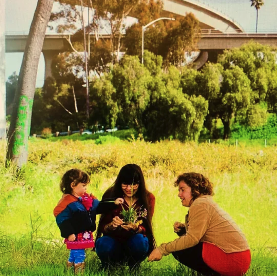
Even in the midst of an overbearing highway structure dividing various neighborhoods in northeast National City and Southeast San Diego, members of the community have worked to bridge infrastructure divides through cultural activities and streetscape beautification. One of those efforts, Joe’s Pocket Farm, has served as a catalyst for area advocates to push for a holistic community vision to reconnect the community.

Starting as a vacant land plot by I-805 and Division Street, Mr. Jose Nuñez cultivated a pocket garden near his home for many years before moving away from the area in 2008. This pocket garden fell into disrepair and turned into a dumping ground until community members organized to save the garden and turn it into a community asset. In late 2009, community members engaged the National City City Council to reclaim the vacant and dilapidated garden into what is today the Joe’s Pocket Farm. This advocacy and organizing ultimately led to the creation of a local-area nonprofit, community garden, and social justice organization, what is Mundo Gardens today, which is aimed at empowering youth and community members on cultivating solutions to address social determinants of health.

Not long after Mundo Gardens’ founding, the Urban Collaborative Project (UCP) was formed. Created in 2013 as a nonprofit organization serving redlined communities in National City and Southeast San Diego, UCP leverages a data-driven, community self-healing approach to tackle key issues, including building social infrastructure and capital, transportation and infrastructure equity, health disparity and environmental justice, cultural beautification, and housing and community development.

Developing and executing a community vision

A group of people gathers around a circular table covered in posters and sticky notes, hard at work
National City / Southeast San Diego community coalition at the RWJF Community Connectors Convening in Atlanta. (Smart Growth America)

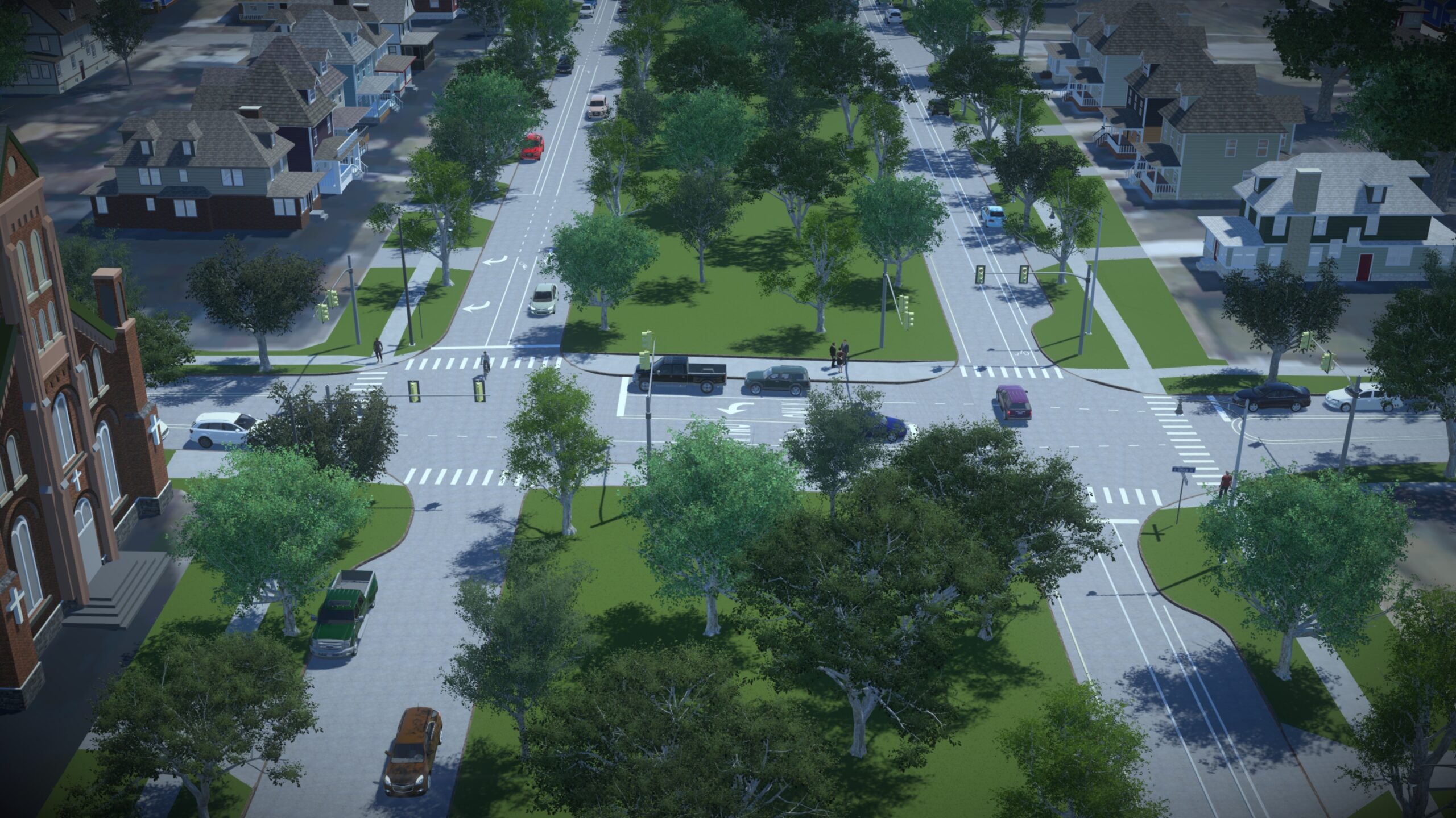
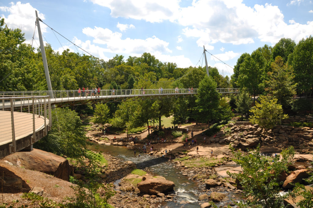
Mundo Gardens and UCP are pieces of a larger community-driven movement that has been in the making over the past two decades on reconnecting their community and mitigating social determinants of health. Community conversations have scoped out the Greenspace Corridor Project, which would unify National City and Southeast San Diego through reforestation, cultural art, and community. This project aims to accomplish various tasks, including but not limited to, 1) dismantling the 43rd Street exit ramp from I-805 and the defunct SR-252 built segment, 2) creating a community park on the reclaimed highway land centered on community culture, community health, and the natural environment, 3) stimulate social equity investment in the community, and 4) reconnecting the greater community to its culture and heritage.

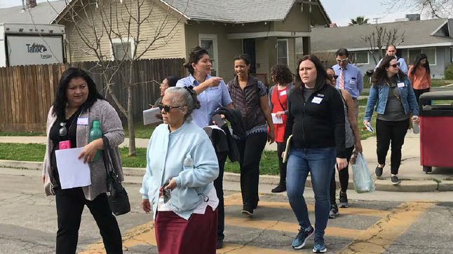
The National City / Southeast San Diego community coalition, which is advancing the Greenspace Corridor Project, has made great strides in building its community network, which now includes city staff from National City, Council of Equity Advocacy San Diego, Kumeyaay Community College, Tocayo Engagement, SANDAG staff, Caltrans District 11 staff, among others.

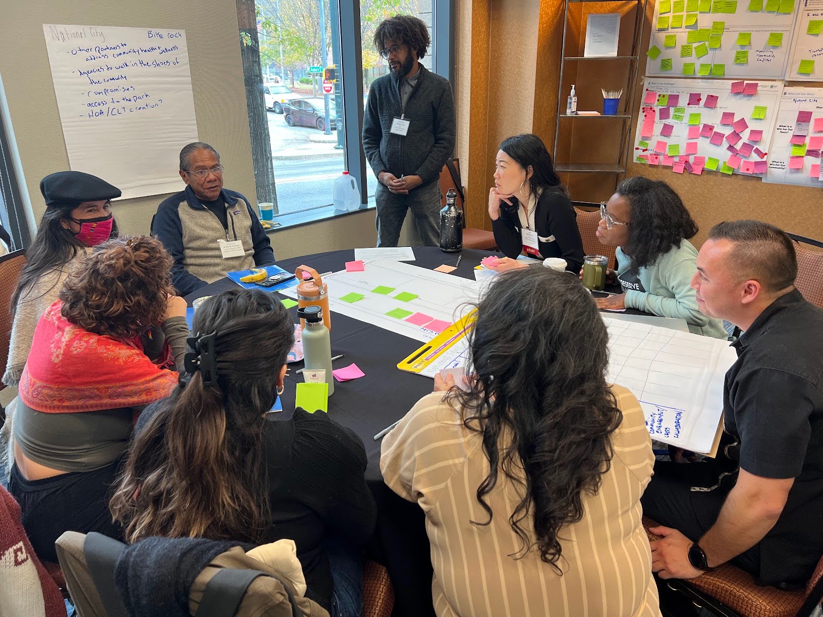
This coalition joins other community coalitions around the country selected in July 2023 to be part of the Community Connectors program. This program has allowed the National City / Southeast San Diego community coalition, alongside their peers, to access technical assistance and capacity building support to advance their community project. In November 2023, the coalition met alongside their peers in Atlanta for a Community Connectors convening. At that convening, the National City / Southeast San Diego community coalition was able to map out project challenges and possible wins, plus flesh out a preliminary implementation plan.

In March 2024, the community coalition received double good news: two major wins in their collective advocacy and outreach efforts to support and fund the Greenspace Corridor Project. On March 12, 2024, Caltrans announced the coalition as one of three grant winners of the state’s Reconnecting Communities: Highways to Boulevards pilot program, totaling around $50 million for planning and implementation efforts that advance the project. The very next day, USDOT announced the coalition also won a $2 million Reconnecting Communities & Neighborhoods Program planning grant.

Looking to the future

Community members gather beneath the 43rd Street exit, a large check in hand, ready to tackle their project
National City / Southeast San Diego community coalition at the Caltrans Reconnecting Communities: Highways to Boulevards press conference. (City of San Diego)

The Greenspace Corridor Project holds much promise with a strong and emboldened coalition that now has seed funding to actualize their project. However, the work is only beginning, as the coalition will now begin the figurative and literal cultivation of their community garden. Later in 2024, the National City / Southeast San Diego community coalition will organize and deliver a community convening aimed to advance the conversation held in Atlanta and more fully flesh out a project implementation plan. The coalition also aims to enhance community engagement, storytelling, and outreach to raise awareness on the project and broaden stakeholder support. Lastly, the coalition aims to continue to pursue additional local, state, and federal resources to realize the community park that is centered on community health, culture, and economic opportunity, expanding what started as a small pocket farm from the hands of Mr. Nuñez.

Two years in, progress still needed for reconnecting communities

Black and white aerial image of a highway separating a neighborhood from a row of businesses

In March 2024, the Office of the Secretary at USDOT announced awards for the Reconnecting Communities Program. This program is intended to improve access to daily needs and repair past harms by removing or mitigating divisive infrastructure, particularly in disadvantaged communities. This year, funding was expanded from last year’s awards, but will these funds meet the program’s goals?

Black and white aerial image of a highway separating a neighborhood from a row of businesses
The Reconnecting Communities Program presents an opportunity to address past harms. (Unsplash, Judah Estrada)

As we explained in our report Divided by Design, low-income communities and communities of color have been and continue to be disproportionately harmed by our approach to transportation in the United States. Past decisions, including routing the Interstate Highway System through communities of color, dividing and often demolishing them in the process, still shape our built environment. Without change, people living in communities divided by harmful infrastructure are more likely to be exposed to air pollution, face an increased risk of being hit and killed while walking, and experience reduced access to jobs and opportunity.

A small program to knit communities back together

Last year, we reviewed the first round of awards from the Reconnecting Communities Pilot Program, a discretionary grant program aimed at mitigating the damage caused by divisive infrastructure. The second round of awards, announced this year, was combined with the Neighborhood Access and Equity (NAE) program, forming the Reconnecting Communities and Neighborhoods Program (which we’ll call the Reconnecting Communities Program). It’s important to note that because NAE funds were allocated all at once, these past two rounds of investment represent the majority of federal funds dedicated to reconnecting communities projects. So how is this investment going?

Many federal infrastructure grants and formula funds go toward highways in some capacity—our recent analysis of state spending found that about 25 percent of federal formula funds are being used for highway expansions. By comparison, safety projects and reconnection projects do not receive the same amount of investment or attention. The Reconnecting Communities Program, though relatively small (roughly $3.3 billion this year) compared to federal formula programs, presents an important opportunity to finance projects that prioritize reconnecting communities.

A lot of the communities that were awarded funding utilized their awards for the Reconnecting Communities Program’s exact intent—they’ve begun work on constructing pedestrian bridges or bike infrastructure, or they’re using the funds to study the feasibility of new routes to bike, walk, and use public transit in their cities. For example, the City of Milwaukee received a $36 million construction grant to build bike and pedestrian infrastructure, as well as transit, along its 6th Street corridor, widened in the 1960s to accommodate vehicle flow from I-94 and I-43, two divisive highways that demolished Black and Brown homes in the mid-1900s. The new project will allow the surrounding neighborhoods to access jobs and services downtown. The Port of Los Angeles received a $5 million grant for a waterfront pedestrian bridge. This project aims to construct a pedestrian bridge over two main freight line tracks, connecting the community to greenspace along the water.

Perpetuating divides

Despite many of these projects using their grant money towards needed improvement and connections, some of the grant funding will not be fully utilized to connect communities. For example, projects that add safety features for people walking and biking around large, dangerous roadways are improvements overall, but they won’t go far enough to truly address divisive infrastructure. These projects would likely be a better fit for larger, more flexible funding sources than a small, specific program like the Reconnecting Communities Program. By using reconnecting communities funds to skirt around divisive infrastructure rather than address it head-on, we risk missing out on more ambitious initiatives to reduce and repair harm.

Aerial photograph of I-5 in Rose Quarter, showing several wide lanes that divide the community
I-5 Rose Quarter area as of 2022. (Flickr, Oregon Department of Transportation)

One of the more egregious examples of an awarded project would be the I-5 Rose Quarter Improvement Project in Oregon. The planned expansion of I-5 in Rose Quarter has faced resistance for years, including from young climate activists at the nearby middle school already exposed to harmful air pollution from the existing highway. ODOT’s plans to cap the highway (while still expanding it) received $450 million in funding from the Reconnecting Communities Program. In this case, the program will mitigate a new harm, not repair a mistake from the past.

The I-5 project is not alone—America Walks identified four projects that received funding from the Reconnecting Communities Program that will ultimately lead to more displacement and approach reconnecting communities as an afterthought. The program is intended to address past divides, but as current decision-making continues to perpetuate harm, this small federal program must bridge an ever-widening gap.

Looking ahead

The Reconnecting Communities Program represents a start to bringing communities together and supporting safe, low-cost, and low-emission travel. The program is still new, and the next reauthorization will present an opportunity to strengthen and expand it. In the meantime, USDOT has an opportunity right now to improve on the substance of the projects that are awarded. USDOT should place a larger emphasis on purposefully moving away from highway systems and provide examples of projects that improve safety and connectivity, such as bike infrastructure and bus rapid transit. In addition, advocacy at the local and federal levels can continue to raise awareness of the importance of connecting communities and building safe streets.

Our current transportation system prioritizes the movement of vehicles over all else, and communities of color and low-income communities have often paid the price. To make a substantial impact in addressing community divides, local and federal agencies will need to take a closer look at how their existing models and practices enable further harm, and work to reshape the system for the better. Learn more here.

Restoring Buffalo’s “Emerald Necklace”

A park extends down the center of two narrow streets

Humboldt Parkway, once home to vibrant public space, was destroyed by the Kensington Highway, displacing over 600 families and leaving a concrete gash through Buffalo’s network of city parks. With federal support, the Kensington Expressway project aims to reconnect the community.

The rendering below is not an accurate depiction of the Kensington Expressway project. After hearing from local advocates, we’re working to uplift the on-the-ground experience that paints a different picture than the one we initially shared.

In the meantime, take a look at this article that sheds more light on the situation in Buffalo and check the rest of our case studies that demonstrate the right way to heal the divides caused by divisive infrastructure…and the stories where those efforts have gone wrong.

A park extends down the center of two narrow streets
NYSDOT rendering of the Kensington Expressway Project

Mind the gap: USDOT’s first take on reconnecting communities

A group of people representing a range of ages, genders, and ethnicities walk across a cracked road within a marked crosswalk.
Residents of Fowler, CA assess current conditions along State Highway 99 and Golden Street Corridor, which did not receive a Reconnecting Communities grant in the first round of funding. Photo credit: CalWalks and safeTREC

In March 2023, USDOT announced the initial 45 awardees for the opening round of the Reconnecting Communities Pilot Program. This first-of-its-kind program represents the start of a new series of initiatives that confronts the legacy of inequitable infrastructure projects in the US and will (un)pave the way for the Neighborhood Access and Equity Grant program created in the Inflation Reduction Act. But to meet the needs of communities, the USDOT needs to expand its vision and scope of funds available.

An excavator digs a massive hole titled "Dangerous Roads $$$". On the other side of the hole, a man tries to fill the hole with a small pile of dirt (labeled "Safety Improvements $." The comic is labeled "U.S. Approach to Road Safety."
This illustration was produced for T4America by visual artist Jean Wei. IG/@weisanboo

435 communities applied for the first round of the Reconnecting Communities Pilot Program (RCP), despite the fact that only $195 million in funding was available. To put this in perspective, the  Multimodal Project Discretionary Grants (MPDG) program received about the same number of applications for nearly 15 times the funding ($2.85 billion). If those numbers are anything to go by, we can see that the demand from communities to fix divisive transportation infrastructure far outstrips what even the largest discretionary grant programs could garner. This is especially true when formula funding, which dwarves discretionary funding, continues to perpetuate the very issues the Reconnecting Communities Pilot seeks to resolve. 

That demand comes from a diverse array of applicants. The Reconnecting Communities Pilot program received applications from 51 states and territories, from smaller communities like Phenix City, Alabama, home to less than 40,000 people, to large cities with millions of residents like Philadelphia and Los Angeles. 

With that variation in size came variations in resources. We know some of these project applicants, like the grant-winning recipient Reconnect Rondo, hosted accompanying websites and social media pages managed by activist community partners, boosting the strength of application narratives. On the other end of the spectrum, two individuals applying to the program accidentally gave their own names instead of the name of the city that the grant would apply for, a sign of the difference in preparedness for the competitiveness of this grant program.

Who were these applicants? USDOT has done great work releasing outcome information in this first year of the program, and we acknowledge their efforts to release the name and state of aspiring applicants. However, we are still missing crucial information to assess how funding has been distributed and lack information on 21 applicants. T4A has requested more data from USDOT, including the individual census tracts used to assess each community as disadvantaged according to the Justice40 initiative.

In the meantime, we conducted an analysis of every applicant at the county level using data from EJScreen, the EPA’s Environmental Justice Screening tool. Though this method has limitations, it allowed us to learn more about the applicants, even those who did not receive awards and a profile from USDOT, across a variety of environmental and social measures. See the below map of applicants, with successful applicants marked in green and unsuccessful ones marked in red:

While it may be difficult to quantify the social costs of divisive infrastructure, the costs to physical health remain apparent. Including those who did not receive an award, RCP applicants had on average lower air quality, higher risk for cancer, lower income, and higher rates of unemployment than the typical American community according to EJScreen data. Many of these communities are severely marginalized, and may only be able to heal if we increase RCP funding to meet demand.

Among these many applicants was Stillwater. Stillwater is a smaller city in Oklahoma, and like many communities in the United States, highway infrastructure has left its mark on the community. Two state highways cut through the city’s downtown, creating dangerous barriers to people walking or biking in the city. In an attempt to undo the damage and support its status as a growing active transportation hub, Stillwater applied for an RCP grant to plan for a new pedestrian bridge over State Highway 51 and create a new active transportation map to connect the city and increase protections for vulnerable road users.

Photo of highway facing Main Street, with right turn lane directly next to sidewalk
Current conditions along State Highway 51 place pedestrians dangerously close to fast car travel. Source: Stillwater, OK Corridor Plan

Further west, Fowler is a small agricultural city in California. CA State Highway 99 and Golden State Boulevard cuts diagonally across Fowler, preventing access to almost half of the city. The community applied for an RCP grant to better connect the community across the highway. Fowler is located in Fresno county, which has some of the worst air quality and pollution in the nation.

Edinburg, Texas applied for a planning grant to convert a high-speed, arterial-style road into a Complete Street. The road, which requires children to walk across a nearly 80-foot-wide unsignalized crossing, runs adjacent to neighborhoods, a playground, and an elementary school. According to EJscreen data, Edinburg’s county has some of the country’s worst cancer-causing air pollution and has a higher proportion of people earning under the federal poverty line than 84 percent of the country. 101 of 113 census tracts in the county were identified as disadvantaged according to Justice40 metrics.

The outsized demand for the Reconnecting Communities Pilot and widespread community interest in the program’s unique mission is a sign that the pilot has been a resounding success. But with current levels of funding, the RCP will not be able to meet the massive scale of community need. Instead, USDOT should increase funding for the Reconnecting Communities Pilot and the Neighborhood Access and Equity Program to meet this historic demand. 

But competitive grant programs cannot be communities’ only recourse to restore community links. Funding for the Reconnecting Communities program would have to expand by an order of magnitude to meet the demand from hundreds of qualified communities. The approach to funding these types of projects needs to change on a system-wide level, and there’s no better way to fund these projects than through formula dollars. Almost 90 percent of Highway Trust Fund funding goes to formula programs, and states have vast flexibility in how formula dollars could be used. Most, if not all, reconnecting communities projects would already be eligible under existing formula programs. States should take the opportunity to use formula dollars to reconcile the legacy of damaging transportation infrastructure, rather than repeat past mistakes.

Eligible communities have an opportunity to apply to Smart Growth America’s Community Connectors program to help prepare for the next round of competitive Reconnecting Communities grants and other funding opportunities.

New Community Connectors grant program and resources for advocates

A new grant program from Smart Growth America will help advance locally driven projects that will reconnect communities separated or harmed by transportation infrastructure and tap available federal and state funds to support them.

Removing divisive infrastructure is largely uncharted territory in the United States, but the need to fix the damage it has caused is imperative. Transportation infrastructure like divisive highways and dangerous arterial roads often separates and harms the communities living around them. This is particularly true for Black and Brown communities, who are more likely to live near large roads and have to live with the environmental, economic, and social harms they cause.

The movement to remove divisive infrastructure has often required communities to be pioneers and the lack of a roadmap and the nature of the work often meant that there were few others to easily learn from. The Community Connectors grant program aims to change that by providing financial resources to help build local capacity and advance these projects, but also by connecting local leaders to experts and other cities attempting to accomplish similar things.

Applications are due before July 15, 2023 at 11:59 p.m.

Who is eligible to apply for the program?

Community Connectors welcomes diverse, multi-entity project teams from small to mid-sized U.S. cities (between 50,000–500,000 in population) to apply for the program. Teams may consist of non-profit community-based organizations and advocates, government agencies (including U.S. territories), and tribes. For-profit entities may be part of the wider project team but are not eligible to receive any of the funds directly or indirectly disbursed through the grant or technical assistance.

What support will selected teams receive?

Selected teams will receive grants of up to $130,000 for capacity building and to advance their projects. In addition, the selected teams will also receive customized technical assistance and participate in a learning exchange program over the next 18-24 months, which includes an in-person convening in Atlanta, Georgia, in November 2023.

What kinds of projects are eligible?

We encourage teams to submit proposals for projects or concepts to reconnect communities separated or harmed by transportation infrastructure through an integrated transportation, land-use, housing and economic development approach. Applications for proposals at all stages are welcome. Teams are not required to have applied for or formalized an application for U.S. Department of Transportation programs.


The Community Connectors program is led by Smart Growth America in partnership with Equitable Cities, the New Urban Mobility Alliance, and America Walks and is supported by the Robert Wood Johnson Foundation.

Bonus: New tools for all “Community Connector” advocates

In coordination with this new grant opportunity, we have launched a brand new suite of resources to support all Community Connectors in communities of any size. These are the advocates all across the country who are working to reconnect their communities: fighting freeway expansions, advancing projects to remove old highways, making wide, dangerous arterial roads a little safer for people to cross, or just improving basic infrastructure people depend on each day.

While the new grant opportunity is limited, Transportation for America’s Community Connectors portal is for anyone, providing tools and information for advocates to decode the complex and confusing maze of programs, acronyms, and decision points that determine what gets built with federal and state transportation dollars.

Expect to hear much more about this new portal of resources. Our team will be regularly updating it with new explainers and stories over the coming months.

Want to get updates on new content? Be sure to sign up for our email list here.

House threatens funds for reconnecting communities

press release

The House’s debt ceiling package, H.R. 2811, proposes cuts to several programs, including the Neighborhood Access and Equity Program established under the Inflation Reduction Act. In response, T4A Director Beth Osborne issued the following statement:

“The Neighborhood Access and Equity Program is a valuable, needed investment that will support local economic development and knit communities back together across overbuilt and obsolete roadways. Governments across the country are looking for federal partners to build safer, better connected, and more prosperous communities. The program has not even begun, so now is not the time to strip the program’s funding. But that’s exactly what the House’s debt ceiling package H.R. 2811, also known as the ‘Limit, Save, Grow Act,’ would do.

“That’s why we’re leading a sign-on letter with organizations nationwide calling on Congress to keep the Neighborhood Access and Equity Program fully funded so we can realize the benefits of these critical investments.”

This letter can only be signed by elected officials and those authorized to represent their organization.

Sign the letter.

San Juan, PR: Trampling communities and a national rainforest in the name of “economic progress”

Aerial view of Puerto Rico prior to PR 66 construction with forest and aerial view of PR 66 after construction with forest construction and sprawl

Deemed a project of major economic significance for several decades by the Puerto Rico’s Department of Transportation (DTOP), the agency rammed through community opposition, environmental review processes, and legal battles to construct PR-66, a limited access tollway that is benefitting few and scarring communities and their environs.

Aerial view of Puerto Rico prior to PR 66 construction with forest and aerial view of PR 66 after construction with forest construction and sprawl
Images of PR-66’s Construction in February 1999 (Source: A. Casas-Macias, UAGM) vs Present Day (Google Earth)

History and context

As its historically rural population rapidly urbanizes, Puerto Rico has been iterating ways to stimulate and diversify its economy and facilitate speedy travel. Because of its status as a US territory, Puerto Rico’s transportation policy and investment strategy has been molded by an auto-centric lens pushed by both Washington and private sector investors filling transportation funding gaps for decades. However, federal transportation investment in Puerto Rico has been scant. (For example, in fiscal year 2022, Puerto Rico received $173 million in federal funding from the 2021 infrastructure law. Compare that to Utah, with the same population receiving $460 million or Connecticut, with slightly larger land area receiving $665 million.) Because of limited transportation funding, Puerto Rico has had to rely on private sector investment, which prioritizes roads with tolls over transit.

In the 1960s, inspired by the Eisenhower Interstate Plan, Puerto Rico created its Highway Development Plan with the goal of creating high speed roadway connectivity of the various island communities to San Juan. From this plan, all but one of those highways were built by the 1990s. The highway yet to be built would prove to be the most hotly contested. 

PR-66, as envisioned by the Puerto Rico Department of Transportation and Public Works (DTOP by its Spanish acronym), connects PR-1 (the historic route between San Juan and Ponce) and PR-52 (an expressway parallel to PR-1) to PR-3 (the historic route that connects the eastern island communities to San Juan) and the PR-53 northeastern terminus.

Aerial view of PR 66 proposed route. More information available in the paragraph above.
Approximation of the originally proposed PR-66 Corridor route

A hard-won battle over federal regulations

Development of this 31-mile 4-lane tollway corridor started in 1992, when the National Environmental Policy Act (NEPA) process began. This process required the DTOP to assess environmental considerations, such as noise, water, air pollution, stormwater runoff and erosion, impact to historical resources as well as community displacement.

DTOP justified the route by arguing it would reduce congestion (reducing travel time from Fajardo to San Juan by 30-40 minutes each way), increase travel time reliability for vehicles, and stimulate economic growth and job creation in the corridor.

Communities along the proposed corridor were caught off guard as the NEPA process got underway. A sole public meeting on project impacts was held two days before New Years Eve 1992, providing little to no information to the community, soliciting minimal feedback, and yielding a questionable Environmental Impact Statement (EIS). In May 1993, the Environmental Quality Board (JCA in its Spanish acronym) provided preliminary feedback on the EIS, stating that the EIS was only analyzing economic impacts and failing to assess other critical aspects of the NEPA process which include displacement, environmental degradation (like runoff, erosion, and noise), and never exploring alternative solutions to achieve the project’s purpose and need. Additionally, the JCA questioned DTOP’s vague analysis, as well as its statements on where and what it intended to build in the corridor. Despite some procedural setbacks, DTOP proceeded to develop the project and move to finalize the EIS. By the mid 1990s, DTOP began to seize homes and businesses via eminent domain to clear the way for road’s construction. 

A local resident, Wanda Colón Cortés, was outraged with how DTOP was skirting the NEPA process, and she created a group of community members called the Communities Opposed to Route 66 to oppose the project. The demands from Communities Opposed to Route 66 were crystal clear: stop any construction and thoroughly evaluate the corridor for a broad array of alternatives and their impacts as required by NEPA. They reasoned with DTOP and JCA that they agree with the purpose and need of the project, but want to ensure a fair, thorough, transparent process. 

Rather than address the community’s comments, DTOP amended the EIS in February 1996 to shorten the corridor, and JCA declared this EIS adequate in May 1997. In 1997, arguing that the EIS determination was premature, Communities Opposed to Route 66 took both DTOP and JCA to court. The case would be interfered with by the Puerto Rico legislature, and go all the way to the Puerto Rico Supreme Court by 1999. The community group declared victory in April 2000, when the Puerto Rico Supreme Court issued its ruling, determining that:

  1. The legislature’s involvement violated separations of powers and deemed their actions unconstitutional,
  2. JCA could not be edited out of the environmental review process as DTOP and the legislature attempted, and 
  3. The NEPA process needs to be thoroughly followed for the full proposed corridor, not just its segments.

A highway slowed but never stopped

After DTOP was defeated in court, it went back to the drawing board and prepared a new EIS draft in late 2001, focused exclusively on a 13-mile segment of the original corridor (now Canovanas to Carolina). When presented with this proposal, the community again expressed discomfort over environmental impact and community displacement. So DTOP tried again, and in 2002, they prepared an EIS that placed the corridor further away from the existing community—encroaching into the El Yunque National Rainforest instead. Because this proposal impacted fewer community members, community opposition dwindled. DTOP was then able to finalize the EIS in late 2002, with construction of the corridor starting by summer 2003.

The PR-66 toll corridor would fully open in October 2012 under a 50-year public-private partnership agreement, but it was not without other issues along the way. On multiple occasions, the project required additional funding to continue and complete construction, with $160 million for seizing other properties along the corridor. In late 2006, the Northeast Ecological Corridor Coalition blasted DTOP in an op-ed for El Nuevo Dia (the island’s main newspaper) for not doing enough to mitigate environmental harm and failing to follow through on its promises in the EIS. 

That coalition also emphasized that the JCA needs to fulfill its role in reviewing and providing oversight on DTOP’s environmental mitigation, especially on stormwater runoff, erosion, noise and air pollution, water quality, and deforestation. This sentiment was shared by Fanny Peña Roque, a community advocate, who called out DTOP for not mitigating community access to jobs and services for their cut off mountainside community to facilitate speeding up construction. Her community remained cut off for months, even after the highway project was completed. 

The coalition also tried to raise the alarm on the impact PR-66 has and will continue to have on incentivizing new suburban sprawl and the incongruent development across communities within the corridor (with even some new developments caught in the crosshairs of the corridor for seizure after recently being approved and/or built). But these calls never gained momentum. 

Ten years have passed since the full opening of the PR-66 corridor. Traversing it today traffic volumes are very low (no more than 30k average annual daily traffic volume), roadway fatalities high, erosion and flooding impacts a regular occurrence, and toll rates are very high (at 30 cents per mile, it is the second most expensive roadway in the United States) with deliberations in the past year to increase toll rates to help with the project’s debt service.

Lessons for budding Community Connectors

Photo of the PR 66
PR 66 eastern termini at Rio Grande, looking westbound (Image from Wikimedia Commons)

Understand the regulatory tools at your disposal—and don’t be afraid to use them. As other communities look to challenge divisive transportation infrastructure, it will be important for advocates to be informed about the NEPA process and related regulatory requirements, and hold firm on accountability of those requirements. However, NEPA alone won’t be enough. 

Find your message and hold your vision, even as circumstances change. Community advocates fighting the PR-66 project needed to have a vision beyond protecting homes and buildings. Yes the project impacted homes and businesses, but advocates were unable to translate the messaging and sustained attention more broadly when DTOP revised the corridor footprint and continued developing and building the project. 

Recognize project alternatives. Advocates should also try to articulate a clear alternative approach to address the project’s purpose. Then Governor Luis Fortuño in a 2011 conference keynote (and under the backdrop of community protests) blasted opponents of the project, stating “Puerto Rico can’t permit the well being and progress of our community to be held hostage by people who think all progress is bad.” To address this issue, community connectors should work with other stakeholders to inclusively formulate an alternative vision/strategy to tackle the aspirations of present and/or proposed divisive transportation infrastructure.

Community Connectors: tools for advocates

You may be fighting against a freeway expansion. You may be trying to advance a Reconnecting Communities project to remove an old highway. You might be just trying to make wide, dangerous arterial roads a little safer for people to cross. This Community Connectors portal explains common terms, decodes the processes, clarifies the important actors, and inspires with helpful real-world stories.

Reconnecting the Hill District to downtown Pittsburgh

A brightly colored mural decorates the side of a building in the Hill District

In its heyday, the historic Hill District neighborhood was bursting with life. It was full of opportunities and culture; residents treasured it. After slowly cultivating a unique identity through generations and incremental layers of growth, it was nearly destroyed in just a few short years through the building of I-579 and the Civic Arena. Now, 60 years later, some connections are being restored.

A brightly colored mural decorates the side of a building in the Hill District
Mural of playwright August Wilson, who once called the Hill home. Photo from the City of Pittsburgh.

A cultural district cut off from downtown

The Hill District of Pittsburgh, Pennsylvania, located just to the east of the core of downtown Pittsburgh began as a community of freed Black men and women early in the 20th century. As the city’s first Black district, it became a “cultural icon,” known for its jazz scene, radio station, and weekly newspaper, the Pittsburgh Courier. Following World War II, the Hill’s aging housing infrastructure, in conjunction with “crime and disease” (how the city defined it) became the basis to justify drastic urban renewal. Over 95 acres were condemned by the city. Developers came in and began taking houses by eminent domain to “revitalize” the neighborhood. This was the beginning of a swift downfall for the Hill District.

Black and white photographic of a highway cutting through Pittsburgh, with a small segment of the highway outlined in green
Aerial view of Hill District (right) separated from downtown (left) by I-579, with project site for the “cap” connector outlined in green. Historic photo from Pittsburgh-Exhibition Authority.

The plan for I-579, which today cuts directly across Pittsburgh and crosses the Allegheny River to connect with I-279, was conceived almost a decade before any work began. In 1949-1950, there were ongoing conversations about building a highway from Liberty Bridge to Grant Street, at the the end of Bigelow Boulevard. This would cut across the Golden Triangle, enabling a quicker, less congested commute across the city. After a few years of back-and-forth over route and cost, the city and county finally agreed to split the cost of an “82-foot-wide, six-lane expressway.” The City Council passed an ordinance establishing the right-of-way for the partially elevated, partially below grade project, cutting through the Hill District. The repercussions of the expressway on the Hill District were either never considered or blatantly ignored.

Pittsburgh Post Gazette black and white aerial photographs of the Hill District before demolition (rows of clustered buildings) and after (large, cleared area for the arena and highway)
A before and after of the changes made to the Hill.

In 1957, much to the City Planning Commission’s displeasure, the state announced that Crosstown Boulevard would be part of the newly created national Interstate System and moved forward with a larger, wider highway than they had originally approved, now backed by federal dollars.

The expressway, built in two sections, was completed by 1964. Simultaneously (1961) a new arena (home to the NHL’s Pittsburgh Penguins) and adjacent parking were constructed in the Hill District (South Side). All told, the destruction required to build I-579 and the greater urban renewal efforts resulted in the displacement of over 8,000 predominantly Black residents and 400 locally owned businesses. In addition, almost overnight, the Hill District was cut off from downtown right next door. 

“The massive highway constructed at the base of the arena severed the residents of the Middle and Upper Hill from downtown and any kind of continuity with civic life,” according to this piece in Belt Magazine. For residents of this low-income neighborhood, in a (previously) well-connected central location, walking to work, or walking to access essential needs and services, was no longer an option. By the mid-1980s, the Hill District had “deteriorated into a shell of its former self.”

A path forward: The “Cap” Connector

Streets form an open square over another segment of roads
The open square is filled in with green space and sidewalks, allowing pedestrians to walk over land that was once entirely highway

Before and after cap construction. Photos from HDR, Inc.

Today, there is a new cap over a portion of I-579, creating a limited new connection between the Hill and Downtown, restoring access to employment, education, and services—now known as Frankie Pace Park. The cap and park were built (2019-2021) in the open air space above a portion of the below grade I-579 just to the west of the old Civic Arena site The project was initiated by the Penguins’ move into a new arena a few blocks away in 2010, after which the owner of the Penguins demolished the arena and replaced it with 28 acres of parking. The Urban Redevelopment Authority threatened to take one-fifth of the parking revenue unless 6.45 acres were redeveloped by 2020. The Penguin’s owner acquiesced. Approximately half of this land would become Frankie Pace Park, the remainder would be used for mixed-use development.

The space includes bicycle, pedestrian, and ADA access through and around the three acres of land, as well as rain gardens, performance areas, recreation space, and other public amenities. Improved sidewalks, lighting, and signage were included in the project for improved safety and use at all times of the day, as well as curb-cut ramps and enhanced crosswalks at intersections leading into the space.

This project was funded by a combination of federal and state sources including: USDOT through a TIGER (round 8) grant, PA Redevelopment Assistance Capital Program, PA Department of Transportation (Multimodal PennDOT), PA Commonwealth Financing Authority (Multimodal DCED), and PA Department of Conservation & Natural Resources (DCNR Keystone Recreation, Park and Conservation Fund). Several local agencies and foundations also provided funding.1

An additional aspect of this project was its location near an existing subway station, a new bus stop, and a (then) proposed bus rapid transit system (BRT). In March 2023, the Pittsburgh Regional Transit announced approval for the first phase of this project, connecting Downtown, Uptown, and Oakland. Five new stations will be added downtown, including one at Steel Plaza station, made more accessible to Hill District residents by the new park. The electric buses will move along dedicated lanes to ease congestion and improve commuter efficiency.

Map of proposed rapid transit (description in caption and in text above)
Map of proposed BRT. The red route indicates bus-only lanes and shows the new proposed stops between downtown (far left) and Oakland (middle-left).

Still more work to do

In August of 2022, Pittsburgh received a federal RAISE grant to further address the harms caused by I-579. Projects funded by the RAISE grant, including curb extensions, new sidewalks, and intersection improvements, will help make the Hill District a safer place to walk for those who are still left in the Hill District.

From the looks of the new park, it can be deemed a success. However, this new park and new connections do not address the issues of past and current displacement and harm that was done to this community over decades, and which continues today.

Lessons for budding community connectors

Transportation and land use are inherently intertwined. As we advocate for development, and redevelopment, and fight to reconnect communities, we must always consider how one variable impacts the others—at the micro and macro levels. The building of I-579 had tremendous repercussions on housing and access (to employment, healthy food, community services, etc). That transportation decision to cut an entire neighborhood off from opportunity to serve thru-commuters had cascading effects on land use decisions across the region. And then 60 years later, the land use decision to create the cap created valuable new transportation connections between the Hill District and downtown. These decisions are inexorably connected.

Projects like these can require significant cooperation and a diverse range of funding sources. Building an interstate is relatively simple—the federal government provides 90 percent of the funding for the project. But Frankie Pace Park, which took nearly a decade to develop, required the cooperation of multiple local, regional, and state agencies, leverage placed on private landowners, and funding from a wide range of sources. Engaging a broad range of stakeholders is required for these complex projects, so get everyone to the table.

The cap is a band-aid on a historical wound. The cap and new park, although successfully built, doesn’t do enough to right historical wrongs and steer the benefits to come from the connection to those who were displaced. The best intentions are no replacement for listening to, including, and prioritizing the voices of those who lost their neighborhood in the first place. Successful reconnecting communities projects should reflect the needs and goals of the existing community, and that can only happen by engaging everyone in the process and empowering them to shape the final product.

Community Connectors: tools for advocates

You may be fighting against a freeway expansion. You may be trying to advance a Reconnecting Communities project to remove an old highway. You might be just trying to make wide, dangerous arterial roads a little safer for people to cross. This Community Connectors portal explains common terms, decodes the processes, clarifies the important actors, and inspires with helpful real-world stories.

Tracking damaging divides in Gretna, LA

Two sedans break as a train approaches, unable to cross

In an astonishing sight in this small southern city across the Mississippi River from New Orleans, daily freight trains run right down the center of their main street. Local elected leaders and the busy nearby port are hoping to relocate this incredibly disruptive freight rail line, but they’ll have to raise local and state money, negotiate with freight companies, and apply for federal support to make it happen.

Two sedans break as a train approaches, unable to cross
An incoming freight train blocks traffic on an busy road in Gretna, Louisiana. Photo courtesy of Jimbaux’s Journal.

For the people of Gretna, Louisiana, miles-long freight trains are a part of daily life. But in a far different way than other smaller cities with a few at-grade crossings. Multiple times a day, freight trains cruise down the middle of their main street at 15 miles per hour through 120 unprotected intersections, grinding the city to a halt. Vehicles stop, people can’t cross the street, and the noise swallows nearby conversations. If a parked car is in the way of the train, the train stops, blocking traffic, as the operator tracks down the owner to remove their vehicle. 

But the people of Gretna aren’t taking this lying down.

This project is one of 15 that we are supporting through our Community Connectors grant program to help small and mid-sized communities repair the damage of divisive infrastructure. Learn more about that program from our parent organization, Smart Growth America.

Impact on Gretna

Situated just across the Mississippi River from New Orleans, the small city of Gretna is a vibrant, historic, and diverse community that functions as a critical trade hub for the region due to its proximity to the Plaquemines Port Harbor & Terminal District. Gretna, like many communities on the lower Mississippi River, developed around the railroad to house the industrial workforce that the freight rail companies served. One side effect of this complementary growth, however, was that daily freight trains continued to run through Gretna. And we do mean through Gretna.

Today, in one of the most astonishing sights around, freight trains from Union Pacific (UP) and the New Orleans and Gulf Coast (NOGC) railroads run right down the middle of 4th Street and Madison Street in historic Gretna, dividing the city in half and stunting the city’s growth. To appreciate the full impact on the city and the people of Gretna, watch this video:

For 12 minutes, the train blocks all of Madison Street and passes through 120 intersections, blocking emergency vehicles, personal travel, and economic activity. In 2006, a resident’s home burned to the ground as an emergency vehicle was held up for 20 full minutes, separated from the house by a passing train. 

In addition to the dozens of crashes between vehicles and trains in Gretna over the years, trains have also derailed in the city several times. Luckily none of them were carrying hazardous materials, but consider the impact of  a massive toxic derailment—like the recent one in East Palestine—right in the middle of a city street surrounded by homes and businesses.The public health and environmental damages would be orders of magnitude worse.

Call to action

In 2014, NOGC announced that it would be increasing freight service through Gretna to serve a new coal export terminal in Plaquemines Parish. This announcement sparked outrage from community members and catalyzed the pursuit of an alternative route as residents and public officials realized they could no longer ignore the problem. They collectively decided: the tracks had to go.

The first step was getting everyone to the table. A coalition that included Gretna’s Mayor Belinda Constant and representatives from Jefferson Parish and the New Orleans Regional Planning Commission quickly hammered out a plan with NOGC and UP to move the tracks several miles to the west, cutting through an industrial zone and away from the residents of Gretna. While this deal was good news, the freight companies were unwilling to chip in a cent to turn the city’s plan into a reality, preferring the local governments pick up the tab (for what would also be a more convenient route for the railroads). 

But this agreement with NOGC and UP did allow the coalition to enlist the help of the Federal Railroad Administration (FRA) in conducting an Environmental Assessment of the plan, finding that the realignment would eliminate 97 at-grade railway-roadway crossings, relieve congestion downtown, improve emergency access and evacuation routes, and even improve NOGC and UP rail service in the process. And, well, remove giant trains from the middle of a city street. The project was a slam dunk.

The proposed new rail route would avoid areas of persistent poverty, giving those areas more room to flourish.
A map from CSRS shows the current freight rail path through the city in black, the proposed new path in red, and the area around the existing tracks that would benefit from removal. Areas of persistent poverty around the existing tracks are highlighted in blue, several of which would benefit from removal.

Though the coalition was able to quickly garner support for the project, they’ve struggled to overcome its large price tag, especially with the railroads unwilling to contribute. Jefferson Parish and Gretna are willing to foot part of the bill, but will need federal support to get it over the finish line. They unsuccessfully applied for a Mega Grant from the U.S. Department of Transportation in 2022, and have applied for another one this year, which is currently pending before the FRA. Until  they come up with the necessary funds, this badly needed project will not move forward.

In the meantime, Mayor Constant and Jefferson Parish President Cynthia Lee Sheng have focused on stopping the problem from getting worse. When NOGC and Union Pacific wanted to build even more tracks through Gretna, Mayor Constant bought up portions of the land and halted further plans by the railroads to take city lands because the city felt that it had a stronger public purpose. The city was able to establish in court that the people of Gretna had more of a right to use their community’s land than the freight companies did.

Lessons for budding Community Connectors

This is an incredibly complicated and ambitious project, possibly the most among the 15 projects T4America and Smart Growth America are supporting through the Community Connectors grant program.

Gretna and Jefferson Parish, along with new stakeholders like Plaquemines Parish and the Port of Plaquemine, continue to seek funding for the project, regularly engaging the Federal Railroad Administration and their congressional delegation on the matter. Additionally, they continue to work through the finer points of negotiations with the railroads to ensure that there is a win-win project. Of note, the United States Department of Transportation has recently asked them to include improvements to the existing alignment (greenways, transit connections or other interventions) as part of a larger request that would showcase a range of public safety, freight efficiency and community revitalization benefits.

There will surely be dozens of lessons to come in the future, but here are a few things learned so far during this project:

In some instances, there are ways to challenge railroad, state, and federal land rights. This will not be feasible everywhere, but the case in Gretna proves that some courts are sympathetic to the public purpose arguments presented by a city. If you’re an advocate looking to stop a disruptive rail construction project, see if you can engage your local government to strategically acquire land, granting you leverage in court and otherwise.

Build as big of a coalition as possible. The real win in Gretna came from the extensive collaboration between all levels of government, and with the railroads, to move the costly realignment project to the point where it could possibly happen. The combined authority of Mayor Constant, Jefferson Parish, the New Orleans Regional Planning Commission, and the Federal Railroad Administration made the partnership with NOGC and UP possible, especially with the significant price tag attached to the coalition’s proposed solution.

Your most powerful advocates may be your elected officials—get them on board to fight for you. Gretna’s fight has taken more than a decade of persistent effort, but having a unified set of elected leaders to take the message to the railroads and negotiate was key. Advocates fighting similar David and Goliath battles against freight railroads, highways, or any other divisive infrastructure should take inspiration from Gretna and remain persistent. Proactively engage stakeholders to find mutually beneficial solutions. Understand competing perspectives and be willing to work through them. Engage your federal, state, local—and when applicable—railroad partners early and often.

Community Connectors: tools for advocates

You may be fighting against a freeway expansion. You may be trying to advance a Reconnecting Communities project to remove an old highway. You might be just trying to make wide, dangerous arterial roads a little safer for people to cross. This Community Connectors portal explains common terms, decodes the processes, clarifies the important actors, and inspires with helpful real-world stories.

A proposed bridge is haunting the Bay Area

A sunny hill filled with cheerful homes framed by a palm tree and blue sky

The Southern Crossing over the San Francisco Bay, proposed repeatedly over the past 77 years, has been rejected over and over again. Even as Reconnecting Communities funds will help Oakland study repairing the damage resulting from the interstate spur rammed through the heart of Oakland to serve as the eastern approach for this never-built bridge, the Southern Crossing shows how past choices continue to haunt the present—and future.

A sunny hill filled with cheerful homes framed by a palm tree and blue sky
The beautiful hillsides of the Bayview residential neighborhood in San Francisco. Image Source: Bayview Hunters Point Community Advocates

History of the Southern Crossing

The Southern Crossing is an additional Bay bridge highway crossing that has been proposed over a dozen times since the plan was developed (in 1946) by various departments of California’s state government. The proposed bridge would be the fourth bridge to cross the San Francisco Bay, partner to the built “northern crossing” pictured above in yellow. As shown above, the “southern crossing” would originate from the east side near Bay Farm Island (fed by a new interstate, I-980), cross to the west side, and land on the San Francisco peninsula in the Bayview neighborhood, at Hunters Point. The vision was to provide East Bay motorists on I-580 and Highway 24 with a direct connection to I-280.

Historical map of proposed Bay bridges. Description in first paragraph under "History of the Southern Crossing"
Map of proposed Southern Crossing Highway Bridge: Source: Wikimedia Commons

In 1961, the Southern Crossing bridge came close to construction, but white environmental activists concerned about the environmental degradation of the Bay prevented the project from moving forward. Even though the bridge was dead (for now), construction of I-980 moved ahead in the heart of Oakland, starting over two decades of work that would ultimately divide Black residents in West Oakland from downtown and demolish over 500 homes and nearly two dozen businesses and churches

Simple map with I-980 in red slicing between West Oakland and downtown Oakland
I-980 separates West Oakland residents from downtown. Image by OpenStreetMap.

In 1971, a bill for the construction of the Southern Crossing was passed in the California State Assembly by both houses but vetoed by then-Governor Ronald Reagan, who believed that the citizens of the Bay Area should weigh in on the decision to construct such an expensive and controversial infrastructure project. Voters rejected a bond measure in 1972 that would have paid for the construction of the bridge via a toll increase on existing bridge infrastructure by a three-to-one margin. Without the bridge, the finally completed, roughly two-mile stretch of I-980 ended abruptly at 18th Street, and in the decades that followed, the underused strip became little more than a redundant eyesore.

Every iteration of the Southern Crossing proposed across nearly eight decades has failed due to costs, environmental concerns, or interference with air flight operations from the nearby but now-decommissioned Naval Air Stations of Treasure Island and Alameda. But notably, never because of the desires of the low-income, historically Black and brown communities on either side of the Bay, as they have always been excluded from the project’s discussion and decision-making process.

State departments of transportation in the U.S. have a documented history of systematically targeting low-income communities of color, wiping them out with highway infrastructure construction. These development patterns have been repeated since the 1950s under the guise of urban renewal.  I-280 and U.S. Route 101 already surround the historically Black neighborhoods of Hunters Point and Bayview on the San Francisco side of the Bay, subjecting them to air pollution and water runoff and cutting them off from the rest of San Francisco. 

Hunters Point and Bayview collectively have 110,200 residents within approximately nine square miles—a population density of 12,762 people per square mile. The median home was built in 1966 and is valued at $690K. The construction of the Southern Crossing bridge could destroy hundreds of those homes and local businesses, a disproportionate number of which belong to low-income residents of color.

A path forward

Picture taken through a bus front window of a street lined with vehicles leading to the hills of Bayview and Hunters Point
Highway 101 and Interstate 280 separate Hunters Point and Bayview from much of San Francisco. T4A photo by Benito Pérez.

The San Francisco Bay has five highway bridges and an underwater tube carrying BART trains in each direction in separate tunnels. Billions of dollars have been spent to build this infrastructure, along with miles and miles of other interstates, highway connections, and arterial roadways. Even so, a 2017 Metropolitan Transit Commission (MTC) study found that Bay Area traffic congestion has only increased, going up by 80 percent from 2010-2017. Leaders continue to turn to new vehicle lanes to solve the congestion problem. Though the Southern Crossing proposal has never garnered the political support needed to proceed, since its inception in 1946, it’s been raised again and again to “solve” San Francisco’s traffic.

In 2017, Senator Dianne Feinstein (D-CA) revived the Southern Crossing proposal. The resulting 2019 joint study between the MTC and the Association of Bay Area Governments considered seven different scenarios to relieve traffic congestion based on growth projections by 2050. Only three of the options involved new bridges for vehicle travel, while six of the seven options were scenarios that involved transit solutions. The study found that the most cost-effective options were transit-only solutions, recommending these over the Southern Crossing highway bridge. 

Still, nearly eight decades later, no full, final decision has been made on the Southern Crossing bridge, which keeps the specter of a massive, destructive project hanging over both the region and specific neighborhoods.

Induced demand is the phenomenon where an increase in supply results in a decline in price and an increase in consumption. To frame this within the context of highway construction, adding more lanes to a roadway creates more space for vehicle travel, attracting more cars, and ultimately exacerbating traffic congestion. Learn more in our report The Congestion Con, and use the SHIFT calculator to find out how much more driving new lanes can produce.

In Oakland, residents like the advocates at ConnectOakland have pushed for years for a project to reconnect low-income communities of color divided by I-980,  which was intended primarily as a connection for the Southern Crossing. The Reconnecting Communities Program recently granted the city and Caltrans (California’s department of transportation) $680,000 to study possible projects to tackle the divisive and underused highway, including the possibility of removal, though that’s not necessarily the stated purpose of the project at this point. Clearly, once built, highways are difficult and expensive to remove—even when built to connect to a bridge that has ultimately never been built. But this study, funded by the first-ever federal program of its kind, is an important step towards repairing the damage wrought by I-980 and closing the longstanding divide.

Aerial view of I-980 with arrows showing possible connections across the entire route. Get a full description of the plan at the link in the caption below.
Proposed plan to reconnect West Oakland, from ConnectOakland.

Even as I-980 gets a chance at a new fate, as long as the Southern Crossing bridge refuses to die, it could threaten the best efforts to reconnect Oakland. Even as all facts point to the contrary, some are likely to say that this underutilized highway is still needed to feed an unbuilt bridge. To get the most out of the Reconnecting Communities dollars they’ve received, decision makers will need to stand firm in what has already been proven time and again—it’s time to put the Southern Crossing to bed.

Lessons for Community Connectors

Even when it’s over…it’s not always over. It can feel like a victory when a divisive infrastructure project is halted, but proposed projects like the Southern Crossing won’t always go away after being stopped once. Once these lines get drawn on official maps and planning documents, these projects are never truly dead—they’re just waiting for a different leader (or the availability of new funding, as with the infrastructure law) to bring them back to life. It’s hard to stop a proposed infrastructure project, but it’s even harder to stop one permanently.

Black man in hoodie walks down a long crosswalk in a wide open street, hemmed by the elevated I-980
Pedestrians navigate intersections surrounding I-980, elevated to the left, and the nearby arterial Martin Luther King Jr Way. Image from Google Maps street view.

The mere suggestion of divisive infrastructure can lead to harm. I-980 would likely have never been built without the proposal for the additional Bay bridge, Southern Crossing. This is one example of how divisive infrastructure can harm a community even before it’s built, or if it’s never built at all (here’s another example from Shreveport). Notably, the Hunters Point and Bayview neighborhoods on the San Francisco side of the Bay have survived decades of Southern Crossing proposals and still managed to attract investment such as the T-Third light rail line and the Indian Basin Waterfront Park, but original residents haven’t been properly protected and many were ultimately displaced by rising property values as demand for the area grew.

Include the voices of the community being impacted. As decision-makers weigh the options to reconnect communities divided by I-980 in Oakland, they should learn from their recent and past mistakes. Whether West Oakland or the Bayview and Hunters Point neighborhoods were destroyed or allowed to flourish, the residents of color that called these communities home were never included in the decision-making process. Any reconnection projects should include the voices and perspectives of Black and brown residents and ensure that these residents are able to benefit from the changes that are made.

Community Connectors: tools for advocates

You may be fighting against a freeway expansion. You may be trying to advance a Reconnecting Communities project to remove an old highway. You might be just trying to make wide, dangerous arterial roads a little safer for people to cross. This Community Connectors portal explains common terms, decodes the processes, clarifies the important actors, and inspires with helpful real-world stories.

Reconnecting Communities awards advance needed change

press release

This morning, the Biden administration announced the first awards for the Reconnecting Communities Program. $185 million will fund 45 projects designed to address harms caused by divisive infrastructure. In response, T4A director Beth Osborne released the following statement:

“We commend USDOT for this commitment to reconnecting communities, a brand new concept for federal infrastructure dollars. The first round of awards is an encouraging list of projects to repair divides across the country, from Alaska to Puerto Rico, and in communities large and small, opening the door for greater economic opportunity and safer travel.

“With 435 applications received, there is clearly a huge demand for funds to repair and reconnect divides caused by harmful infrastructure projects. There are a wide variety of efforts listed, including removing highway ramps, turning high-speed roads into safer streets, highway redesigns and caps, and pedestrian tunnels. With such a range, the success of these projects will be an important lesson for future awards. With just $1 billion available over five years, the administration will need to continue to think carefully about which projects will maximize the program’s impact. Only six projects received capital funds for substantially advancing a project—signifying both the challenges in planning and advancing these projects, and the sheer limitations of the available funding.

“USDOT said today that reconnecting communities is not just a program, but a principle. USDOT will need to use every dollar and tool at their disposal to advance that principle which is being undermined by other state and metro transportation projects advanced by last year’s infrastructure law. Even as this modest but welcome $185 million will advance some exciting projects to restore communities, states are right now planning billions on projects that can  further divide and segment communities. The Reconnecting Communities Program should be the tip of the spear for ushering in a new paradigm for the rest of the federal transportation program.”

Greenville, SC: Out with the cars, in with the people

Leaders and residents in Greenville, South Carolina had been working for decades to transform their neglected, denuded downtown into a walkable, dynamic place. But the most significant catalyst was the removal of a highway bridge through downtown and the installation of a beautiful pedestrian bridge in 2004, creating a popular new attraction for people and restoring the city’s relationship to the river that birthed it.

Flickr photo by Doug McAbee

History and context

Greenville, SC emerged from World War II as a thriving mill town. In the 1950s, this prosperity drove development into the suburbs, replacing the residential neighborhoods downtown with department stores and restaurants. While cars were becoming the primary mode of transportation, people continued to return to walkable Main Street, the hub of retail and social life. Many consider this decade to be the economic heyday of Greenville.

The 1960s brought changes to Greenville, similar to many cities across the United States. Increased sprawl, fueled by nearly free federal money for new highways, drove demand for highway access, and decision makers didn’t think twice about displacing residents and businesses to build infrastructure. Following the conventional wisdom of the day, and plenty of assistance from the South Carolina DOT, Greenville was transformed.

In 1960, the city built the Camperdown Way Bridge, a four-lane highway overpass, across the polluted Reedy River and Falls, the very spot where the earliest settlers gathered and eventually founded the city. Located in the West End section of the city (though technically positioned on the southern end of Main Street), the Camperdown Way Bridge turned this once-warehouse district into “a place you drove through…nothing but derelicts and dilapidated buildings.”2

Camperdown Bridge over Reedy River, with car travel
The Camperdown Bridge. (2000). Photo courtesy of Greenville Online.

Saving Main Street

In 1968, the Greenville downtown development plan proposed a redesign of Main Street to create “a pedestrian friendly environment” in the name of economic revitalization. Max Heller, the mayor of Greenville from 1971-79, was determined to bring this plan to fruition. Fighting upstream against the prevailing wisdom of the day when it came to accommodating vehicles at all costs, Heller’s vision of Main Street included a lane reduction (four-lanes to two-lanes), angled parking, street trees, lighting, and widened sidewalks suitable for outdoor dining. His government formed public-private partnerships to maximize success implementing the 1968 plan, and downtown began to flourish. While Heller’s continued influence fostered the extension of Main Street into the West End (1981), the neighborhood lagged behind, continuing to struggle for two more decades.

Main Street Greenville, circa early-1970s. Photo courtesy of The City of Greenville.
Main Street Greenville, circa 1980. Photo courtesy of The City of Greenville.

Restoring the city’s relationship to the river that birthed it

Throughout Greenville’s infrastructure transitions, the Carolina Foothills Garden Club was working on a transition of its own: giving pedestrians, not cars, priority access to the Reedy River and Falls Park and in doing so, restoring the history of the city. But realizing the full fruit of their effort would take decades.

The Club, with support from the City and Furman University, reclaimed the land in 1967. Although still hidden under the unsightly Camperdown Way Bridge, the park began to re-emerge in the 1970s. The shutdown of the mills together with the Clean Water Act (1972) resulted in a much cleaner Reedy River. The following year, 1973, the park was listed on the National Register of Historic Places. This was just the beginning.

In the 1980s, a group of performing artists set their sights on replacing Greenville’s last industrial complex with a center for the arts. The Peace Center, opened in 1990 on the south end of Main Street, is seen as the link between Greenville’s natural resources and Main Street. Its success inspired the Duke Power Company to fund infrastructure upgrades, carrying the feel of Main Street to the West End. Today, a footpath connects Falls Park, the Peace Center, and the West End.

Efforts to tear down the Camperdown Way Bridge began in earnest during the 1990s. The Greenville Central Area Partnership (GCAP) funded a study of the bridge in 1989, with a clear finding that the bridge “needed to come down. It blocked views of the majestic falls…. It divided the area. It made any potential growth moot.”3

This was quickly followed by a city-funded feasibility study in 1990 with outcomes focused on the chaos that would certainly ensue if the bridge was removed, the exorbitant cost to drivers for fuel (due to rerouting)—not to mention the embarrassment of removing perfectly good bridge paid for by the state. In spite of the latter findings, an independent task force recommended removing the bridge in 1991. But there was still a long road ahead.

Replacing a highway bridge with a people bridge

In 1995, Knox White was elected mayor of Greenville (1995-present). A former city council member, White was a longtime advocate for removing the Camperdown Way Bridge. He immediately began using his new position to lobby for removal. Together with his ally in the arts, Virginia Ulderick, White gained support from the governor by showing him the falls on a site visit to the future home of the South Carolina Governor’s School for the Arts and Humanities. The opening of the school (1999) clinched the turnaround for the West End, bringing foot traffic back to the area and strengthening the call to remove the unsightly obstacle standing in the way of resurgence. White next welcomed the head of the state Department of Transportation to visit the school and the park, in an effort to convince the state to give the bridge to the city. Then a state senator. Finally, he began to gain ground.

Even following another traffic study (1998) calling for removal of the bridge, there was still dissent. Naysayers were more interested in roads being fixed, traffic increasing, and any risk of stifling development in the West End just as it was getting going. White recognized the need for a “story,” something beyond tearing down a bridge, something that looked ahead, to the future of Greenville. He found exactly that in the decades-old vision of the Garden Club: a pedestrian bridge over the falls. In 2000, the Camperdown Way bridge became part of the Greenville road system. Greenville published the Reedy River Corridor Master Plan, funded through hospitality tax money, and set about the process of removing the Camperdown Bridge, restoring access to the river, and making the once-hidden falls a showpiece attraction once more. 

Within five years, the Camperdown Bridge came down (2002) and the Liberty Bridge opened (2004), funded through the city council budget. Foot traffic replaced vehicle traffic. Liberty Bridge quickly became known as an architectural and engineering marvel, meant to emphasize the livable, walkable beauty of Greenville.

Falls Park, Greenville, SC (2023). Credit: City of Greenville, Parks, Recreation & Tourism.

Today Greenville, South Carolina is alive with pedestrians. What began with Max Heller’s vision for a walkable Main Street grew to include the beauty of Falls Park. The West End of Greenville is now a thriving mixed-use residential neighborhood, known for its artistic community and proximity to nature. A network of paved trails extends through multiple parks, over Liberty Bridge, around the city, and beyond. While the city is still ringed by plenty of other highways, including another highway viaduct through the heart of the city, downtown Greenville is now a thriving, walkable urban center.

Lessons for Community Connectors

Greenville demonstrates a few impactful lessons for future reconnecting communities projects. 

First, leadership and advocacy from the local government can be the driving force of change. Max Heller and Knox White recognized and fought for the potential they saw in Greenville. They used the power of their positions to change the direction of the community, resulting in economic and cultural success.

Second, partnerships go a long way in achieving a vision. The buy-in of public companies helped initiate the redevelopment of Main Street. Their combined vision and advocacy uncovered the natural beauty for which Greenville is now known. Artists also took part in the collaborative work of connecting nature, downtown, and history.

Third, attractions accessible to both visitors and residents foster success. Paved walking paths connect Falls Park and the Peace Center to each other, to the West End, and to Main Street. In a single walk or bike ride you can be in nature, experience art, dine in a local restaurant, and return to your home or a hotel.

Finally, in the words of Knox White, Find your waterfall!!!” Find what is distinct, what makes your city unique, what features create this “place.” That is the first challenge. Only then can you draw in residents and tourists—who will not just live, work, shop, and dine, but will love this beautiful, walkable, historical (yet innovative), locale.

Urban areas, including but not limited to city centers, grow stronger through investments in walkability (and transit). Urban walkability creates a livable, connected community. Foot Traffic Ahead outlines this concept, using the top 35 largest metropolitan areas as examples. From Greenville, as well as Foot Traffic Ahead, cities can determine which aspects of their predecessors’ paths apply to their own future connected communities.

Community Connectors: tools for advocates

You may be fighting against a freeway expansion. You may be trying to advance a Reconnecting Communities project to remove an old highway. You might be just trying to make wide, dangerous arterial roads a little safer for people to cross. This Community Connectors portal explains common terms, decodes the processes, clarifies the important actors, and inspires with helpful real-world stories.

The long fight for connectivity in Milwaukee

Successfully halting construction on the Park East Freeway in Milwaukee in 1977 was a major early win for advocates. But removing highways is more complicated. Milwaukee confronted that problem in the late 1990s and early 2000s when they attempted to remove the portion that had been built—a story which can serve as a model for other highway removal efforts.

Google Maps street view of a section of North Water Street within the Park East Corridor

Freeways built over communities

In 1966, officials in southeast Wisconsin had penned the quickly growing area’s first comprehensive regional transportation plan, which called for 16 freeway routes in the seven-county region. Many of those (pictured below) would cut through the city itself, destroying thousands of homes and businesses. The plan was created to rearrange Milwaukee’s transportation system around the growing suburban sprawl of the 1940s and 1950s, with a priority on creating ways for suburban residents to quickly drive into and through the city. The needs of city residents in the neighborhoods those people would pass through were never the prime consideration, if their needs were considered at all.

The Southeast Wisconsin Regional Planning Commission’s 1966 plan for downtown freeway development. The Park East Freeway is the top east-west connection on this map. (Source: City of Milwaukee)

Some Milwaukeeans quickly grew concerned and frustrated over the destruction of thousands of homes, businesses, and parks as the first sections of the region’s freeways were built. One of the most destructive new freeway projects was the Park East Freeway. Black communities, most notably the thriving community of Bronzeville, faced the brunt of the damage and many were largely leveled to pave way for freeway construction. The Park East Freeway destroyed nearly all of what was a thriving community in Bronzeville, which once surrounded Walnut Street west of the Milwaukee River. Other freeways repeated this process across the city.

The staunch opposition of Black Milwaukeeans was ignored by the city and the Southeast Wisconsin Regional Planning Commission (SWRPC), which jointly completed the first section of the Park East Freeway in 1969 — the east/west segment marked in green and gray on the graphic above. As with many other cities, the tide in the fight against freeway construction would turn only when interstates were proposed to be built in whiter, more privileged neighborhoods.

Residents fight to halt construction

In the early 1970s, residents in nearby, primarily white neighborhoods like Sherman Park and Bay View in north Milwaukee organized citizens’ associations to formally resist construction of the Park East Freeway through their communities. These newly formed groups, which had significant resources at their disposal, turned to the legal system to fight the freeways. 

Their legal challenges were enabled by a new law that radically changed the highway construction process. Congress had just passed the National Environmental Policy Act of 1969 (NEPA), which required all construction projects utilizing federal funding to conduct environmental impact studies that measured projects’ impacts on the environment, which included tangible impacts to people in the community. Armed with new NEPA regulations, those wealthy Milwaukee residents were able to not only halt the construction of the Park East Freeway, but successfully got the  SWRPC to institute a ten-year moratorium on all new freeway construction in the region.

This seemed like a major win, but the fight was far from over. Much of the Park East Freeway and other freeways had already been built, crisscrossing the Milwaukee region with damaging road infrastructure that disconnected scores of communities. 

By the time the courts and the SWRPC had halted construction on the Park East, city, regional, and state agencies had already displaced thousands of residents, torn down thousands of homes, and laid miles of asphalt. What was left of the Park East Freeway—a spur of a half-completed highway (pictured below)—remained a gaping hole in the middle of several neighborhoods in north Milwaukee, dividing the people that lived there from neighbors, jobs, and essential services. Repairing these holes would prove to be a greater challenge than halting construction had been.

Removing the Park East Freeway

The former Park East Freeway (Source: City of Milwaukee)

The one-mile spur of the Park East Freeway from I-43 to North Milwaukee Street destroyed or disconnected 17,300 homes and as many as 1,000 businesses. Only a few decades later, the underutilized and expensive freeway would become a clear candidate for removal.

For decades, the area around the Park East Freeway languished in underdevelopment, devoid of essential services or transportation facilities designed to serve the needs of  people living in the area. Developers refused to build anything but surface parking on land adjacent to the freeway, not because parking was in high demand but because other uses were a tough sell right next to the highway. But in 1991, one developer finally took a chance on the area. Mandel Group built a remarkably successful development of luxury apartments and condominiums, selling homes for as much as $500,000. 

The success of this newly created real estate company—and the buzz of nearby redevelopment activity that followed—caught the attention of Milwaukee’s new mayor, John Norquist. He had been elected to the Wisconsin State Assembly on an anti-freeway platform during the height of Milwaukee’s freeway legal battles of the 1970s, and saw an opportunity to revitalize his home city by removing the old, blighted freeways that divided it. He began drafting a plan to replace the Park East Freeway with McKinley Boulevard, restoring the urban street grid in the area and freeing up 26 acres of land for redevelopment.

Illustrations of the urban street grid overlaid on the former Park East Freeway right-of-way (Source: City of Milwaukee)

Norquist and his allies, however, still needed to convince other regional and state government agencies to approve the removal project and commit funds to it. They opted to make economic development their core message, proving that removing the freeway would draw new investment and economic activity to downtown Milwaukee. In 1998, they drafted a plan for downtown Milwaukee that tied freeway removal to economic development goals. The plan was approved shortly afterward, in 1999. Another 1998 report, this one by the SWRPC, helped to allay fears that removing the Park East Freeway would increase traffic. The Milwaukee Board of Supervisors and City of Milwaukee Common Council were convinced, approving the plan in quick succession in 1999.

Over the years, NEPA has also been utilized in counterintuitive ways to fight proposed highway removals. The well-researched removal plans helped Norquist’s plan survive one of these NEPA-based legal challenges from local businesses concerned about congestion. And in 2002, the city broke ground to remove the one-mile stub of the Park East Freeway and replace it with an urban street grid—dubbed the Park East Corridor—in 2003. 

Milwaukee funded the project through a compromise with the State of Wisconsin that redirected $21 million in federal highway dollars originally appropriated to the State of Wisconsin for a bus priority lane on I-94. The state matched this money with $1.2 million of its own, and the city followed suit with $2.5 million to bring the full project funding to $25 million. The SWRPC made this agreement official in its 2001 plan, cementing the joint commitment of all three parties toward removing the Park East Freeway.

Park East Freeway being torn down. (Source: City of Milwaukee)

As with other similar projects to remove freeways or highways across the country, the hefty congestion predicted by opponents or skeptics never materialized. Traffic just disappeared, as every state DOT’s expensive models consistently fail to accurately predict. The project was a major success, reducing congestion and attracting billions of dollars in new investment to the Park East Corridor. One block of the new corridor, “Block 22”, has attracted over $3 billion in investment. The corridor was slated to host the 2020 Democratic National Convention before the COVID-19 pandemic spoiled the event. The area has attracted several new corporate headquarters, recently including The American Family Insurance Company

With this proven example in mind, officials in Milwaukee are studying the removal of an outdated portion of State Highway 175 that walls Washington Park off from the Washington Heights neighborhood to the west. As Milwaukee looks to continue healing from its era of roadway-based demolition and division, localities across the country can learn from its successes.

Lessons for budding community connectors

Milwaukee benefitted from a skilled and motivated political leader in John Norquist. Advocates should cultivate political champions of freeway removal of their own, but they also can learn from Norquist’s success in other key ways.

For highways that are still on the books or being advanced toward construction, the NEPA process is as relevant now as it was in the 1970s, still requiring projects of a certain size and scope to engage communities before proceeding. NEPA public engagement processes are a great opportunity for advocacy groups and concerned residents alike to fight for projects that avoid harmful roadway construction. 

Mayor John Norquist succeeded with a simple, well–supported argument for removal that focused on a broadly shared value of economic growth. While Norquist and the coalition supported the project for scores of other worthy reasons and benefits, this economic framing was decisive in convincing skeptical public officials in Milwaukee, the greater region, and Wisconsin state government to approve the project. Local policymakers and advocacy groups should document the benefits of their plans, framing them in ways that will resonate with their communities—and with the people they need to convince. 

While Milwaukee is a good model, it is not perfect. While the destruction of neighborhoods like Bronzeville can never be undone, officials should seek to replace the freeways that destroyed them with development designed to serve the needs of those affected communities. Other communities have prioritized finding ways to restore some portion of lost wealth and income to those who were affected. Milwaukee has developed the Park East Corridor to include luxury apartments and corporate headquarters, but city officials should also seek out ways to provide affordable housing and invest in Black-owned businesses in the area. Undoing the damage created in the first place has to be part of the equation, as does creating a plan from the ground-up with those left behind or neglected, rather than just delivering a top-down plan to them and asking for their support.

But the bottom line is this: resisting and reversing highway construction is possible. The destruction of American communities is not inevitable, and when it happens it need not be permanent.

Community Connectors: tools for advocates

You may be fighting against a freeway expansion. You may be trying to advance a Reconnecting Communities project to remove an old highway. You might be just trying to make wide, dangerous arterial roads a little safer for people to cross. This Community Connectors portal explains common terms, decodes the processes, clarifies the important actors, and inspires with helpful real-world stories.

Your questions about the Reconnecting Communities Program, answered

The Reconnecting Communities Program is a new funding opportunity passed under the 2021 infrastructure law, and there’s a lot to learn about what it can accomplish. That’s why we hosted a webinar on the Reconnecting Communities Program last month. Here’s what you asked, and here are our answers.

Need more background before you dive in? Check out our previous post on this new program.

The pedestrian bridge in Greenville’s Falls Park on the Reedy that replaced a highway, spurring over $100 million in private investment in its first two years. Photo by James Willamor on Flickr’s Creative Commons.

How do I get a Reconnecting Communities Program (RCP) project started? Do I have to convince my state DOT to support the project?

Cities willing to sponsor projects to remove, retrofit, mitigate, or replace an existing locally owned road can do so without state DOT support. While helpful, state cooperation is not needed to get an RCP project off the ground.

Is there a maximum grant size?

For Planning Grants, the maximum grant award is $2 million. For Capital Projects, the minimum grant award is $5 million but can be as large at $100 million. Funding may not be enough to complete larger projects so applicants who demonstrate funding capabilities outside of the RCP will receive priority funding.

Is there an opportunity for private capital investments to contribute to local matches?

RCP is a great opportunity to engage local business groups and nonprofits to contribute to local project costs and non-federal matches. Local businesses have a vested interest in reconnecting communities to shops, restaurants, and other goods and services. It is important to engage all funders, including USDOT, through the entire lifecycle of RCP projects.

Does an RCP project require an environmental impact study?

For most projects, a general environmental impact statement (EIS) is sufficient. The Notice of Funding Opportunity also suggests completing an EPA Environmental Justice Screen or similar reports to ensure equity and environmental justice concerns are given proper consideration and can be addressed.

Is the RCP the same as the Neighborhood Access and Equity Program (NAEP)?

The RCP and the Neighborhood Access and Equity Program (NAEP) are two different but complementary programs. RCP is a pilot program within the infrastructure law while the NAEP is a separate program within the Inflation Reduction Act that is permanently enshrined in US law (23 USC 177). These programs may be used to bolster one another as the NAEP can be used for a wider range of projects aimed at connected, thriving communities than the RCP. You can read more about the NAEP in our blog about the Inflation Reduction Act.

How can RCP projects address racial equity in order to avoid past mistakes?

Projects should partake in a context-sensitive approach that acknowledges past racial inequities resulting from road projects that divided and bulldozed communities of color. Local leaders can do this by following the lead of community advocates that have been pushing for better connections for decades. RCP projects should engage community stakeholders early and often throughout the process.

Have more questions?

Let us know! Reach out to benito.perez@t4america.org for more information about the Reconnecting Communities Program. Remember, the deadline to apply for the first round of funding is October 13th, 2022!

Transportation for America members have access to exclusive resources that provide further detail on this topic. To view memos and other members-only resources, visit the Member Hub located at t4america.org/members. (Search “Member Hub” in your inbox for the password, or new members can reach out to chris.rall@t4america.org for login details.) Learn more about membership at t4america.org/membership.

Watch our webinar: How to Reconnect Communities

On Wednesday, September 14, 2022 at 2:00 p.m. Eastern, we held a webinar to discuss how to maximize the impact of the new Reconnecting Communities Program.

Divisive infrastructure projects, like highways and overpasses built through neighborhoods, continue to restrict travel in cities across the country, creating congestion, hindering development, restricting access to economic opportunity, and worsening public health. Because many of these projects were built in close proximity to communities of color, these communities face disproportionate health, safety, and economic impacts.

In the new infrastructure law, the federal government finally provided a direct funding stream to address this problem. The Reconnecting Communities Program is a valuable federal investment that can begin to move the needle, but the extent of the problem has many wondering if this program’s budget will be enough to make a difference.

Watch our webinar from September 14, 2022 to find out how the Reconnecting Communities Program can be best leveraged to achieve an impact in your community. Director Beth Osborne and Policy Director Benito Pérez will unpack the Reconnecting Communities Program, explaining in clear terms how this program came to be and what it can accomplish. We will also be joined by Erik Frisch, Deputy Commissioner of Neighborhood & Business Development at the City of Rochester, who will describe how Rochester tackled the successful Inner Loop project long before the Reconnecting Communities Program existed, plus share insight into how the city plans to leverage this new source of funding in future projects.

Special guest: Erik Frisch

Erik Frisch is Deputy Commissioner for the City of Rochester’s Department of Neighborhood & Business Development.

In this role since January 2022, Erik oversees the City’s Bureau of Business & Housing Development which is responsible for affordable, market-rate, and mixed-use housing programs, economic development initiatives, and real estate management. Mr. Frisch has been with the City of Rochester since 2007, also serving as Manager of Special Projects in the Department of Environmental Services (2018-2021), overseeing coordination of the ROC the Riverway initiative, a bold plan for Rochester’s urban waterfront along the Genesee River, and the Inner Loop North Transformation, and as the City’s Transportation Specialist (2007-2018), where he managed the City’s transportation planning, traffic calming, and traffic control functions. He has played a key role in many other major City initiatives, including the Inner Loop East Transformation, Bicycle Master Plan implementation, Midtown Rising, and Downtown Two-Way Traffic Conversion. Prior to working for the City, Erik served as a Program Manager with the Genesee Transportation Council for nearly six years. He holds a Bachelors Degree in Geography from Clark University in Worcester, MA and a Masters Degree in Urban Planning from the University at Buffalo (NY).

looping gif showing 2014 view of sunken Rochester inner loop freeway, replaced in second image with current view of new housing and surface streets where freeway once stood

Reconnecting Communities: Initiating restorative transportation justice

Much of the work of smart transportation focuses on playing defense against divisive infrastructure projects that would make travel more difficult. Now, communities and advocates have a small but real opportunity to go on offense and remove or mitigate harmful stretches of transportation infrastructure.

I-10, the Claiborne Expressway, divides the Tremé neighborhood in New Orleans. Flickr photo by Congress for the New Urbanism.

Program overview

On June 30, 2022, the US Department of Transportation (USDOT) released a notice of funding opportunity (NOFO) for the Reconnecting Communities competitive grant program (RCP). States and localities can apply for funding to remove, retrofit, mitigate, or replace an existing expressway, viaduct, principal arterial, transit or rail line, gas pipeline, intermodal port, or an airport that creates barriers to communities. They can also apply for funding to plan such projects.

States and cities have always been allowed to use federal funds for reconnecting communities, but these funds can be used for a variety of purposes, and more often than not, decision makers have opted to build new infrastructure instead of repairing past mistakes. The RCP is unique because it cannot be used for other purposes—it can only be used for the narrow purpose of undoing or mitigating the damage caused by divisive infrastructure, giving advocates a great opportunity to rally local support for reconnection projects.

Removing harmful road infrastructure is important, but so is making space for the community to design what replaces those roads. Grants that include equitable design, community partnerships, intermodal mobility benefits, and anti-displacement strategies are most likely to be selected by USDOT. Full details on these criteria are included in the NOFO.

A tested solution

Projects to reconnect communities are not a new idea. During the interstate highway boom of the 1960s, the city of Rochester, New York constructed a network of highways throughout the city, including the Inner Loop, which destroyed much of the heart of the city. Like in most American cities, this destruction primarily targeted black neighborhoods. 

In 2017, local officials in Rochester decided to try to make things right. They used a combination of federal and local money to convert two-thirds of a mile of Inner Loop East—12 lanes of expressway and frontage road—into one two-lane low-speed street, eliminating bridges and retaining walls while freeing up six acres of land for new development. 

The project was a massive success for both the city budget and local development. It produced $229 million in economic development from only $23.6 million in public investment. It led to a 50 percent increase in walking and 60 percent increase in biking in the surrounding area. On the new land freed up by removing the highway, developers have since built commercial space and 534 new housing units, about half of which are affordable. The removal of Inner Loop East was so successful that the city is now planning to remove another stretch: Inner Loop North.

Rochester is not alone. Syracuse, New York is planning to convert a 1.4-mile stretch of I-81 through its downtown into a “community grid.” Near downtown New Orleans, residents of the historically black Tremé neighborhood have battled for years to remove the stretch of Claiborne Expressway (I-10) that runs through their community (pictured above). The Freeway Fighters Network includes even more communities looking to cap, remove, or even prevent divisive infrastructure.

Every city in the U.S. can benefit from highway removal because every city has its own history of communities being demolished and isolated due to roadway construction. The RCP provides an opportunity for advocates and officials alike to listen to marginalized communities and apply for funding to implement what they need. Rochester and Syracuse can be used as models, but every community will have the flexibility to find an approach that meets their specific needs.

The program’s limitations

The RCP can fund important, restorative projects, but its resources were severely limited by Congress. The program only has $1 billion to give out over the next five years. So this year, USDOT can only award $195 million in grants. For capital construction grants, the minimum grant is $5 million, and USDOT anticipates grants ranging from $5 million to $100 million apiece. So while we do not know the exact number of grants that will be awarded this year, it will likely only be a handful. Planning grants will be awarded at a maximum of $2 million.

USDOT knows funding is tight, so they will designate projects that are well deserving but need more than they can offer as “Reconnecting Extra.” When projects with the Reconnecting Extra status submit future applications for competitive grants like RAISE, they will receive favorable consideration from USDOT. Likewise, if the project is pursuing a TIFIA or a RRIF loan, USDOT will work to consider additional assistance permissible under those loan programs.

We would like to see this program funded more substantially, but the president’s budget and current Congressional Appropriations bill for fiscal year 2023 only allocated the bare minimum. For now, advocates will need to fight hard to make sure their city is selected and demand states and cities make proper use of other federal funds to close the gap.

Transportation for America members have access to exclusive resources that provide further detail on this topic. To view memos and other members-only resources, visit the Member Hub located at t4america.org/members. (Search “Member Hub” in your inbox for the password, or new members can reach out to chris.rall@t4america.org for login details.) Learn more about membership at t4america.org/membership.

A policy proposal to undo the damage of “urban renewal”

Today, Transportation for America and Third Way released a policy proposal to undo the damage of “urban renewal” projects that have displaced more than a million Americans since construction of the Interstate Highway System and that continue to harm communities of color today. These four federal policy recommendations can be included in a COVID-19 stimulus bill or infrastructure package, or considered as stand-alone legislation.

A highway is replaced by a park

So-called “urban renewal” initiatives of the 1950s and 1960s ostensibly provided money to cities across the country to revitalize neighborhoods. But in practice, these new interstates razed housing and ripped through neighborhoods, displacing more than a million Americans during the first two decades of the federal interstate system.1 These projects deliberately targeted communities of color and particularly Black neighborhoods, wreaking havoc on their health and local environments for decades.

The American public has made it very clear that they want the federal government to prioritize revitalizing our nation’s infrastructure. Both parties in Congress and the incoming Biden Administration ostensibly agree on this need. Absent a new approach, however, even re-investment risks perpetuating the inequitable highway construction practices of the past while locking in air, water, and climate pollution that are a drag on our health and the economy.

To undo the far-reaching damage of “urban renewal” projects, Third Way and Transportation for America recommend a suite of policies, including the creation of a new competitive grant program, to reconnect communities, repair the damage, and invest for sustainable and equitable growth. This includes:

  • Creating a competitive grant program to redesign or deconstruct the outdated infrastructure that has hindered the growth of low-income and minority communities;
  • Establishing land trusts to help generate wealth for the communities that already reside in these neighborhoods; and
  • Updating federal transportation modeling tools so that decision-makers and communities can see how these infrastructure projects really impact traffic patterns today;
  • Requiring federal agencies to issue guidance on identifying communities with infrastructure barriers, measuring the degree of harm to that community, and providing incentives and prioritizing resources to address those disparities.

This critical investment could feature in a COVID-19 stimulus bill or separate infrastructure package, or as stand-alone legislation.

Background

After Congress enacted the 1956 Highway Act, cities and states used primarily federal funding to build highways through the middle of cities. White families used these interstates to move to the suburbs. City planners worried that their city centers would empty out if the suburbs were disconnected from downtown, so they intentionally ran new highways downtown to ensure suburban residents would regularly drive into town. But city developers also often deliberately chose highway routes in order to displace, disrupt, or segregate neighborhoods of color.2

The displacement has caused profound and generational impacts on these communities and has created huge physical divides in areas that would otherwise be among the most valuable for the city, especially at a time when cities’ downtowns are revitalizing. These highways destroyed the wealth built up through property by the families whose homes cities took through eminent domain or that developers destroyed. Now, residents cannot enjoy the current benefits of a downtown resurgence because of the infrastructure next to them.3

The urban highways cutting through these communities also brought additional, longer car trips; more congestion on the roads; and more pollution. The air quality issues associated with vehicle emissions disproportionately impact communities of color, with these communities facing higher exposure to harmful pollutants4and greater risk of asthma and other health issues5 than predominantly white communities. These highways, and the sprawl they enabled, have also harmed the climate by increasing Americans’ reliance on motor vehicles: Transportation is now our largest source of greenhouse gas emissions, most of which come from cars and trucks.6

Increasingly, state and local governments are reaching an inflection point. Many of these highways are aged half a century or older and have either fallen into disrepair or are no longer needed because of changing traffic patterns. Rather than simply replace or expand these highways, cities and states should reconsider whether these highways are necessary routes or unnecessary barriers that continue to cut off neighborhoods of color from opportunity.

The idea of legislating to undo the damage of past “urban renewal” policies isn’t new: under President Barack Obama, Transportation Secretary Anthony Foxx convened stakeholder meetings on how to make transportation more affordable, accessible, and equitable.7 President-elect Joe Biden’s inauguration—and House and Senate infrastructure leaders’ commitment to improving America’s roads and bridges—could give new currency to this work.

Policy recommendations

Authorize $10 billion for a new Restoring America’s Neighborhoods Grant program to correct the economic, environmental, and social damage of “Urban Renewal” highway projects that destroyed the core of many small, medium, and large US cities and displaced communities of color.

Half of this funding would be awarded to state DOTs to redesign or deconstruct highways or other transportation infrastructure that was built through communities of color (“obstructive highways”). The other half would fund the creation of land trusts in those neighborhoods to ensure the land freed up from the removal of obstructive highways will generate wealth for the people who already live there.

Redesign or deconstruction of obstructive highways

The US Department of Transportation (USDOT) should make grants available to state DOTs in partnership with the affected cities. Eligible projects for grants under this program would be for removal or repurposing of obstructive highways, including bringing the highway to grade, reconstructing the local roadway network, turning the highway into a boulevard, etc. There should also be a planning set-aside for assessing, designing, permitting and engineering alternatives for specific obstructive highways as well as setting up a land trust, including forming the trust and providing it authority to operate in the area. This work could include measurements of the air and water pollution impacts of retaining or repairing existing disruptive highways versus removing or replacing this infrastructure.

A $5 billion investment could fund a couple of large projects and 6-10 smaller ones, depending on the size of the obstructive infrastructure. These grants will be sufficient to fully fund a project, to ensure these projects can move forward quickly. USDOT should give preference to applicants with a demonstrated capacity—including any locally matched funding—to develop and manage the project; those that have an existing partnership with the communities impacted; and those whose projects demonstrate equitable economic development, a reduction in greenhouse gas emissions, supportive land uses, new transit service, or explicit protection of housing affordability.

To maximize the impact of these investments for economic stimulus, USDOT should reward the first grants no later than nine months after the program is enacted and should strongly prioritize funding to projects that can be completed within 5 years. USDOT should also require projects receiving grant funding to adhere to the labor provisions that usually come attached to federal-aid highway funding, such as Davis-Bacon prevailing wage standards and Buy America domestic content provisions.

Land trusts

The interstates that the Highway Act supported consistently destroyed wealth in the communities they traversed and divided, particularly in communities of color. Therefore, any projects that begin to reverse this damage should rebuild that wealth. Highway update projects that remove a barrier, create new greenspace, or connect the community to commercial centers will also increase land values. To ensure that neighborhoods around the highway receive the benefits of its removal or modification, the project sponsor for any award under this program should be required to establish a land trust or land bank that would receive initial ownership of any property that becomes developable through activities supported by a grant under this program. The land trust would help locals buy the property, preserve and build affordable housing, support the opening of locally-owned small businesses, and preserve greenspace and parks.

A $5 billion investment could support 1-2 dozen land trusts for five years. The sale of property and development of land recovered should both fund the land trust beyond its first five years and help existing homeowners pay the increase in property taxes once their property values appreciate due to gentrification. The program should also protect renters, as well as homeowners who have owned affected buildings for generations but who cannot show title. It must ensure that housing affordability remains protected before, during, and after development. The USDOT should work directly with the Department of Housing and Urban Development to establish the land trust portion of this program, determine awards and manage the grants.

Policy considerations

This paper only introduces the Restoring America’s Neighborhoods Grant program and its key principles; it’s not meant to spell out every detail or present legislative text. However, policymakers and others interested in advancing this program will need to think through some additional policy considerations regarding the land trust component of the program, such as:

  • Whether to include a requirement that the land trust act with a fiduciary duty to the local community;
  • Whether to require that a grantee already have a land trust, or similar non-profit, already established and operating in the area; and
  • Whether to funnel this money through an existing program like the Community Development Block Grant (CDBG) program in order to get funding awarded quickly.

Forecasting tools

Transportation agencies do not yet have the necessary tools to understand the impacts of various highway project alternatives on traffic, urban development, and climate change. Today’s traffic forecasting tools are not built to consider individual trips that shift to other corridors; occur at a different time of day; involve a different mode of transportation; or disappear due to telecommuting or a shifted trip. Our proposal includes $25 million for USDOT to develop twenty-first century tools capable of accounting for these shifts in traffic in order to help plan and to preserve affordability in travel.

Study on obstructive infrastructure

Too many communities suffer the burden of infrastructure barriers without the political or economic power to oppose harmful projects and secure beneficial investments. Meanwhile, the federal government spends billions in formula and discretionary funds, often perpetuating the cycle of harm to communities. To break this cycle, and better target investments, our proposal will require USDOT to conduct a broader study, with the support of state DOTs and impacted cities, identifying the communities with infrastructure that creates barriers to mobility (such as highways that slice through a community) and measuring the degree of harm to that community. This study will culminate in the creation of a national map of communities torn apart by infrastructure, and will help prioritize resources for the communities most badly harmed by obstructive highways in the future.

Examples of successful reversals

Many cities across the country have already removed urban freeways and other infrastructure that has hindered the growth and vitality of their communities. These successes can serve as a model for a federal program.

In the 1970s, Portland became the first major city to remove an existing highway when it tore out Harbor Drive and replaced it with a public park that has served as an anchor for new development. Milwaukee tore down the Park East Freeway in the early 2000s, attracting over $880 million in private investment to the 24-acre corridor. In Greenville, South Carolina, the city replaced a four-lane highway bridge with a pedestrian bridge and public park, a project that revitalized its West End and spurred over $100 million in private investment in its first two years.

The pedestrian bridge in Greenville’s Falls Park on the Reedy that replaced a highway, spurring over $100 million in private investment in its first two years.

There are also examples of communities establishing land banks to bring economic value to low-income communities and communities of color and help underserved families stay in their homes. Launched in 2003, Denver’s Urban Land Conservancy preserves and develops permanently affordable real estate to ensure underserved communities are not displaced by rising property values. Through the conservancy and other partners, the Denver Transit-Oriented Development Fund is working to secure over 1,000 affordable housing units on transit corridors. In Minneapolis, the Twin Cities Community Land Bank has acquired at least 1,000 vacant or distressed properties since 2009, keeping these properties affordable and helping low-income families stay in their homes.

Positive impacts

The United States has an opportunity to replicate these success stories by providing cities with the proper resources and tools to tackle these projects. Through a $10 billion program, dozens of cities could plan and repurpose their disruptive highways and reclaim significant acreage for tax-paying, job-creating redevelopment.

This grant program would improve regional air quality and health outcomes in disadvantaged communities by reducing exposure to smog. It would reconnect impacted neighborhoods, create new open spaces and allow people to take shorter trips to reach daily necessities like the grocery store or community center. It would increase access to less polluting modes of travel, like walking and biking. It would reduce climate pollution in areas that research already indicates will suffer a greater burden from the impacts of climate change. Most importantly, it would be a step toward rectifying the mistakes of past federal policy and moving us forward in a brighter direction.

Endnotes

  1. Pyke, Alan, “Top infrastructure official explains how America used highways to destroy black neighborhoods.” Think Progress, 31 Mar. 2016, https://archive.thinkprogress.org/top-infrastructure-official-explains-how-america-used-highways-to-destroy-black-neighborhoods-96c1460d1962/.
  2. Kruse, Kevin M, “What does a traffic jam in Atlanta have to do with segregation? Quite a lot.” New York Times Magazine, 14 Aug. 2019, https://www.nytimes.com/interactive/2019/08/14/magazine/traffic-atlanta-segregation.html.
  3. Semuels, Alana, “The role of highways in American poverty.” The Atlantic, 18 Mar. 2016, https://www.theatlantic.com/business/archive/2016/03/role-of-highways-in-american-poverty/474282/.
  4. De Moura, Maria Cecilia Pinto and David Reichmuth, “Inequitable exposure to air pollution from vehicles in the Northeast and Mid-Atlantic.” Union of Concerned Scientists, 21 Jun. 2019, https://www.ucsusa.org/resources/inequitable-exposure-air-pollution-vehicles.
  5. “Disparities in the impact of air pollution.” American Lung Association, 20 Apr. 2020, https://www.lung.org/clean-air/outdoors/who-is-at-risk/disparities.
  6. “Fast facts on transportation greenhouse gas emissions.” U.S. Environmental Protection Agency, accessed 4 Dec. 2020, https://www.epa.gov/greenvehicles/fast-facts-transportation-greenhouse-gas-emissions.
  7. Beyond Traffic 2045, U.S. Department of Transportation, 9 Jan. 2017, page 206, https://www.transportation.gov/sites/dot.gov/files/docs/BeyondTraffic_tagged_508_final.pdf.