
Safety over speed week: The U.S. builds death traps, not streets

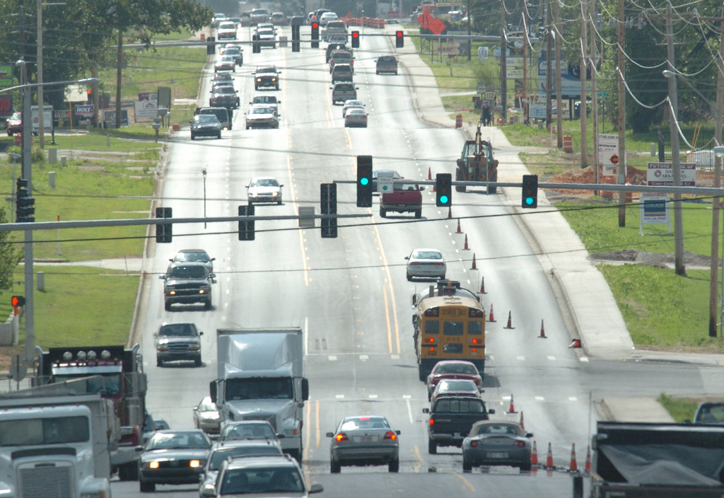
We took a look at one busy road outside of Orlando where a dozen people have been struck and killed by drivers in recent years. The mix of high-speed traffic with people walking, biking, and taking transit is a dangerous combination; in the event of a crash, people die. The Complete Streets Act of 2019 would go a long way to give local government more resources to redesign these dangerous streets so everyone can travel along them safely.

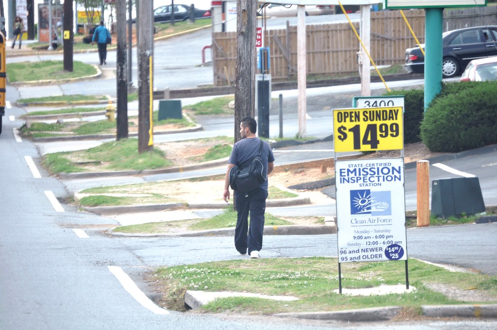
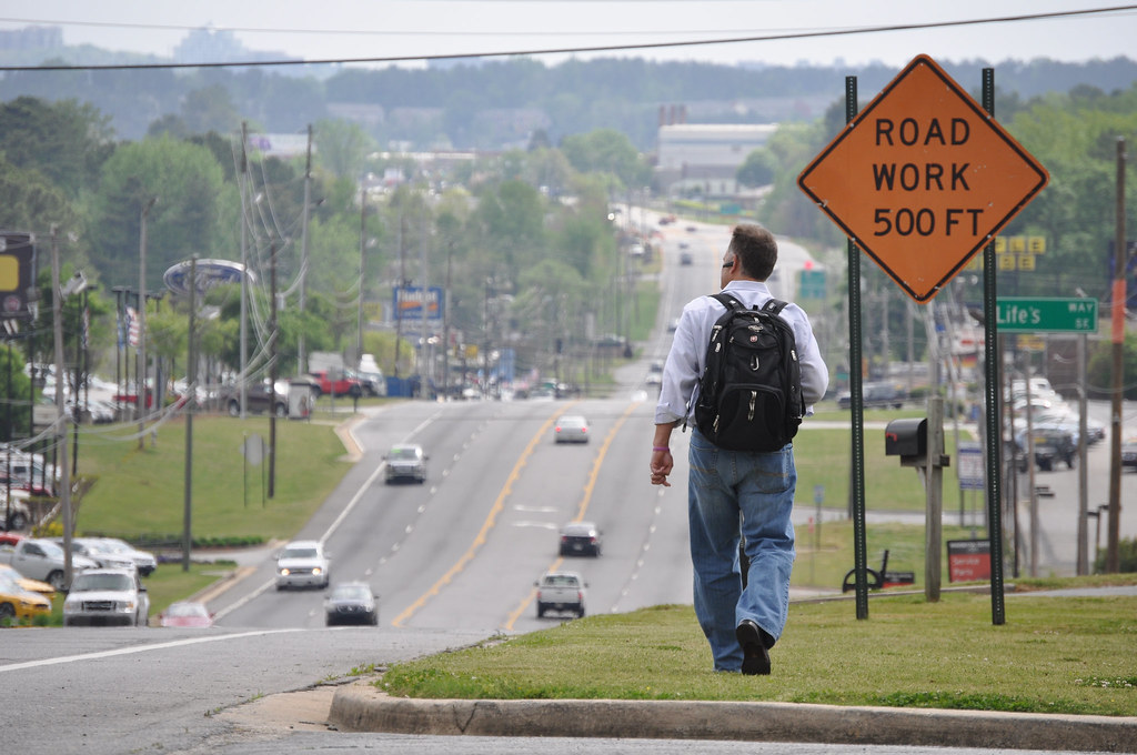
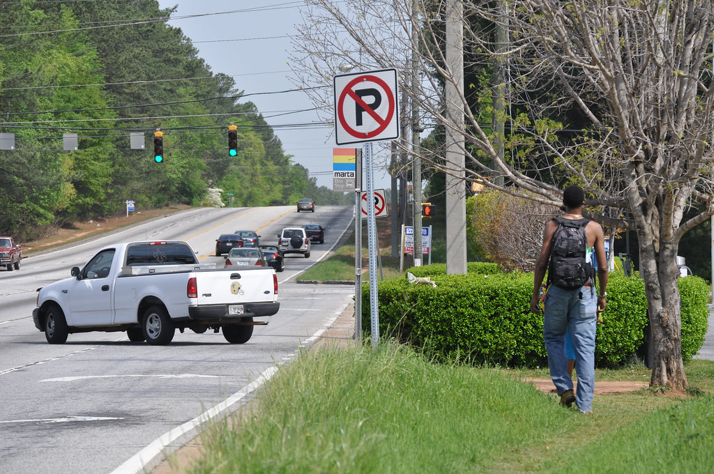
South Orange Blossom Trail isn’t a pleasant path through an orange grove, as the name would suggest, but rather a busy street in the Orange State that runs south from downtown Orlando. South Orange Blossom Trail is like many similar ‘arterial’ roads across the country: grocery stores, places of worship, clothiers, gas stations & auto repair shops, apartments & homes, restaurants, and a multitude of other businesses have sprouted along the route. And like so many similar streets surrounded by development in cities and towns of all sizes, it’s also a death trap for people on foot.

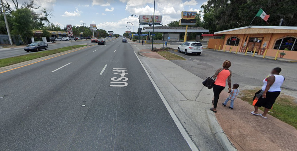
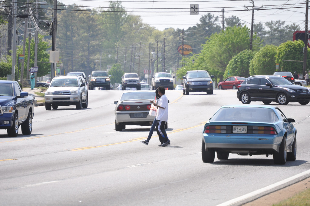
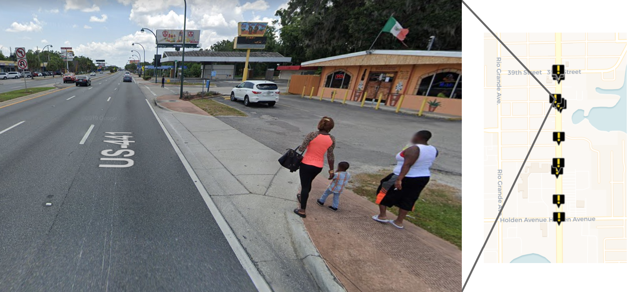
A street view of South Orange Blossom Trail and the location of this image relative to the 12 pedestrian deaths along this stretch of road from 2008 to 2017.

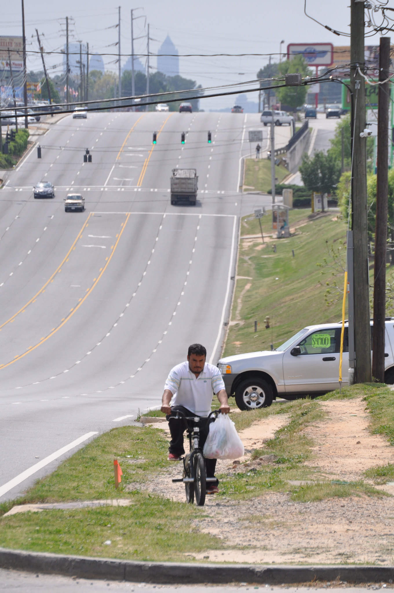
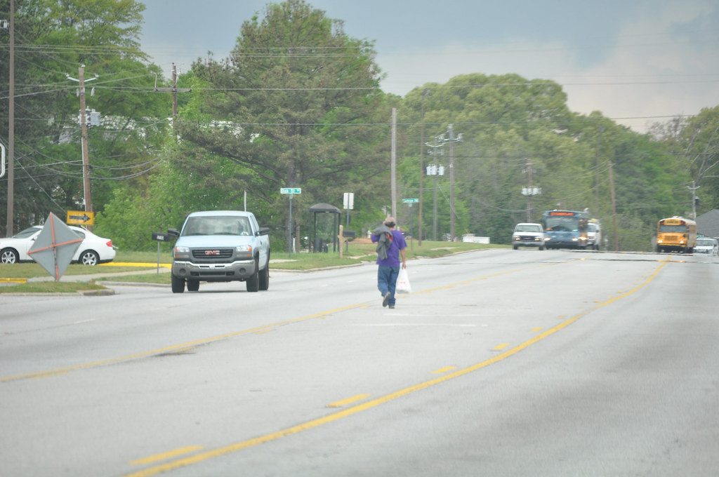
Between 2008 and 2017, 12 people walking were struck and killed by drivers along a 3,400 foot stretch of South Orange Blossom Trail. This six-lane thoroughfare (three lanes in each direction) is a gauntlet for people walking, and with the multitude of shops and homes in the area and bus stops regularly dropping people off on the side of the road, people walking are everywhere.

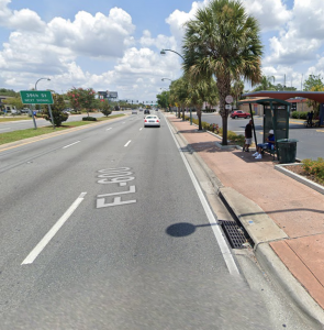
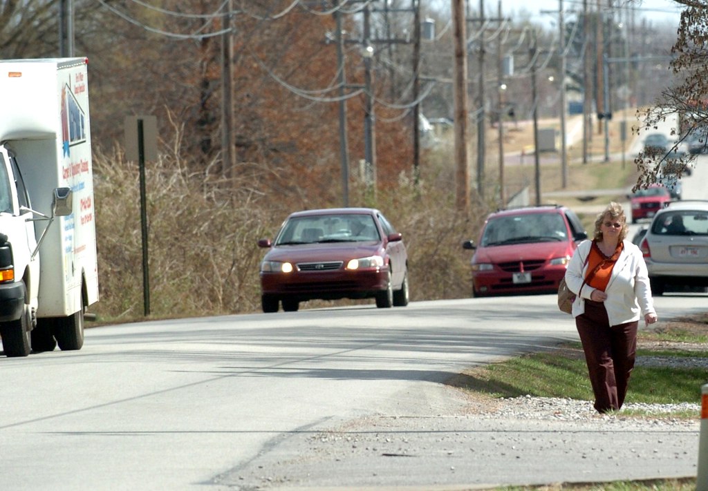
The nearest crosswalk isn’t even visible from this bus stop outside an apartment building.

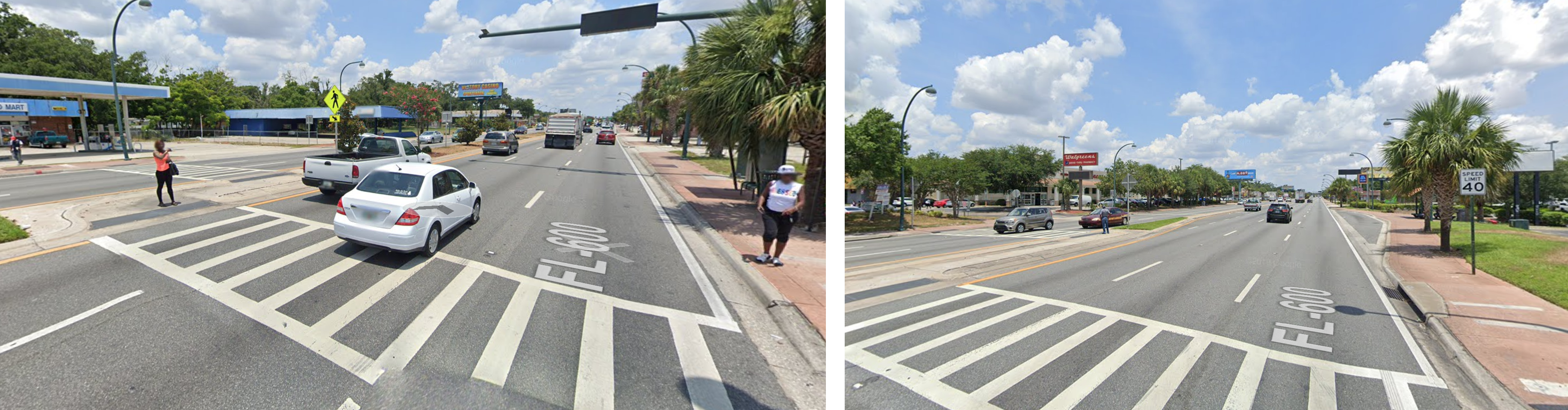
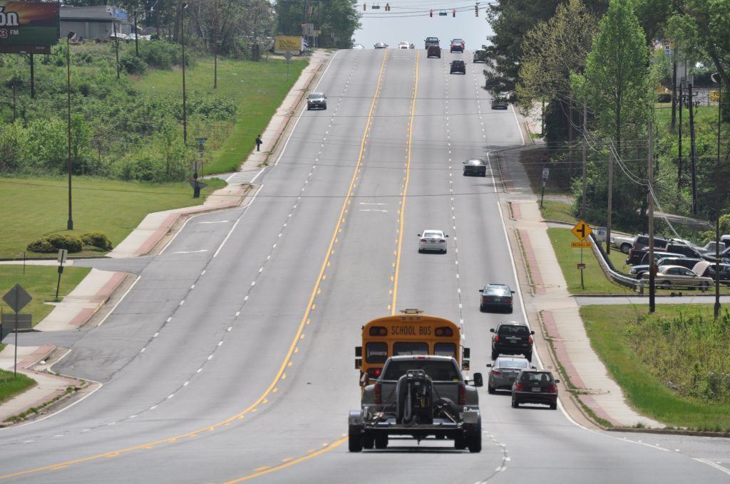
This particular segment has a posted speed limit of 40 mph, but there is absolutely nothing about the design of this road that would encourage drivers to observe that limit. The wide, straight lanes and open skies communicate to drivers that this is a highway and you should thus be driving at high speeds. There are even signs that tell you which intersection you’re coming up on (because you’re certainly driving too fast to see it, as in the picture above). The only two signalized crosswalks along this stretch for pedestrians are at either end, 3,400 feet apart or about a 15 minute walk. While there are some unsignalized mid-block crosswalks, you have to be brave, stupid, or have no other choice to try crossing three lanes at a time hoping drivers going 50+ mph will stop for you. This street was built for speed not safety. It’s no wonder that a dozen people have been killed while walking along it in recent years.

South Orange Blossom Trail is the quintessential example of how U.S. street design standards and a focus on speed above all else have created such dangerous roads and why we have an epidemic of pedestrian deaths in this country. It’s a street designed for speed and to avoid vehicle delay. People walking, biking or taking transit are merely afterthoughts, just guests on this road designed for cars. Simply ask the people waiting to cross in the middle of these six lanes if it feels like this street was designed with someone walking in mind.

two images showing pedestrians attempting to cross the street.

It’s also the quintessential example of a street that the Complete Streets Act of 2019 in Congress is designed to fix. The Complete Streets Act would designate a small slice of federal highway funding to create Complete Streets that are safe for people walking, biking, taking transit, or driving. Any community with a Complete Streets policy—be it a county, city, town, or tribal government—would be able to apply for this funding directly to retrofit dangerous streets with safer designs.

Take action

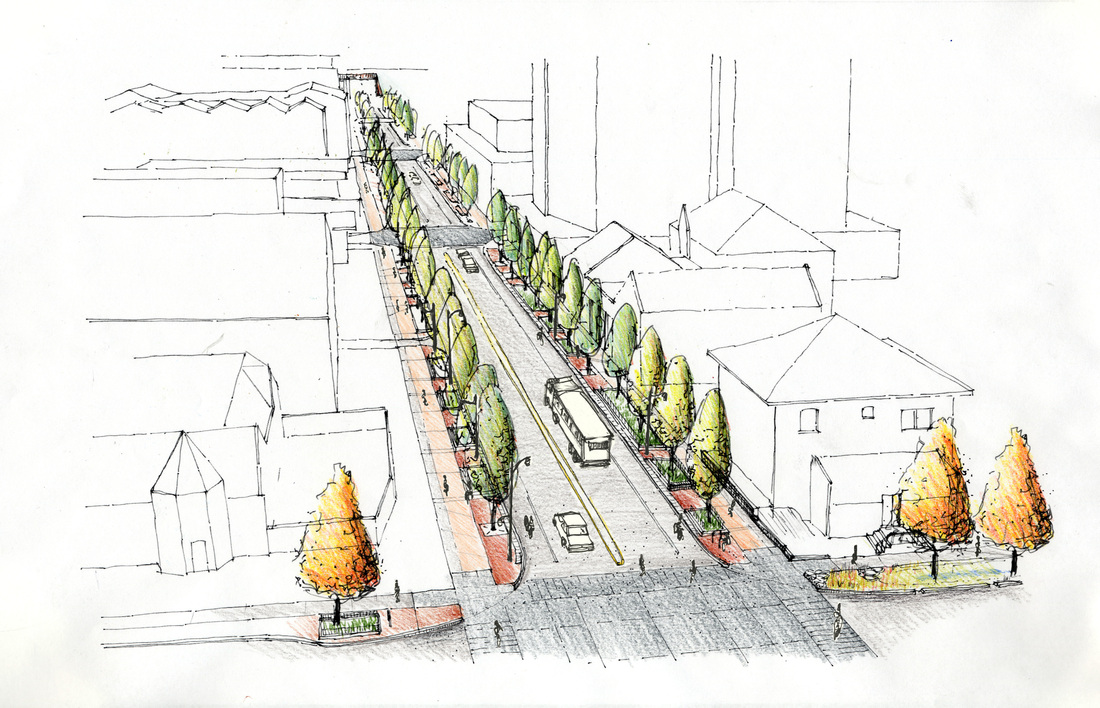
Under the Complete Streets Act, counties could adopt a Complete Streets policy (if one isn’t already on the books) and then apply for dedicated funding to retrofit roads like South Orange Blossom Trail in unincorporated areas. Depending on the context, a safer street could include narrower lanes, protected bike lanes, signals at mid-block crosswalks, street trees, and other design interventions that can help slow cars and make space for different uses. On locally-owned roads, cities and towns could use the same pot of federal funding to implement similar improvements on dangerous roads.

For too long, prioritizing cars going fast above all else has been the top consideration in the design of our streets. It’s how we ended up with dangerous streets that look more or less exactly like South Orange Blossom Trail in all 50 states (even in Alaska, just add mountains along the skyline). According to current U.S. street design standards, this road and its ilk are designed exactly as they should be; that’s the problem.

We have to start putting safety over speed. Safety—literally keeping people alive—is more important than shaving a few seconds off a driver’s commute. And prioritizing safety is fundamentally incompatible with high speeds on these kinds of streets. The Complete Streets Act of 2019 would be a major step in the right direction, if Congress can pass it.

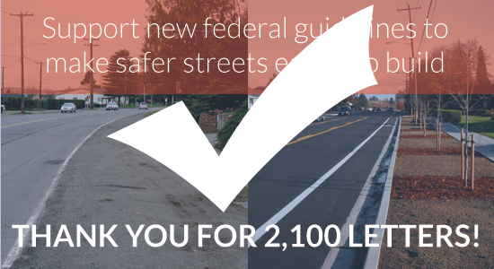
Send a message to your representatives urging them to support the Complete Street Act.

On National Walking Day, too many Americans are still having to endure unsafe streets

Since we missed recognizing National Walking Day last week while the Complete Streets conference was happening in Nashville, we wanted to come back this week and revisit a T4America post from 2012 looking at what’s actually keeping more people from walking in many of our metro areas.

Originally posted on April, 4 2012.

You may not have known it — its not the most publicized special day on the books — but today is National Walking Day. Some of you may have traded part or all of your drive or transit trip today for a walk to work. But for many, every day is walking day, and it happens on streets with dangerous or inconvenient conditions that no one should have to endure just to walk to school, their job, or the grocery store.

Last Friday, I spent some time driving around the sprawling Atlanta, Georgia metroplex photographing some well-known trouble spots for pedestrian safety. Though some improvements have been made in places, there are still so many unsafe streets, corridors and intersections for pedestrians, finding streets that are dangerous by design is about as easy as blindly putting your finger down on a map.

The Atlanta Regional Commission has helped address some of these problems through their popular and oversubscribed Livable Centers Initiative that gives metro communities small grants to help make a dangerous street safer, improve MARTA access, add new crosswalks or streetscaping, or other small improvements to the built environment that help improve quality of life for residents. And the local group PEDS has had their boots on the ground for years now, working hard to make metro Atlanta more walkable. But we need far more of these kinds of efforts — and similar efforts from others in cities across the country — to make the kinds of improvements we need to save lives and end the 4,000-plus deaths that happen to people walking each year.

Many of these deaths occur simply because the design of a road just hasn’t adapted to the changing needs of all the people who use it.

Consider: at one point, Old National Highway in South Fulton County was probably a sleepy state highway through a relatively unpopulated area on ones way south out of Atlanta. Now, its teeming with retail on both sides of the street just south of Interstate 85. Add in the fact that its a relatively low-income area (read: people more likely to walk or take transit) with apartment complexes on both sides of the main highway and you’ve got a street that no longer meets the needs of everyone who uses it, and certainly not for the people who live there.

Metro ATL Pedestrians15

Though the first few miles away from Interstate 85 have sidewalks and there are a handful of signalized intersections with crosswalks, sidewalks soon end completely and there are many stretches where there are no safe places to cross for hundreds or thousands of feet — all in an area with MARTA bus stops on both sides of the highway. The sidewalks may end, but the walking doesn’t, as the desire paths through the grass indicate.

Metro ATL Pedestrians06

Of course, the most well-known road in Atlanta thats dangerous for walking and biking is certainly Buford Highway. This stretch near Clairmont Road is a whopping seven lanes across, with crosswalks often so far apart as to be merely dots on the horizon.

Metro ATL Pedestrians36

This corridor is lined with more affordable apartments and has also been a popular landing place for Latino and Asian immigrants for years, and many portions of the street are filled with small ethnic shops catering to the local clientele — many of whom are likely to be walking. According to the data in our map, in just the few miles from I-285 south down to 400, 20 pedestrians were killed from 1999-2009. There are stretches with no sidewalks on either side of the street and no safe crosswalks almost as far as the eye can see.

Metro ATL Pedestrians41

In this picture alone, not only are there no sidewalks but there are nine separate curb cuts where this man could be easily struck by a right-turning car before reaching the next safe crosswalk at the intersection.

Some key improvements have been made on Buford Highway in recent years, though, which have helped to increase safety. Thanks to recent efforts by Dekalb County and the Georgia Department of Transportation, a busy stretch of Buford Highway south of Doraville with high density of retail on both sides of the street received several new signalized intersections as well as new pedestrian-only mid-block crossings that use a special light called a HAWK signal. This is a light that stays dark until a pedestrian pushes a button, activating a light that flashes before turning red for cars. These crossings also include a refuge to shorten crossing distances and give people a safe place to wait while crossing.


And then there’s southern Cobb County, the northern Atlanta suburb where Raquel Nelson was walking when her son was killed and she found herself prosecuted after the fact. Some busy corridors have sidewalks and some don’t — though walking isn’t very pleasant next to seven lanes of traffic — and crosswalks can be interminably far apart.

Metro ATL Pedestrians24

This photo below bears some similarities to the conditions on the street where Raquel Nelson’s son A.J. was killed, which isn’t too far from here.

Metro ATL Pedestrians21

Note the bus stop on the other side of the street with a Cobb County bus approaching. See a marked crosswalk anywhere? Perhaps this man is trying to catch the bus? What happens when the bus drops you off and you need to reach a destination across the street? Should we really expect people to walk half a mile out of the frame to find a safer place to cross, and then walk half a mile back?

And some streets around here just have zero accommodation for pedestrians, including a busy street that serves two major universities and the county’s biggest employer (Dobbins AFB/Lockheed) right in the center of the county.

Metro ATL Pedestrians26

Keep in mind that these pictures represent just one busy American metropolis — there are hundreds more cities and thousands of places with similar conditions that need urgent attention. We have a long way to go to retrofit these streets to help make them safer for everyone that needs to use them. The complete streets provision in the Senates MAP-21 bill would be a step in the right direction, as would be the flexible funding that local governments can use to help address some of these dangerous areas under the Senate bill. (These provisions are a little out of date now. -Ed.)

With 67 percent of all pedestrian fatalities happening on federal-aid roads — many of which that were designed in this unsafe way because of federal design guidelines and standards — theres a clear role for the federal government to play in improving them.

So what would happen in our communities if we started by looking at our map of pedestrian fatalities to see where the worst trouble areas are and devoted a small slice of transportation money into small, tangible improvements like new sidewalks, new crosswalks, and new signals for making walking safer and more convenient? What if we made it a clear priority to make every day National Safe Walking Day?

Wouldn’t we be saving lives immediately? And for a small price?

TIGER grants focus on rural areas, recognize the value of complete streets, and ignore transit

Just a month after the Trump administration proposed a budget that would eliminate the competitive TIGER grant program entirely next year, the US Department of Transportation announced the winners of this year’s awards. This year’s winners show a clear shift in priorities — this round is decidedly rural or small town in nature and nearly devoid of transit projects. However, the winners also show that this administration recognizes how smaller-scale complete streets projects bring tremendous value to local communities.

The fiercely competitive but notably small TIGER grant program is one of the few ways that local communities of almost any size can directly receive federal dollars for their priority transportation projects. The federal government has found a smart way to use a small amount of money to incentivize the best projects possible and encourage local investment: TIGER projects brought 3.5 other dollars to the table for each federal dollar awarded through the first five rounds. They’re overwhelmingly multimodal and multi-jurisdictional projects—like rail connections to ports, complete streets, passenger rail, and freight improvements—that are often challenging to fund through the traditional, narrow transportation formula programs.

This intense competition for funds stands in stark contrast to the majority of all federal transportation dollars that are awarded via formulas to ensure that all states or metro areas get a share, regardless of how they’re going to spend those dollars. And unlike the old system of congressional earmarks, the projects vying for funding compete against each other on their merits to ensure that each dollar is spent in the most effective way possible.

As we look through this year’s list of awardees—the ninth group of winners since the program was created in the stimulus package of 2009—five clear themes rise to the top. Here’s what you need to know about this year’s TIGER winners and the status of this valuable program.

#1 Reminder: this could be the last of the TIGER program

Though it’s one of the most fiscally responsible transportation programs administered by USDOT and incredibly small when compared to the overall transportation program, the administration’s budget request for next year completely eliminates TIGER. While the Senate has stepped in to save this program numerous times, they’ll only continue to act if the local leaders who depend on it continue to speak up.

Whatever the pros and cons of the winners, as outlined below, local officials across the country depend on this program to invest in ways that traditional state or federal programs either don’t allow or make too difficult. Once again, this round is full of projects that would have been unlikely to receive funding under the traditional program either due to the project type or project sponsor.

#2 The administration rewards the growing local support for complete streets and main street revitalization

If there’s a clear winner in this round of awardees, it’s for projects that are focused on revitalizing main streets, improving pedestrian safety and access to transportation options, and building a better street framework for creating and capturing value. Projects in Carson City, NV; Immokalee, FL (pictured in graphic above); Burlington, IA, Akron, OH; Frankfort, KY; and Mill City, OR, among a few others, all have a strong complete streets or bicycle and pedestrian component. The administration is to be commended for seeing the connection between investing in traditional, people-focused streets and downtowns as not only a viable economic development strategy, but a vital one.

But the administration can’t choose these projects if they’re not in the applicant pool. And the proliferation of these projects is a testament to the growing movement of local officials who understand that improving safety through low-cost interventions, building a sense of place, investing (or reinvesting) in downtown, and focusing on moving people rather than just vehicles brings a strong economic payoff to their communities. Because of that, they’re investing their own dollars heavily in these projects and the administration is making a wise investment by partnering with them.

#3 More funding for rural projects, but with a loose definition of “rural”

While USDOT says that over 60 percent of the awards go toward rural projects—a stated goal of the Trump administration—it’s probably more accurate to say that most of this funding goes to midsized cities. (They count places like Lincoln, NE—pop. 280,000—as rural.) There was also a clear bias in favor of awarding funds to projects in states that are in the middle of the pack in population, and the most populated states that produce an outsize share of the country’s GDP mostly received very low dollar awards—states like California, New York, Texas, and Illinois.

While funding more “rural” projects is a stated goal of the administration, it’s hard to square with the administration’s current plans to make towns and cities and states pick up more of the funding burden. Rural projects usually bring less local or state money to the table, by DOT’s own admission“Since 2009, the TIGER program has awarded nearly $1.4 billion in federal funding to 171 rural projects across the nation, leveraging an estimated $2.5 billion in non-TIGER funding,” lower than the 3.5 non-federal dollars per TIGER dollar for all projects through the first five rounds. In an ironic twist, these smaller places (and midsized cities, as noted) will be the ones most intensely feeling the squeeze if the administration gets their way on federal transportation funding.

#4 Awards for transit projects were few, keeping with the administration’s overall views on transit

The underlying law’s language (found in the 2017 appropriations bill) requires some level of parity between various modes of transportation:

“…the Secretary shall take such measures so as to ensure an equitable geographic distribution of funds, an appropriate balance in addressing the needs of urban and rural areas, and the investment in a variety of transportation modes”

Contrary to that language in the law, this batch of TIGER grants only includes a few smaller transit projects, leaving out both the quantity and size of larger transit investments we’ve seen in many past rounds. Though it’s not in step with the intention of the program as crafted by lawmakers, it’s certainly hand-in-glove with the administration’s stated belief that localities should fund transit investments all by themselves. The administration has already pledged to end the capital program for building new transit lines or stations, and these awardees largely reflect that view.

#5 The tradeoff for a project in almost every state is the lack of nationally significant projects

It’s nearly impossible to make an award in almost every state while also funding a handful of larger, transformative, nationally significant projects—projects like the CREATE program (rounds I and IV) to address huge national freight rail bottlenecks in Chicago or the Crenshaw/LAX Light Rail project. This has been a struggle for the TIGER program dating back well into the Obama administration, but this is the tradeoff that comes with trying to get an award for nearly everyone: more smaller awards, and less capacity to invest in big nationally significant projects that have benefits for people far outside of a single city, region or state.


TIGER should represent a way forward

The majority of all federal transportation dollars today are awarded to states and metro areas in a way to ensure everyone gets a share, regardless of how they’re going to spend those dollars or how well-conceived their projects are. TIGER operates differently, forcing projects to compete against each other on the merits. Rather than being slated for elimination, this should be a model for the future of transportation funding: formula dollars awarded for repair and maintenance, and then money for any new capacity (of any type) awarded competitively.

Will Congress acquiesce to the administration’s demands to eliminate TIGER? In spite of the administration’s stated opposition to this program, they just funded 41 important projects that would have been difficult to build under the regular program. As stated above, Congress will only continue defending this program as long as local leaders and advocates continue pressing for its survival. Get in touch with your representatives today and urge them to continue supporting this small but vital program.

Join us for the only national conference about arts, culture and safer street design

Smart Growth America’s arts and culture team and National Complete Streets Coalition, now in partnership with the Urban Land Institute, invite you to the only national conference focused on the intersection of arts, culture, and building safer, complete streets.

On April 3 and 4, in Nashville, TN, Intersections will bring together planners, artists, engineers, public health advocates, and many others to collaborate and find practical ways to integrate arts and culture to create streets that are not only safe for everyone, but also better reflect the unique character of their communities.

The arts and culture connection to Complete Streets

We believe that everyone in America—no matter their age, ability, income, or race—deserves the option to live somewhere affordable, convenient, beautiful, and safe. Our arts & culture team funds pilot projects, supports local and regional partners, and conducts research that shows that art and culture play a crucial role in supporting this vision by providing an organizing force for residents, business owners, and other stakeholders to work towards strengthening neighborhoods, by revealing the authentic character of communities, and by connecting citizens with decision makers to collectively pursue smart, equitable policies and projects.

Whether you’re an artist or an engineer, join us in Nashville to learn more about these vital connections.

The brand new conference website makes it easy to access everything you need to know about Intersections, with new speakers being added regularly. Registration is open, and you can purchase a ticket at the discounted rate of $195 (regularly $250) from now until 11:59 p.m. EST on January 31st by using the promo code: new year_new intersections.

In partnership with the Urban Land Institute

To bring this conference to the next level, we are partnering with the Urban Land Institute to expand conference offerings and explore how to transform vehicle-dominated commercial corridors to better serve those who live, work and travel along them. ULI will bring expertise gained through their Healthy Corridors project to understand the common issues facing commercial corridors that impact the social determinants of health, and how these corridors can be transformed to become safe, healthy,vibrant, mixed-use places.

Full agenda coming soon

The conference will start at 7:30 a.m. on Tuesday, April 3rd with registration and breakfast and end at 6:00 p.m. on Wednesday, April 4th. Both days will be held at the Music City Center in Nashville, TN. 

Speakers and panel sessions are being added regularly to the website. Click here to learn more about experts, advocates and practitioners from around the country who will be at the conference. The agenda will be packed with two full days of interactive panels, and breakout discussions about cutting-edge Complete Streets, healthy corridors, and creative placemaking research, ideas and practices.

See you in Nashville!

Thank you to our sponsors:

Stories You May Have Missed – Week of August 25th

Stories You May Have Missed

As a valued member, Transportation for America is dedicated to providing you pertinent information. This includes news articles to inform your work. Check out a list of stories you may have missed last week.

  • President Trump has dropped plans to form an infrastructure council that would have advised him on the infrastructure plan his administration is putting together. (Bloomberg)
  • “The Trump administration is seeking input from rural communities around the U.S. as it assembles a $1 trillion infrastructure package.” (The Hill)
  • The U.S. Senators from New Jersey and New York have called on U.S. DOT to revisit their plan to withdraw a proposed regulation to test rail and truck operators for sleep apnea. (Progressive Railroading)
  • Our partners, the National Complete Streets Coalition (NSCS), did a question and answer session with a board member of the National Transportation Safety Board (NTSB) on their new report documenting that 31% of all deaths on our roadways are due to speeding. The report provides recommendations on how to reduce deaths. (NCSC, Streetsblog)
  • Asset Recycling an Alternative Approach to P3s. Learn more about the practice of selling or leasing existing, publicly-owned infrastructure and using the proceeds to pay for building or maintaining other infrastructure. Read T4A member summary here.

Help show just how dangerous our streets can be for people walking

This fall, our colleagues at the National Complete Streets Coalition will release Dangerous by Design 2016, a report that will again rank the nation’s most dangerous places to walk using the Pedestrian Danger Index. This year’s report will dive deep into how income, race, and place play an outsized role in how likely people are to be killed while walking. And they’re looking for your help when it comes to illustrating just how bad it can be out there.

For too many people, a walk is a deadly risk. Poorly designed streets have led to an epidemic of pedestrian fatalities, especially among people of color and in our nation’s poorest neighborhoods. More than likely, one of these dangerous streets or intersections is near you or is one you have to use every day. When T4America last released a version of this report back in 2011, we had powerful photos submitted from all over the country.

Help illustrate the hazards you face everyday by expanding upon those photos previously submitted. Send in photos of streets in your neighborhood that are “dangerous by design.” Streets like these:

Metro ATL Pedestrians06Metro ATL Pedestrians41Walking in the ditch

Poorly designed streets like these above — often built or designed with federal dollars or guidelines — endanger pedestrians, cyclists and drivers alike. And as this latest edition of Dangerous by Design will expand upon, people of color and census tracts with below average income are disproportionately represented.

Here’s how you can help:

  • Send in photos via email to photos@completestreets.org.
  • High resolution photos are preferred for maximum quality.
  • Please indicate how photos are to be credited if used online or in the report.
  • Provide information about the photo. Where was the photo taken? Is this a street that you have to use regularly?

We want to see the missing crosswalks, missing curb ramps, and the long and dangerous treks along busy highways. We want to see every way that our current road designs have failed to provide for the safety and convenience of everyone that needs to use them. Help show just how difficult and dangerous we’ve made walking for so many people. The NCSC folks are preparing the report now, so pass them along soon!

Webinar wrap: How MPOs are prioritizing public health to build prosperous regions

Last week, we had a terrific online discussion detailing how public health professionals are working with regional transportation planners to plan, fund, and support building more state of the art active transportation projects — accompanying the release of Measuring What We Value: Prioritizing Public Health to Build Prosperous Regions.

For this webinar, we were joined by staff from the American Public Health Association, the Centers for Disease Control and Prevention, and metropolitan planning organizations from the regions of Broward County, Sacramento, Greensboro, and Nashville.

Did you miss last week’s webinar or want to see it all again?

Stay tuned for more information targeted at MPO staff, public health professionals and local advocates on how to work with regional transportation planners to plan, fund, and support building more state of the art active transportation projects.

CDC APHA health case studies


Metropolitan planning for healthier, safer, more prosperous regions

How can metro area planning agencies strengthen the local economy, improve public health outcomes for all of their residents, promote social equity and better protect the environment? Join us to hear the stories of how a handful of metro areas have found smart, data-driven ways to better conceive, select and build the transportation projects that will help meet those regional goals.

Flickr photo by the Broward MPO. /photos/speakupbroward/24986492294

Flickr photo of an event by the Broward MPO. /photos/speakupbroward/24986492294

Metropolitan planning organizations (MPOs) not only have responsibility to create regional plans that govern federal spending within their borders, but those in larger regions also control a limited amount of transportation funds directly. How they manage these responsibilities has a huge impact on the health of their residents and their access to jobs and other opportunities.

Can the people in neighborhoods more likely to be unhealthy easily get out for a walk or bike ride without having to traverse dangerous streets? Does an MPO effectively consider the impacts on regional air quality as they choose which projects to build? Is the area putting forward the most competitive possible walking and biking projects to win limited state or federal funding?

We’re excited to bring you the stories of a handful of MPOs that have good answers to all of these questions next week via a new series of short case studies and an accompanying webinar on Thursday, September 22 at 1 p.m. EDT. Register for the webinar with the link below.

REGISTER NOW


Register for the webinar and you’ll be the first to receive a copy of these new case studies. If you work for an MPO, advocacy group or health organization and want to learn about ways to increase or improve the quantity and quality of active transportation projects in your region, this one is for you.

The MPOs we’re featuring have found ways to better use data and modeling tools to win funding for active transportation projects, standardize the process for building safer, more complete streets, or promote health and economic prosperity through transparent, data-driven decision-making. And we’re excited to share their stories with you.

On the webinar, we’ll have a short conversation with staff from four MPOs featured in the case studies. They’ll share details on their policies and programs, the transportation projects that resulted and the partnerships they had to forge to taste that success.

Join our team and experts on September 22nd at 1pm EDT. Register today!


Development of the case studies featured in this webinar was made possible through a contract between the American Public Health Association and Transportation for America funded through cooperative agreement 5U38OT000131-03 between the Centers for Disease Control and Prevention and the American Public Health Association.  The contents of this document are solely the responsibility of the authors and do not necessarily represent the official views of the American Public Health Association or the Centers for Disease Control and Prevention.

Copy this strategy: CUMTD wins TIGER grant, assisted by T4A Technical Assistance program

Champaign-Urbana’s leaders are clear on what they want for their future: a progressive environment with urban amenities while maintaining small city affordability. To achieve that vision, the region is pinning its future on the transformation of a few key corridors that connect the cities of Champaign and Urbana with the University of Illinois’ flagship campus in Champaign, IL. While this effort will consist of many projects over a number of years, Transportation for America Technical Assistance partnered with the lead agency to secure a substantial and important federal TIGER grant, jumpstarting the project.

Success and its challenges

Since the 1990’s, regional leaders have charted future development to be denser, greener, and provide more transportation options. Over that time, transit ridership has increased and more people are biking and walking. But the confluence of pedestrians, bicyclists and drivers can mean a chaotic atmosphere, especially during events or when school is in session. “There are a lot of conflicts between bikes, pedestrians, buses and cars,” said Dave Clark, City Engineer for the City of Champaign.

Heavy pedestrian traffic at the intersection of Wright and Armory Streets.

Heavy pedestrian traffic at the intersection of Wright and Armory Streets.

These conflicts can be dangerous and city planners realized that their solutions would need to take into account not just the safety of their residents and visitors, but also the livability and affordability of the region. “The streets really needed repair,” said Jane Sullivan, sustainability planner for the Champaign-Urbana Mass Transit District (CUMTD) “but we didn’t just want to pave over them and leave the same problems.”

The solution

In order to achieve these multiple goals, CUMTD approached the cities of Champaign and Urbana to work collaboratively and transform the two-lane roads along the downtown corridor to complete streets that prioritize pedestrians, bicyclists, and transit users. Ultimately, this became known as the Multimodal Corridor Enhancement (MCORE) project. MCORE consists of five individual street projects and centers on Wright Street, the street dividing Champaign and Urbana. This is where the hub of the campus transportation system meets Green Street, the heart of Campustown for the University of Illinois and its entertainment, shopping, and cultural center. As Dave Clark noted, the campus is “directly sandwiched between Champaign and Urbana’s respective downtowns and over 80% of the region’s jobs are located within a mile of the thoroughfare.”

The rendering of what Green Street will look like when completed.

The rendering of what Green Street will look like when completed.

Using a complete streets approach to accommodate all modes of travel (bus, pedestrian, bike and vehicles), each street will undergo either full reconstruction or major rehabilitation, transforming each into a multimodal corridor that better serves everyone who uses the street. In addition to the road improvements, other project benefits will be improved bus capacity and frequency on these key bus routes; improved sidewalks, new street lighting and the addition of on-street bicycle lanes.


Third time’s the charm

In order to make this ambitious project happen, CUMTD applied for USDOT’s highly competitive TIGER program twice before but, had struck out in both attempts. The third time, CUMTD turned to Transportation for America Consulting to help develop a strong grant application and organize support from Illinois’ congressional delegation — the latter of which was crucial for a successful application.

“It was very important that both cities & the university were involved in the application and able to commit time and funding”, said Sullivan, who also manages CUMTD’s grants. “We knew this wouldn’t work unless all partners were supportive and able to make the investment.” In 2014, with T4America Consulting’s help, the group of local agencies finally won a $15.7 million TIGER grant to rehabilitate and redesign these busy, crucial streets to safely accommodate all roadway users.

Partnership pays off

“This project is a great example of the municipalities, the CUMTD and the University working together to maximize their leverage to accomplish infrastructure needs for all,” said Michael DeLorenzo, associate chancellor for the University. “It is a true local partnership, with the assistance of our Congressional delegation, which has enabled us to get the resources necessary to make this possible.”

The project is expected to spur additional development and increase accessibility in some areas where transit-oriented development is already occurring. It will be easier and safer for people to get around whether they are on foot, bike, transit or driving. “Pedestrians and bicyclists and transit users will get to see and feel the experience of feeling safer and more comfortable” said Sullivan, “and I think even more people will be willing to walk, bike, and take transit.”

TIGER supports neglected local needs

The MCORE project is a great example of how direct federal investment to communities can incentivize local partnerships and fund smart, homegrown transportation projects to solve locally identified issues. White reinforces this:

“So often, federal dollars are spent on the bare minimum for highways and bridges, and aren’t spent on the projects that are closest to the people, the communities. The state DOT focuses on its own bridges & roads, different jurisdictions operate in their own silos, and then the systems in our cities are not integrated. The TIGER program smashes those silos, providing an incentive to collaborate and look at the most sustainable and effective solutions.”

“The TIGER model just works better,” White says, “because it demands cooperation and allows communities to focus on the solutions that work for them.” In Champaign-Urbana, collaboration through the TIGER-funded MCORE project will help all members of the community get around more safely, quickly, and conveniently, helping to bring local partners even closer together.

Transportation for America has long supported the federal TIGER program and continues to do so in this year’s appropriations process. This year, T4A—in partnership with over 170 elected officials and local, civic, and business leaders from 45 states—sent a powerful message to congressional appropriators that the competitive TIGER and New Starts programs are crucial to local economic prosperity and competitiveness. Of note, the letter urged Congress to include at least $500 million for TIGER transportation grants. Congressional appropriators listened, with the US Senate providing $525 million for TIGER and the US House providing $450 million in their respective FY2017 T-HUD bills.

If you are interested in how Transportation for America Technical Assistance can support you and your community in creating better, more livable communities; please contact Erika Young, Director of Strategic Partnerships at Erika.young@t4america.org.

Feds get out of the way of communities that want to design safer, more complete streets

The Federal Highway Administration made two big moves this last week to clear the way for states, metro areas, and local communities to use federal dollars to design safer, more complete streets.

atlanta highway local street

Good news: old federal street design guidelines that often required local streets to be designed like this have been radically scaled back.

Both of these updates are great news for anyone advocating for streets that better meet the needs of everyone that uses them, as well as better serving the goals of the surrounding community. FHWA deserves a big round of applause for making these changes.

If you are working on a local transportation project and your DOT or some other agency cites vague federal rules when refusing to build a safe and complete street, show them the FHWA memo below. Their guidance makes it extremely clear: there’s wide latitude to design streets to best suit local needs, and old regulations that treat all roads like highways have been rolled back. 

Federal street design guidelines just got a lot simpler

Last week, FHWA finalized new street design guidelines that eliminated most of the criteria that local communities and states must adhere to when building or reconstructing certain roads — especially those with speed limits under 50 mph. Of 13 current design criteria for certain roads under 50 mph, 11 criteria have been scrapped, because, in FHWA’s words, they have “minimal influence on the safety or operation on our urban streets.”

Until now, states or cities would have to go through an arduous process of requesting an exception to do common sense things like line a downtown street with street trees, reduce the width of lanes to add a bike lane, or curve a street slightly to slow traffic and make it safer for people in cars and on foot. (This old post explains the change in more detail.)

Tfhwa design guidlines thank you
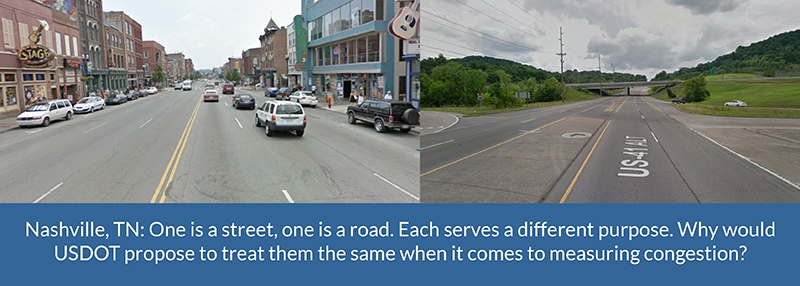
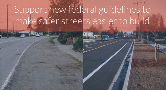
he new criteria recognize that successful streets running through a bustling downtown of any size need to be designed far differently than rural highways connecting two towns or cities. They have to meet a far more diverse range of needs than simply moving cars fast, and these smart new guidelines reflect that wisdom.

Thousands our supporters sent in letters to FHWA on this issue, and FHWA listened. From the final rule:

The FHWA received comments from 2,327 individuals and organizations on the proposed changes to the controlling criteria. Of these, 2,167 were individual form-letter comments delivered to the docket by Transportation for America. …The overwhelming support for changes to the controlling criteria indicate that the changes will support agency and community efforts to develop transportation projects that support community goals and are appropriate to the project context. The provisions included here for design documentation will result in more consistent evaluation of exceptions to the adopted design standards when controlling criteria are not met on NHS highways.

Even more encouraging, FHWA responded strongly to the handful of state DOTs that sent in comments noting their desire to keep the old design guidelines intact.

The FHWA finds that removing these controlling criteria from application in low-speed environments is supported by research and provides additional flexibility to better accommodate all modes of transportation. No new controlling criteria are proposed at this time.

In their comments, FHWA affirmed that local communities should have more leeway in how they design streets — after all, they know their local needs best — and that research shows that the old guidelines made it more difficult to accommodate all modes of transportation.

Vehicle speed- and delay-focused “level of service” metric is not a federal requirement

When planning a new street, reconstructing an old street, or conducting traffic studies for new development, most transportation agencies rely on a metric known as level of service or “LOS”. While commonly accepted amongst many traffic engineers, it’s an outdated, narrow metric that assesses how well a road performs only by looking at the number of cars and the amount of delay experienced by vehicles.

If the only goal of your community’s streets is moving cars fast, then level of service is the way to go. If your community also wants to keep people safe, or allow people to walk, bike or take transit, or support a vibrant downtown, then relying only on level of service isn’t going to cut it. It’s like trying to decide if a new pair of pants will fit by measuring the waist and ignoring the inseam.

Similar to the street design requirements that FHWA just scrapped, level of service is often used to halt plans to make streets safer for everyone or boost economic development by narrowing lanes, adding bike lanes, mid-block crosswalks, bulb-outs, or other improvements. It’s even been cited as a federal requirement in some cases. To those agencies, planners and engineers, FHWA made an announcement on May 6: (emphasis added.)

We have received several questions regarding the minimum level of service (LOS) requirements for projects on the National Highway System (NHS).

FHWA does not have regulations or policies that require specific minimum LOS values for projects on the NHS. [National Highway System] The recommended values in the Green Book are regarded by FHWA as guidance only. Traffic forecasts are just one factor to consider when planning and designing projects. Agencies should set expectations for operational performance based on existing and projected traffic conditions, current and proposed land use, context, and agency transportation planning goals, and should also take into account the input of a wide cross section of project stakeholders.

This might seem like a minor clarification, but FHWA just gave the green light to localities that want to implement a complete streets approach. By making clear that there is zero federal requirement to use level of service (and that there never has been), FHWA is implying that transportation agencies should consider more than just traffic speeds when planning street projects.

Changing policy is one thing but changing behavior is another, however. Level of service is an instructive example. It’s never been a federal requirement, but that hasn’t stopped transportation agencies all over from relying on it. And though the design guidelines have been radically pared back for most streets, that doesn’t mean that a state DOT won’t continue to adhere to them as a matter of course.

Engaging with your city, metro planning organization and state DOT will continue to be important for your community to realize its plans for safer, complete streets.

Yet, USDOT is going the opposite direction on measuring congestion

Of course, these encouraging changes from FHWA stand in sharp contrast with USDOT’s narrow, vehicle-focused proposal for how to measure congestion. While FHWA acknowledges that “traffic forecasts are just one factor to consider,” the proposed rule from USDOT would measure congestion in a way that places vehicle speed and delay far above any other factors.

This would penalize places that have made it easier to avoid congestion by making it easier to get around on transit, by foot or bike, or through telecommuting. And it would have the effect of rewarding places with long commutes that move quickly over places with shorter average commutes that move slower.

We need to measure congestion in a way that lines up with these two very encouraging moves from FHWA.

Have you sent a letter yet? Join the nearly 2,000 people who have already told USDOT they can do better.

Nashville street comparison

Find out who made the “Best Complete Streets Policies of 2015” list tomorrow (4/12)

More than 80 communities passed Complete Streets policies in 2015, and these policies are some of the strongest and most effective ever passed. Which policies stood out as the best? Find out tomorrow when Smart Growth America’s National Complete Streets Coalition unveils the annual ranking of the best Complete Streets policies in the nation.

best-cs-policies-2015-blog-banner

Guadalupe Street in Austin, TX. Austin had one of the highest-scoring policies of 2014. Which communities will be on the 2015 list? Photo courtesy of the City of Austin.

Crossposted from Smart Growth America and the National Complete Streets Coalition

Notably this year, one community scored a perfect 100 on their Complete Streets policy. In the near decade that we have been tracking policies, this is the first time a community has achieved a perfect score. Which community passed the perfect policy? Join us for the launch of this year’s rankings to find out.

To kick off this year’s rankings, join us for an online discussion on Tuesday, April 12, 2016 from 1:00-2:00 PM EDT. This event is free, but registration is required. Webinar registrants will also be the first to get a copy of this year’s rankings, bright and early tomorrow morning. Register today for tomorrow’s kickoff event.

WHAT: Announcing “The Best Complete Streets Policies of 2015”
WHEN: Tuesday, April 12, 2016, 1:00-2:00 PM EDT
WHO: National Complete Streets Coalition staff, leaders from communities with top-scoring policies, and additional special guests
Share this on Twitter
Share this on Facebook

Join the event to find out which community scored a perfect 100, learn how communities create top-scoring policies, and understand what your community can do to craft an outstanding policy of its own.

2015 Complete Streets contenders

82 communities passed Complete Streets policies in 2015 and were included for consideration in this year’s rankings. They are:

Fairbanks, AK
Fairbanks Metropolitan Area Transportation System, AK
North Pole, AK
Hot Springs, AR
Little Rock, AR
San Mateo, CA
Moraga, CA
Stamford, CT
West Hartford, CT
Cape Coral, FL
Longwood, FL
Naples, FL
Orlando, FL
St. Petersburg, FL
Gainesville, GA
Savannah, GA
West Des Moines, IA
Windsor Heights, IA
Carbondale, IL
Park Forest, IL
La Porte, IN
South Bend, IN
Vincennes, IN
Dry Ridge, KY
Grant County, KY
Independence, KY
Taylor Mill, KY
Ashland, MA
Beverly, MA
Framingham, MA
Hudson, MA
Lynn, MA
Longmeadow, MA
Natick, MA
Northampton, MA
Norwell, MA
Weymouth, MA
Middleville, MI
Mount Pleasant, MI
Portage, MI
East-West Gateway Council of Governments, MO
Pagedale, MO
St. Louis, MO
Mississippi Gulf Coast Metropolitan Planning Organization, MS
Oxford, MS
Glendive, MT
Polson, MT
Greensboro Urban Area Metropolitan Planning Organization, NC
Raleigh, NC
Omaha, NE
Keene, NH
Swanzey, NH
Asbury Park, NJ
Bound Brook, NJ
East Amwell, NJ
Hamilton, NJ
Monroe, NJ
Moorestown, NJ
Northfield, NJ
Somerville, NJ
Albuquerque, NM
Bernalillo County, NM
Mid-Region Council of Governments, NM
Auburn, NY
Chautauqua County, NY
Sodus Point, NY
Owasso, OK
Reading, PA
Myrtle Beach, SC
Sioux Falls, SD
Tennessee Department of Transportation
East Ridge, TN
Battle Ground, WA
Mabton, WA
Sunnyside, WA
Toppenish, WA
Wapato, WA

Complete Streets policies—including laws, resolutions, executive orders, policies, and planning and design documents—encourage and provide safe access to destinations for everyone, regardless of age, ability, income, ethnicity, or how they travel.

The Coalition evaluates policies based on 10 policy elements, including the policy’s vision, the project types included, and next steps for implementation, among others. Ogdensburg, NY had the nation’s highest-scoring policy in 2014.

More than 830 jurisdictions at the local, regional, and state levels have now enacted Complete Streets policies—a remarkable feat considering that a mere 33 policies were in place a decade ago. Join us on April 12 to celebrate the best policies of 2015 and safer, more convenient streets that work for everyone.

2,100 letters delivered to FHWA in support of easing restrictive street design regulations

Earlier this week, with our partners at the National Complete Streets Coalition, we delivered nearly 2,100 letters to FHWA supporting their proposal to ease the onerous federal design standards that make it needlessly difficult for local communities to build safer, more complete streets.

Complete Streets director Emiko Atherton

National Complete Streets Coalition director Emiko Atherton on her way to FHWA in Washington, DC earlier this week.

It was an incredibly encouraging move by FHWA, and thanks to many of you who sent in one of the nearly 2,100 letters, FHWA will hear the message loud and clear that this move has broad support.

In case you missed the news back in November, FHWA made an encouraging proposal to scrap 11 outdated provisions in the current design criteria that local communities and states must adhere to when building or reconstructing certain roads with speed limits under 50 mph — adhere to, or go through an arduous process of requesting an exception from FHWA to do things like line a downtown street with street trees, reduce the width of lanes to add a bike lane, or curve a street slightly to slow traffic and make it safer for people in cars and on foot.

Communities of all sizes are eager to capitalize on their streets as economic assets and boost the bottom line by making them safe and attractive for everyone to use them. Under these current design guidelines for federal-aid roads, communities might adhere to out-of-date FHWA regs rather than fight for exceptions that can delay a project or even increase the cost.

Along with Smart Growth America and the National Complete Streets Coalition, we rallied our networks to show support for this welcome change. And earlier this week, National Complete Streets Director Emiko Atherton personally delivered all of your letters to the U.S. Department of Transportation — trying not to fall over while balancing the 15-pound stack along the way.

The overwhelming support for the proposed rule demonstrates the groundswell of bottom-up, grassroots support for designing safer, more complete streets. We hope FHWA will take note by moving ahead with adopting the rule as it stands and making no modifications.

Thank you to all who submitted a letter of support, we look forward to keeping you updated in early 2016 with the latest developments.

fhwa design guidlines thank you

How MPOs can save money and improve safety by adopting complete streets policies

As we continue unpacking the helpful material contained in our Innovative MPO guidebook, our fifth webinar in the series coming up on December 3rd will take a closer look at how metropolitan areas (MPOs) can actually reduce costs and improve safety for their residents by adopting complete streets policies and using those policies to help select projects.

Register here to reserve your spot for this discussion on Thursday, December 3rd at 3:30 p.m. EST. We’ll be discussing a portion of our Innovative MPO guidebook which offers practical examples that civic organizations and MPOs can use as they consider adopting Complete Streets polices.

REGISTER HERE

Streets that are safe and attractive — for drivers, cyclists, and pedestrians of almost all ages and ability — make communities stronger and more economically competitive.

As Smart Growth America and the National Complete Streets Coalition have already demonstrated, designing and building safer, complete streets is a cost-effective strategy that can bring great returns against small amounts of spending — in addition to other positive returns like more people walking or biking, improved health, fewer pedestrian fatalities and injuries, fewer traffic collisions, and even improved traffic flow — all of which also have real price tags whether we realize it or not.

A growing list of towns, cities and metro areas are attempting to capitalize on their streets as economic assets and boost the bottom line by building safe and efficient connections between residences, schools, parks, public transportation, offices, and retail destinations. Complete streets policies are one powerful way to make this happen, but as many of you public officials and planners out there may know, it can be challenging to move forward on changing current practice in your community.

To that end, join experts from Transportation for America (T4A) , the National Complete Streets Coalition (NCSC) and the Mid-America Regional Council (MARC) from the Kansas City region, whose case study is highlighted in the Innovative MPO. Learn how your communities can reduce cost in their transportation planning process and improve community safety by adopting Complete Streets policies in their project selection criteria.

With federal money at their disposal and the ability to determine how regional transportation projects are selected, MPOs are well positioned to bring complete streets into the process.

Don’t miss this webinar on Thursday, December 3rd at 3:30 p.m. EST.

If you haven’t already gotten your copy, go and download your free copy of our Innovative MPO guidebook which offers practical examples, advice and lessons from other MPOs across the country.

Innovative MPO Cover - shadow

Download

Transportation leadership academy performance measuresDo you work at an MPO or at the metro level as a planner, board member or elected leader?

We’ve extended the deadline, so applications are still open for a new yearlong training academy for leaders in metro regions that are hoping to learn more about the emerging practice of performance measurement. Does that sound like something you’d be interested in?

Find out more and apply today.


Don’t forget to send a letter to FHWA supporting proposed changes to street design guidelines

While on the topic of complete streets, a reminder that The Federal Highway Administration (FHWA) has proposed easing federally-mandated design standards on many roads, making it dramatically easier for cities and communities of all sizes to design and build complete streets that are safer for everyone. This proposal is open for public comment and they’re waiting for feedback, so if you haven’t done so already, please join us in sending a letter of support to FHWA today.

Sign your name to a letter and we’ll deliver it in person.

With conference underway, how do the House and Senate bills stack up?

While the multi-year transportation bills passed by the House last week and the Senate back in July are fairly similar, there are still some notable differences between the two. With the conference committee getting underway to reconcile the bills, it’s worth looking at the similarities and differences.

While we believe both of these bills largely represent three (or possibly six) more years of the status quo for the most part, there are still some provisions within each bill worth fighting for in conference. Unfortunately, however, for some of our most significant priorities, that ship may have sailed. It’s unlikely that anyone will be successful in getting provisions inserted during conference which aren’t currently found in either bill. So if something isn’t already included in the House or Senate bill, it’s almost certainly not going to be included during conference (e.g. the Davis-Titus/Wicker-Booker local control amendment).

We’ll be keeping a close watch on the conference committee over the next week, so stay tuned. The staff of the conferees is meeting this week while Congress is on recess, and the members will meet next week for the first time. They’ll have to produce a deal and pass it through both chambers again before next Friday (November 20th) in order to avoid having to pass another short-term extension of MAP-21.

We produced a much more detailed summary for our members that also includes all named and likely conferees and how the bills stack up to T4America’s platform, available below.

[member_content]Members, we produced a much more detailed memo for you, which provides a detailed chart comparing each bill to one another as well as a comparison to the seven goals contained in our policy platform. You can access that detailed summary here.[/member_content]

The two bills are similar in their overall approach to funding. The overall levels are slightly better in one bill or the other for several key programs, and neither bill made any progress toward providing new sustainable revenues for our nation’s transportation trust fund.

This searchable table below covers 11 key provisions or big-picture goals and how the Senate and House bills stack up on each point.

ItemSenate DRIVE ActHouse STRR Act
Does the bill stabilize the trust fund with new sustainable revenue sources?No. It does not raise or index transportation user fees.

The bill uses $45 billion in largely non-transportation funding sources to fill the gap between gas tax revenues and spending in the bill. Unlike the House bill, it only partially funds the bill for 3 out of 6 years.
No. It does not raise or index transportation user fees.

The bill adopted most of the Senate's funding sources and added the option of using an infusion from the Federal Reserve surplus account to fund the last 2-3 years of the bill. (Where did that extra funding come from? Read this post.)
Funding levelsThe Senate bill provides about $350 billion over six years.The House provides about $325 billion over six years.
Complete Streets

Join with the National Complete Streets Coalition in sending a message to the conferees urging them to adopt the Senate language.
The Senate bill requires states and MPOs to incorporate Complete Streets standards.

It allows NACTO’s Urban Design Guide as a required design manual to be used by USDOT when developing the nation’s design standards, and will permit a local government to use its adopted design guide, even if it differs from the state’s.

The House bill only "encourages" states and MPOs to incorporate Complete Streets standards.

The House bill does also include NACTO's design guide and allows local governments to use their preferred guide even if it conflicts with the state's
Local control & fundingThe Wicker-Booker amendment to increase local funding and control was not included. The Senate bill provides less money for local communities than the House bill.

• It suballocates 55% of the Surface Transportation Program to locals instead of 50%.
• A smaller pot of STP funds overall = fewer total dollars going to local communities.
The Davis-Titus amendment to increase local funding and control was not included.

House bill does provide slightly greater funding for local communities. The Surface Transportation Program increases with inflation, and the amount suballocated to local governments increases by 1% per year until it reaches 55%.
TIGER grantsDoes not authorize TIGER or any other multimodal discretionary grant program.Does not authorize TIGER or any other multimodal discretionary grant program.
TIFIA loans for TOD projectsYes. The Senate bill lowers the cost threshold for local, TOD and ITS projects to apply for TIFIA loans from $50 million to $10 million, and makes transit-oriented development projects eligible.No. The House lowers the cost threshold for projects to apply for TIFIA loans from $50 million to $10 million. It does NOT make transit-oriented development projects eligible.
Rail improvement grants for TOD projectsNo. Transit-oriented development projects are not eligible to apply for loans from this financing program that provides low interest federal loans to public and private entities to improve rail infrastructure and assets.No. Transit-oriented development projects are not eligible to apply for loans from this financing program that provides low interest federal loans to public and private entities to improve rail infrastructure and assets.
More performance measures?No significant progress. MAP-21 took the first step in a transition to a performance-based system of investing dollars based on measurable outcomes and return on our investments. Neither bill takes the next logical, significant step forward in this regard.No significant progress. MAP-21 took the first step in a transition to a performance-based system of investing dollars based on measurable outcomes and return on our investments. Neither bill takes the next logical, significant step forward in this regard.

The House bill does include a new performance measure intended to “assess the conditions, accessibility, and reliability of roads in economically distressed urban communities.”
Transportation Alternatives ProgramSenate caps the TAP program at $850 million per year (higher than the House), and suballocates 100% of it to metro areas.House caps the TAP program at $819 million per year (less than Senate) and moves it within the STP program. It maintains status quo of sending 50% of the program to states and 50% to metro areas.
Passenger railBoth House and Senate will likely include a passenger rail title in the final bill. The Senate incorporated theirs into the DRIVE Act while the House passed theirs separately.Both the House and Senate will likely include a passenger rail title in the final bill.

The House rail proposal will effectively separate the Northeast Corridor from the rest of the national system and prioritize funding for this segment at the expense of planned rail development throughout the rest of the country.
Transit & transit fundingThe Senate bill marginally increases funding for transit. Other policy changes are relatively minor.The House decreased the allowed federal match in New Starts capital transit grants from 80 to 50 percent and restricting locally-controlled STP funds for counting as local match dollars.

USDOT proposes to remove restrictive design guidelines that make safer streets more difficult to build

The Federal Highway Administration (FHWA) took an encouraging and surprising step, proposing to ease federally-mandated design standards on many roads, making it dramatically easier for cities and communities of all sizes to design and build complete streets that are safer for everyone.

This proposal is open for comment, and FHWA is waiting to hear from the public.

FHWA design guidelines promoSend a letter of support to FHWA

These outdated federal guidelines get in the way of better street design, but FHWA is proposing to scrap many of them. This is indeed great news, but for these changes to go ahead, FHWA needs to hear that they have strong support for the proposed changes.

Join us and generate a letter to FHWA today. We’ll be delivering your letters in person to FHWA all at once before the December 7th deadline.

Currently, FHWA has a long list of design criteria that local communities and states must adhere to when building or reconstructing certain roads, unless they choose to go through an arduous process of requesting an exception to do things like line a downtown street with street trees, reduce the width of lanes to add a bike lane, or curve a street slightly to slow traffic and make it safer for people in cars and on foot.

In this new proposed rule, FHWA decided after a thorough review to scrap 11 of 13 current design criteria for certain roads because they decided these criteria have “minimal influence on the safety or operation on our urban streets” and has a stronger connection for rural roads, freeways and higher speed urban arterials.

This new freedom for local planners and engineers would cover all roads on the National Highway System (NHS) with designed speeds under 50 mph. This covers most of the non-interstate roads and highways running through communities of all sizes that are built with federal funds, like the typical four-lane state highway through town that we’re all familiar with, perhaps with a turning lane on one side. Incidentally, many of these roads are among the most unsafe for pedestrians.

Walking & Roads

In FHWA’s own words, this move will “refine the focus on criteria impact on road safety and operation” and “encourages engineered solutions rather relying on minimum, maximum, or limiting values found in design criteria.”

In our words, this move will liberate local communities that have been working hard to make their roads safer for everyone that uses them, and rid them of the need to petition FHWA for exceptions to do exactly that. It’s a win for the movement for safer and more complete streets and also a liberating change for transportation engineers, especially those that have been working hard with their planners and elected leaders to bring innovative, safer street designs to their communities.

Since these controlling design criteria were first established in 1985, any project that didn’t meet all of the minimum design standards had to receive individual approval from FHWA. This was done on a project-by-project basis and added time and difficulty for those wanting to create safer roads. Now, for these NHS roads under 50 mph, engineers will only be required to attain design variances for just two criteria – design speed and structural capacity.

Today’s proposed rule follows on the heels of FHWA’s summer release of the Bicycle and Pedestrian Funding, Design, and Environmental Review: Addressing Common Misconceptions that addresses 10 misconceptions that often prevent or slow construction of safer roads. This is a valuable resource that will help local governments, metropolitan planning organizations and civic leaders improve the safety of our roads by debunking misconceptions ranging from the pots of money available for bike and pedestrian projects to explaining that FHWA rules are not the roadblock to complete street road design.

FHWA deserves praise for their leadership on this important issue. The rule is open to public comment for 60 days through December 7, 2015. Let’s take the opportunity to provide public comment and thank FHWA for their leadership and make sure it is implemented to help make safer streets for all to enjoy.

For these proposed changes to go ahead, FHWA needs to hear that they have strong support for the proposed changes. 

Generate a letter to FHWA now, and urge your friends to join in. It only takes a moment.

House Committee passes a multi-year surface transportation bill

On October 23rd, the US House Transportation & Infrastructure Committee passed out of committee a long-term surface authorization. The bill, the Surface Transportation Reauthorization and Reform Act (HR 3763), authorizes the federal surface transportation program for six years, and recommends flat line funding plus inflation over the life of the bill.

Transportation for America (T4A) published a summary of the bill (pre-mark-up) for members, click HERE to download it.

Ultimately, the big-four agreement – a bipartisan agreement determining which amendments would be allowed, accepted or rejected that exists between the Chairmen and Ranking Members of the full- and subcommittees – proved to hold firm during yesterday’s nearly six-hour meeting.

Of the 160 plus amendments offered during the mark-up by members of the committee, the Chairman agreed to only three:

  • adding tourism to state and MPO planning scopes,
  • exempting weight limits for emergency vehicles, and
  • including a performance metric on urban highway state of good repair.

Only two received votes and both failed by large margins. In return for assurances by Chairman Shuster (R-PA) that the Members’ concerns would be taken care of before the bill reaches the House floor, nearly all Members offered and withdrew their amendments.

Of importance, Representatives Davis (R-IL) and Titus (D-NV) offered an amendment to increase the amount of funding directed to metro regions by $9 billion over the life of the bill and improve the transparency and project selection process for regions under 200,000 in population. Download the Davis-Titus summary memo HERE.

Though Rep. Davis (R-IL) had the votes yesterday to pass this amendment, he offered and withdrew the amendment after it gained the largest number of bipartisan statements of support during the markup (those came from Reps. Davis, Titus, Frankel (D-FL), Edwards (D-MD), Rouzer (R-NC)).  Chairman Shuster signaled that he is open to working with the bipartisan group to make improvements to this area of the bill as it moves forward in the process.

There were also a number of non-controversial amendments included in the manager’s amendment prior to the start of the meeting. Notable amendments include:

  • Sires (D-NJ) and Costello (R-PA) – amends the planning section to encourage MPOS to develop congestion management plans that develop strategies and projects that improve transportation access during peak hour travel and would include employers and representatives of low-income households.
  • Curbelo (R-FL) and Titus (D-NV) – amends the safe streets language to encourage reporting on the development and implementation of safe streets at the state level.

Despite a number of statements of support from various organizations, T4A finds that this bill doesn’t meet the forward-looking federal policies needed to strengthen the economic and social prosperity of our nation’s communities. We will continue to work to ensure the House STRR Act and the Senate DRIVE Act move in our direction and I thank you for your support.

ICYMI: T4A and SGA Host Federal Policy Webinar; Materials Inside

Yesterday, Smart Growth America and Transportation for America hosted a webinar to review congressional action on the federal surface transportation authorization. If you were able to attend, you will recall that we mentioned how the US Senate is poised to consider the authorization before the full Senate next Tuesday. That continues to be the current timeframe for Senate consideration.

webinar image

Access the webinar powerpoint here.

As a T4A member, you can access the webinar anytime through this page.

Two action items stemming from that conversation include:

  • It is highly likely that T4A will be issuing a number of action alerts next week. While we don’t have legislative language on a number of potential amendments, we anticipate movement on issues of local control, freight, TAP, transit funding and TIGER. Member support would be greatly appreciated.
  • The National Complete Streets Coalition is requesting support to tell FHWA to make more inclusive streets that are designed to be more livable. You can register your comments here: bit.ly/NHSdesign (this weblink is case-sensitive).

Join us on Thursday for an inside look at transportation reauthorization in Congress

The current federal transportation bill will expire on July 31, 2015, with the nation’s transportation fund reaching insolvency near the same time. Join us Thursday for a public conversation about what’s likely to happen in Washington and what it all means for your community. 

In the coming weeks Congress will likely be negotiating an extension to MAP-21 before its July 31 expiration while also debating the policies in a long-term transportation bill — a process that has already started. How will the decisions made in Congress and the current political landscape impact local transportation projects, Complete Streets, and transit-oriented development?

Join Smart Growth America and Transportation for America for a special open conversation about what’s happening right now in transportation policy this Thursday, July 16, 2015 at 4:00 PM EDT.

You can register for the event here.

Hear from Joe McAndrew, Policy Director at Transportation for America; Christopher Coes, Director of LOCUS; and Stefanie Seskin, Deputy Director of the National Complete Streets Coalition. Each speaker will focus on a different aspect of the current negotiations.

The federal transportation bill will have huge implications for development across the country. Join us on Thursday to learn more about where Congress currently stands and what you can do to help shape the debate.

18-days-until-trust-fund-runs-out

Governor Cuomo signs Complete Streets legislation as New York Times surveys pedestrian safety in Orlando

New York Governor Andrew Cuomo’s decision to sign Complete Streets legislation is a step forward for pedestrian safety, though a New York Times report out of Orlando yesterday illustrates how much further we have to go.

First, the New York measure — known as “Brittany’s Law” in honor of 14-year old girl struck by a car in a crosswalk on her way to school — sailed through the legislature with unanimous votes and broad-based support earlier this summer. The Tri-State Transportation Campaign, a T4 partner, played a pivotal role in passage of the bill, along with the New York chapter of AARP. Republican Senator Charles J. Fuschillo, chairman of the transportation committee in the upper house, was the original sponsor.

Complete streets policies aim to make new and reconstructed roadways safe and accessible for all users, including pedestrians, bicyclists, wheelchair users and transit riders, as well as motorists. Sadly, the status-quo for most users around the country is woefully unsafe and insufficient, perhaps nowhere more so than in Florida.

“As any pedestrian in Florida knows, walking in this car-obsessed state can be as tranquil as golfing in a lightning storm,” wrote the Times’ Lizette Alvarez yesterday, continuing:

Sidewalks are viewed as perks, not necessities. Crosswalks are disliked and dishonored. And many drivers maniacally speed up when they see someone crossing the street.

Then there are the long, ever widening arterial roads — those major thoroughfares lined with strip malls built to move cars in and out of sprawling suburbs.

New York Times photo from the story by Chip Litherland.Send us your photos of similar unsafe streets designed for speeding traffic

Alvarez, who spoke with T4 America for the piece, noted that four metropolitan areas in the state were ranked as the worst in the nation for pedestrians in our Dangerous by Design study, with Orlando at number one. And, as her reporting demonstrated, these statistics are borne out by real people everyday:

Just down the street, the same scene played out repeatedly, only pedestrians raced across the road (where there was no median) to a neighborhood supermarket. One group included a child in a stroller. The road, like so many others, was built for cars and not people.

Fortunately, Orlando officials are starting to see the situation with the urgency it demands. They are building miles of new sidewalks, putting in audible pedestrian signals and instituting measures to slow traffic. Frank Consoli, traffic operations engineer for the city of Orlando, told Alvarez the goal was “to change the culture and this thinking that is car-centric.”

But local efforts alone will not suffice. As the article points out, many roads fall under multiple jurisdictions with conflicting priorities. That’s why actions like those of Governor Cuomo and New York State legislators are crucial — to ensure the kind of uniformity and safety that pedestrians everywhere deserve.

As we pointed out in Dangerous by Design, two-thirds of the 47,700 pedestrian fatalities from 2000-2009 occurred on roads eligible for federal funds or with federal guidelines for design. Since federal transportation dollars have helped build these unsafe streets that treat pedestrians as an afterthought, the federal government must play a role in fixing the problem.

In the House, Democrat Doris Matsui of California and Republican Steve LaTourette of Ohio have introduced national complete streets legislation, and Senator Tom Harkin (D-Iowa) is sponsoring a companion piece.

Portions of the Orlando metropolitan area, incidentally, are represented in Congress by John Mica, the powerful chairman of the House Transportation and Infrastructure Committee. Will Mica respond to the needs of his constituents by making safe and complete streets a priority in the next transportation bill?

We’re gathering pictures of unsafe conditions for pedestrians to show online and in meetings with members of Congress here in D.C. Share the conditions near you by sending in photos. Details here.

New York Complete Streets clears legislature, awaits Governor Cuomo’s signature

Complete streets legislation passed both the New York State Senate and Assembly unanimously this week and awaits Governor Andrew Cuomo’s signature.

Once the legislation becomes law as expected, New York State will follow in the footsteps of hundreds of other states and municipalities that have already started prioritizing the needs of all users on their roads, whether on foot, bicycle, in a wheelchair, or using a personal vehicle or public transit.

The Tri-State Transportation Campaign, a T4 partner in New York, New Jersey and Connecticut, played a pivotal role in pushing the bill, which was sponsored in its latest iteration by Republican Senator Charles J. Fuschillo, the chairman of the chamber’s transportation committee. The New York AARP was also closely involved in securing passage.

“Everyone knew that something had to be done, so the political will was there,” the state AARP’s legislative director Bill Ferris told Streetsblog New York City.

A national complete streets policy was a key recommendation of our recent Dangerous by Design 2011 report, which documented the more than 47,700 preventable pedestrian deaths in the Untied States between 2000 and 2009. These tragic deaths are too often treated as a fact of life, when we’ve built roadways more suited to speeding traffic than people. Complete streets policies, like the one passed in New York State, make streets safer for all users, no matter their mode of transport.

As Tri-State Transportation Campaign’s executive director Kate Slevin said earlier this year, “We’ve repeatedly found that what makes a road dangerous is poor design — exactly what a state complete streets law will fix.”

The unanimity in this week’s roll call votes was impressive and significant, but did not come without some legislative maneuvering. As Jim O’Grady of WNYC described it:

Some highway superintendents complained about the cost of adding bike lanes and similar features to road projects. So the bill was changed in a late negotiation to require them in the design phase, while making their implementation optional if they’d put a project over budget. A town or county cannot be sued if it chooses not to install complete street features for budgetary reasons.

This bipartisan victory in one of the nation’s largest states should catch the attention of Congress — which has its own complete streets bills in the hopper — as members draft priorities for the next transportation bill. Tell your representative to support Complete Streets and stop preventable pedestrian deaths today.