Reducing emissions with better transit, part three: Examples from leading cities
Greater transit use is key for lowering emissions, and cities across America are reconsidering how they serve their residents with public transit—and the land uses that encourage better service and ridership. Several cities are laying the groundwork to make this happen—even outside of the “transit hotspots” one may expect.
This post was written by T4America policy intern Jackson Pierce. This post is the third in a series of posts on this topic—find the full set here.
In our first and second installments of this series, we showed how proper funding for transit operations and for increasing transit access are a one-two punch that makes transit more useful, lessening the need to drive and in turn lowering emissions. The historic influx of transit funding coming from the infrastructure bill provides an opportunity to better connect people to the jobs and services they need while reducing climate impacts. These improvements will also help address equity concerns by providing better quality service to more people who urgently need it. In our third installment, we highlight how Houston, Columbus, Austin, and Minnesota’s Twin Cities have made strides toward better service and smarter planning by focusing on providing better transit access to adapt today’s limited funding to existing infrastructure.
Houston and Columbus rescued their bus systems from low ridership by starting fresh
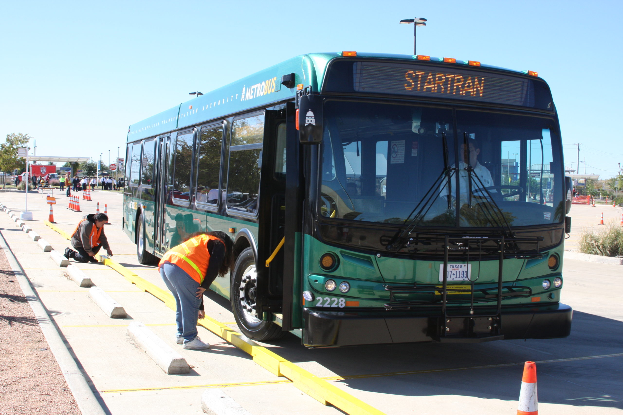
Houston—with a population ranked 4th in the nation by city proper, 5th by immediate metro area and 9th by expanded metro area—is infamous for its wide highways, sprawling cityscape, poor walking infrastructure in many areas, and nearly ubiquitous accommodation of the motor vehicle. Yet Houston has also become a public transit leader by significantly redesigning its bus service from the ground up in 2015 to focus on giving as many people as possible access to frequent, high quality transit, with help from transit consultants Jarrett Walker & Associates.
Houston is recognized as a leader for good reason. The city redrew its former bus network from scratch, allowing METRO (the city’s transit agency) to consolidate redundant routes into more frequent, centralized patterns that served population centers more often.
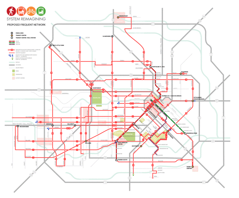
On August 15th, 2015, a network of mostly infrequent bus routes converged downtown, which was not where most bus riders needed to go in the very decentralized metro area. On August 16th, these same buses ran on a brand-new network, a grid of 22 frequent routes that allowed access to multiple spread-out dense activity centers and neighborhoods. It was a transformation that required no new resources (outside of signage and wayfinding changes), just a smarter approach that recognized the city’s changing development patterns. (Read Smart Growth America’s longer 2015 profile of this story, just before the changes went into effect, which details the planning and work that went into it.)
There are a few things worth recognizing when discussing the replicability of Houston’s plan in other cities. Houston’s old network had clear redundancy in its routes. In other cities these routes may not exist, or have been cut in the past, so a comparable result to Houston’s “cost-neutral” solution may require greater investment overall or adding more resources elsewhere. Houston is also anchored by the Red Line, one of the most successful modern light rail projects in the country, and having that service as a network cornerstone bolstered METRO’s ridership on both modes.
While Houston is a popular example of a completely redesigned network, the idea has been successfully replicated at smaller scales.
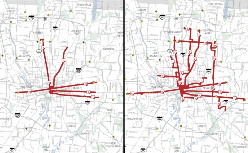
Columbus: Before Columbus redesigned its routes in 2017, for example, their bus map had been largely unchanged since 1974—even though the region had become one of the fastest-growing in the country. COTA (the Central Ohio Transit Authority) didn’t have the fleet size or duplicative routes that Houston’s METRO did, but managed to add seven frequent routes to their previous total of three, including two new crosstown routes that matched the city’s multi-centered development patterns.
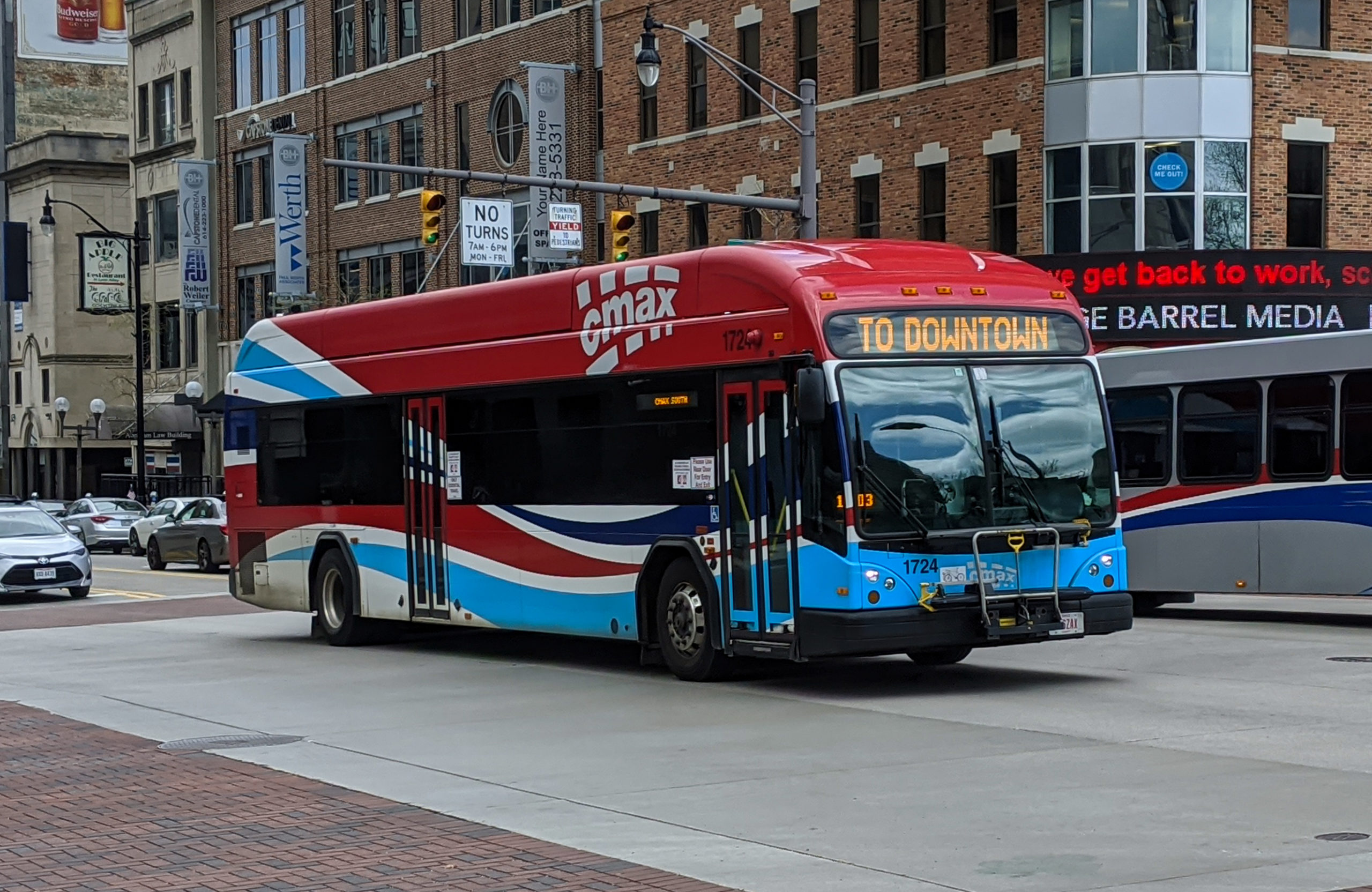
Equity was a major concern during Columbus’ route redesign, leading Columbus to emphasize improving the frequency of their routes on weekends. Columbus also introduced their CMAX rapid bus line in 2018. While not “true” bus rapid transit—lacking dedicated lanes, off-board fare payment, and frequent headways on weekends—it still provides a solid anchor service for COTA’s other routes to feed into.
Despite a nationwide decrease in transit ridership in the 2010s, Houston and Columbus both grew their ridership with their redesigns. Within a year of opening Houston saw a six percent growth in system ridership, and before the pandemic, Columbus’ ridership was up four percent overall since the 2017 redesign. This occurred because both cities updated their transit network to match changes in development patterns, improving transit access in the process.
In Austin, a strong baseline is paying off
Austin’s population has nearly doubled from 2000-2020 and its transportation systems are struggling to keep up, but the region’s major transit agency, Capital Metro, is working its way toward an accessible and intuitive system.
In 2010 Austin launched Capital Metrorail, a 32-mile commuter rail line that failed to draw significant riders, because it runs infrequently and misses much of the city’s density. To address that gap, in 2014, Capital Metro launched MetroRapid, a rapid bus system (similar to Columbus’ CMAX) featuring two lines making limited stops along some of the city’s main north-south corridors, hitting the neighborhoods that Metrorail missed, including the downtown core, south Austin, and the University of Texas. And in 2018, Capital Metro also embarked upon a full bus network redesign, which they dubbed “CapRemap.”
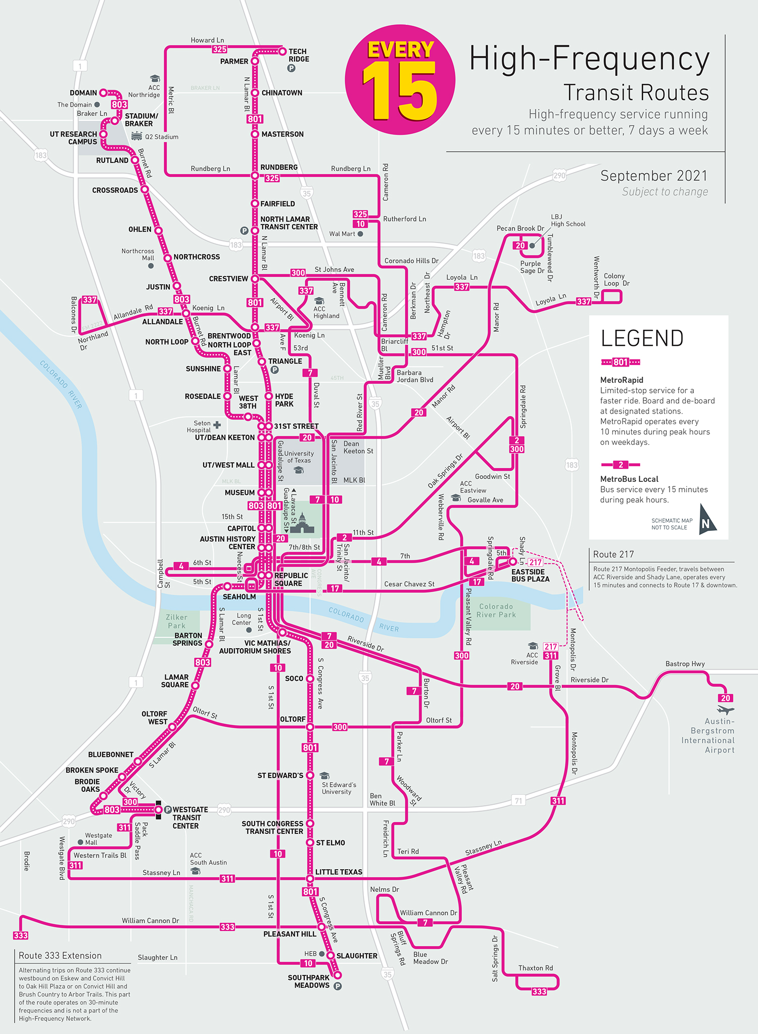
CapRemap followed the principles of Houston and Columbus’ work, achieving similar results. A year after CapRemap’s release, the total bus system’s ridership had increased by about 4 percent and MetroRapid’s increase was about 6 percent—indicating that improving the grid of routes that increase accessibility across the city also strengthens the core of the system. Capital Metro also introduced new standards of mapping and signage that make Austin’s buses easier to use and navigate.
These improvements contributed to the success of a ballot initiative in November 2020 for the agency’s much more ambitious $7 billion ProjectConnect plan (click to see a map.) At the center of that plan are two light rail lines, which largely follow the current MetroRapid routes, paired with the introduction of new MetroRapid upgrades for some of the busiest existing bus routes. ProjectConnect is evidence that a well-planned baseline system will grow public support for more substantial infrastructure through incremental upgrades.
The Twin Cities are focused on serving corridors with the highest driving demand
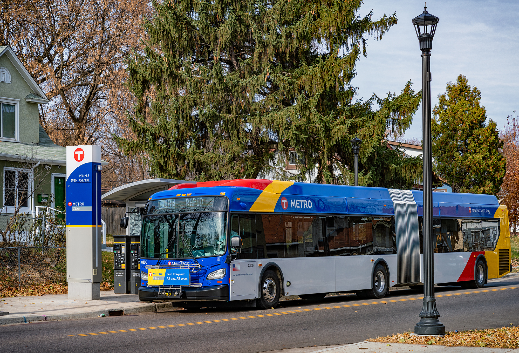
Compared to the prior examples, Minnesota’s Twin Cities are taking a more incremental and perhaps unconventional approach to transit improvement and network strengthening. Like in Houston, many of the region’s main activity centers—like downtown Minneapolis, downtown St. Paul and suburban Bloomington—are connected by well-used local light rail services, which are reinforced by a grid of crosstown bus routes. Sixteen of these bus routes run every 15 minutes or better on corridors that are highly traveled but do not need the level of capacity that rail provides, and the region’s transit agency, Metro Transit, sees this network as a key to improving access throughout the region.

Kick-started in 2010 by the region’s Transit Master Study, Metro Transit has begun upgrading several of its busiest bus lines to what they call rapid arterial routes by “stopping less frequently and allowing passengers to pay before boarding.”
The A Line and C Line are currently operating as “backbone” routes of the bus network, with three more (F, G, and H) prioritized for near-term service frequency upgrades in the agency’s 2021 Network Next plan. This plan, set to be updated every five years, is centered around making data-driven, equitable decisions that improve speed and reliability.
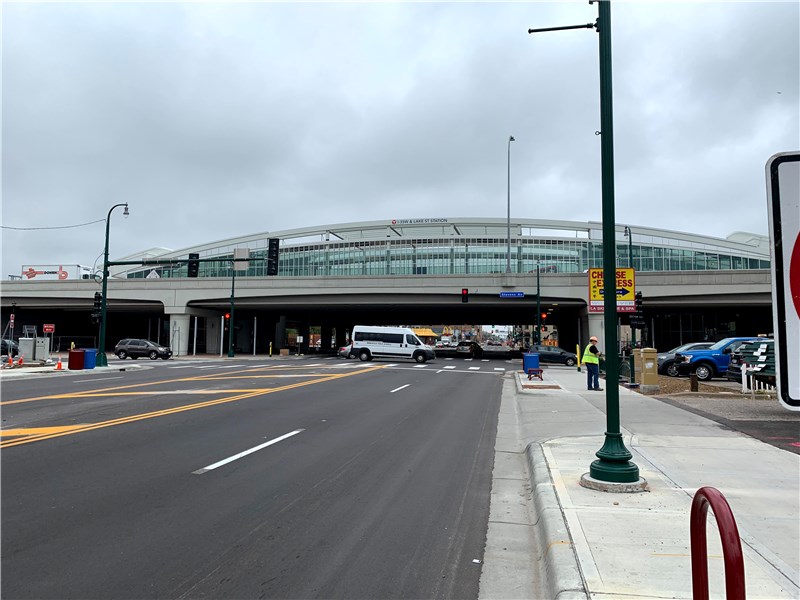
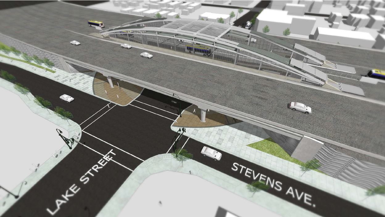
Metro Transit is also working to better integrate local buses into its larger regional bus network, branded with colors, which operates partially on major freeways. The Orange Line, which just opened in December 2021, travels in dedicated high-occupancy toll lanes southward from downtown along Interstate 35W, one of the region’ busiest freeways. Unlike some freeway express routes in other cities, the Orange Line runs in both directions at 15-minute intervals (during weekdays) and serves substantial, accessible modern stations that bridge the gap between the speed of freeway travel and the pedestrian accessibility that serves successful transit. This approach also acknowledges the reality of the region’s multiple centers and serves the places that people are already going by car.

When the COVID-19 pandemic hit, Metro Transit became one of a number of agencies to adjust its service to respond to shifting transit needs and provide better access: by lowering fares, providing near-term service to get students to school in the wake of bus driver shortages, and expanding a program to provide targeted transit passes to specific apartment buildings to better meet the needs of residents and actively reduce car-dependence.
The agency’s strategies stem from three principles, according to Metro Transit arterial bus rapid transit manager Katie Roth, who collaborated with T4A in this case study: 1) to meet the market for transit as it stands today, 2) improve the market for transit for the future, and 3) improve access to transit in communities that have historically suffered disinvestment. “This is how we’re going to emerge from the pandemic as a transit system,” she says.
Following traveler demand and creating a reliable all-day network will boost the resilience of neighborhoods around the region, providing a solid foundation to expand upon with their Network Next plan.
What other communities can learn about improving transit access
Making a real impact on our climate will require providing transit that offers a true alternative to driving. While there is no “one-size-fits-all” answer that works for every city and no US city that has fully solved this puzzle, the agencies profiled here have several things in common: they used data to understand service needs and were willing to rethink their route structure—sometimes dramatically—to provide better access for people most reliant on transit and keep up with changing development patterns, often seeing significant increases in ridership as a result.
Unfortunately, no amount of clever service redesign will make up for resources that simply aren’t there, so increasing transit funding must be part of the picture. And even a significant boost in funding won’t be enough to meaningfully improve transit access for all the people who need it in the more sprawling areas of our metro regions, so putting more people in the path of high quality transit by changing local development practices is a critical step on the path to a lower-emissions transportation system.
The Twin Cities region isn’t the only one that has updated its transit service to respond to evolving needs during the pandemic and beyond. In our final post in this series, we will be profiling agencies that have changed their approach during COVID to shift some focus away from traditional 9-to-5 commuters, make transit more affordable, and rethink what the future of transit should look like to reduce emissions and provide access for those who need it most.
Our three principles

It’s past time to elevate the national conversation about infrastructure.
Learn more about our platformLatest From The Blog

Five for ’25: What to expect on transportation…
Dec 11th, 2024

Meeting the moment after the 2024 elections
Nov 27th, 2024


A pause for TransportationCamp DC
Nov 19th, 2024

I cannot find the zoom link, I registered…
Jan 6th, 2024

A rare look behind the curtain of Transportation…
Jul 28th, 2023

In what Harrison Ford said was his most…
Jul 25th, 2023

Good example, walking to the local taco place…
Jul 24th, 2023