The STB is finally acting to improve freight railroads. Will it be enough?

Freight train
Freight train
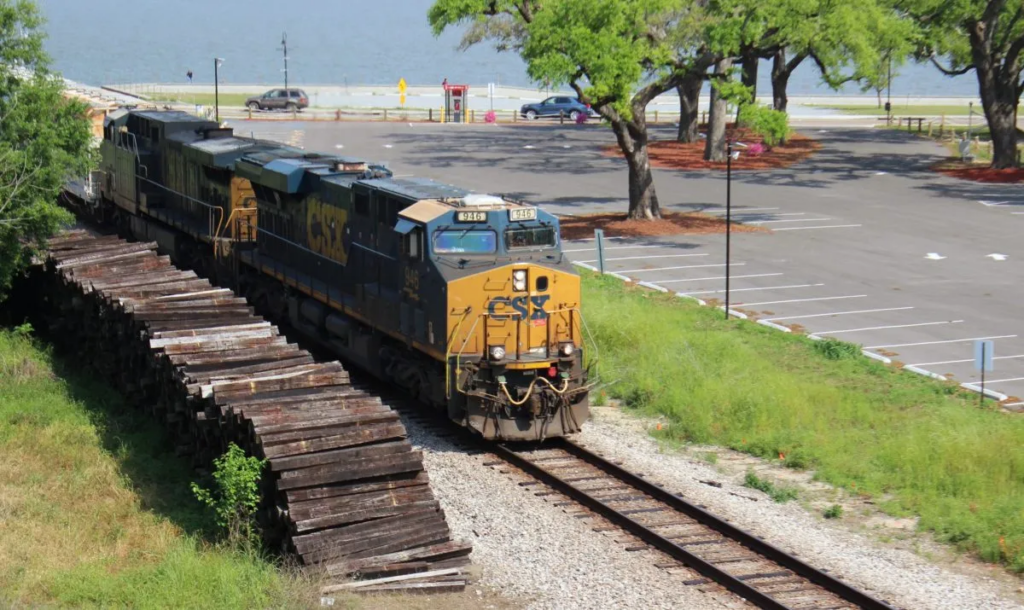
CSX freight train passing through Bay St. Louis, Mississippi Credit: Mississippi Today

After years of looking the other way while deliveries suffered, the Surface Transportation Board finally ruled that freight railroads have to improve their service. Here’s what it could mean for goods and travelers alike.

On Friday, May 6, the Surface Transportation Board (STB) issued a ruling that will require the largest (Class I) freight railroads to improve their anemic service nationwide. These companies are BNSF Railway, Kansas City Southern Railway Company (KCS), CSX Transportation, Inc, Norfolk Southern Railway (NS), Union Pacific Railroad (UP), Canadian National Railway (CN), and Canadian Pacific Railway (CP). 

Under this latest STB ruling, the four Class I carriers with the most significant problems—BNSF, CSX, NS, and UP—will need to submit service recovery plans detailing the specific actions they’ll each take to improve service, including the specific metrics they’ll use to evaluate their progress. Those four will also have to participate in biweekly conference calls with Board staff to ensure they are making significant progress. All seven Class I carriers will be required to submit weekly performance data and monthly employment data to the STB. The STB will receive technical assistance from the Federal Railroad Administration (FRA) in its implementation of this ruling.

Turning the tide

For years, the major freight railroads have trimmed their workforce and overworked remaining staff to report larger profit margins to shareholders, all without regard for service quality. The pandemic has worsened this issue, causing frequent and extended delays in delivery time for key goods and services. For such a critical national system as freight rail, this has been an economic disaster. 

On April 26th and 27th, the four relevant freight railroads testified in front of the STB and admitted their poor service, but they tried to blame national trends and claim they could fix the issues on their own. However, the testimony they gave, such as frequency data that was contradicted by video evidence, was often uninformed and irrelevant, calling into question the validity of their commitments to improve service. The STB likely felt the same, as this aggressive ruling reflects a lack of faith in the freight railroads to address the current crisis.  

Though this ruling is not surprising, it is encouraging. We are pleased to see the STB finally exercising their oversight in a clear and demonstrable way, revealing their intent to monitor and fix this endemic issue. They have always had the authority, but have historically been far too lenient on the freight railroads, which allowed the situation to get to its current point. 

On May 12th, STB chairman Martin Oberman testified in front of the railroad subcommittee of the House Transportation and Infrastructure Committee, where he laid out a vision for a more aggressive STB. He said the STB can and must go further than rulings like this one, and said that “the Board can use its existing authority to mitigate [the problems facing the rail industry] in a meaningful way.” 

We should take these bold statements with a grain of salt. The freight rail industry has not been interested in complying with federal regulations unless forced to do so, so this will likely be a long and drawn out fight despite Chairman Oberman’s commitment to a rapid timeline.

But still, such a bold step from the STB signals a paradigm shift. In the past, the STB has been all but powerless to stop the dominance of the freight railroad companies over the national rail network. But a network so critical to national security should be regulated accordingly, and the STB seems to finally be arriving at the same conclusion.

Impact on passenger rail

This ruling and its implementation might have some benefits for passenger rail, too. For most of the national network, passenger rail service runs on rail owned by the Class I carriers. So if freight railroads continue to be required to improve service, it might improve conditions on the nation’s rail network enough to support improved passenger rail service. In fact, in Chairman Oberman’s testimony, he added that he remains “confident in the Board’s preparedness to meet its responsibility to enforce on-time passenger rail performance.”

To connect people to jobs and services, we need to measure what matters: people

Today we largely decide which transportation projects to build and where to build them based on how much delay vehicles experience, while entirely ignoring everyone not in a car in the first place. By ignoring walking, biking, or taking transit, we’re ignoring the impacts on everyone not using a car, particularly low-income persons, people of color, and older adults.

It’s “Connecting people to jobs and services week” here at Transportation for America. All week we’ll be exploring why improving access should be the goal of the federal transportation program—not vehicle speed.

A century ago, we didn’t have GPS and GIS mapping systems. Google Maps on a handheld computer (i.e. your cell phone) that would allow you to instantly look up directions to anywhere with any mode was still in the realm of science fiction. Given those limitations, when the country started spending billions to build a national network of highways—and a bunch of streets to feed cars onto those highways—the easiest thing to measure was vehicle delay. Free flowing traffic = good; delay = bad. If cars were getting stuck in traffic, it was a sign that we needed to build more or wider roads, or redesign an intersection to improve traffic flow.

This was the most sophisticated proxy for success we could manage for many decades but this myopic focus on vehicle speed also ignored anyone outside a car and it actively undermined other transportation options. People walking or rolling were relegated to sidewalks (if they existed) or banished from the street altogether. Transit was now being mired in traffic and wide, free-flowing roads lured those who could afford a car onto the open road. And if you happened to live in the path of a future freeway—a path often selected because an area was deemed undesirable based on racist redlining policies—your home or business was razed. What remained of formerly walkable and vibrant Black neighborhoods were suddenly cut off from the rest of the community to make room for cars.

None of these people outside of personal vehicles are considered or counted when we use vehicle delay to measure the effectiveness of our entire transportation system. The ability of people walking, rolling, biking, or taking transit to get where they needed to go is sacrificed for people who can afford and operate a car.

This old measure hasn’t scaled very well, either. As more and more Americans began driving, traffic became more common. We hollowed out city centers in a quest to keep cars moving and then give them a place to park. Today, we still hear calls to widen roads to keep traffic moving. The problem, as it’s presented, isn’t that we have too many cars, but not enough road space for all those cars.

With technology available now, we can figure out where people are trying to go, we can measure how easy or hard it is to get there, and we can do this for every mode of transportation, not just cars. We call this measuring access and using it to evaluate how our transportation system is performing and to decide what projects to build next would make for a much more equitable transportation system.

Access to a better future

If you don’t own a car and you rely on walking, biking, or transit, your needs are largely ignored under the current paradigm. If you don’t want to spend $9,000 a year to own and maintain a car, improving your access to jobs and services is secondary to the needs of people driving. If you can’t drive, for whatever reason, you can only hope that there are viable options to get you where you want to go.

Using access as the primary consideration to evaluate projects may show that building and repairing sidewalks in a community would dramatically improve access to jobs and services for more residents than redesigning one intersection for cars (and for the same amount of money). It may show that a new bus line would make it easier for residents in a low-income community to access healthcare. It may show that filling a gap in a bike lane network would improve the ease and safety of reaching the closest grocery store from neighborhoods in a food desert. Or it may show that the length of a bus ride to school could be cut in half with a short connector road. Using access to guide our transportation investments may show these things, but we wouldn’t know because most transportation decisions focus only on the delay of cars alone.

That’s why our third principle for transportation policy is connecting people to jobs and services. Instead of using an outdated proxy that gives us an incomplete and indirect view of whether or not the system is actually working to get people to their destinations, let’s measure the actual thing that proxy was attempting to measure. Congress should direct USDOT and states to determine how well the transportation system connects people to jobs and services, and prioritize projects that will improve those connections.

Measuring access alone won’t erase all the structural issues that disadvantage low-income communities and communities of color, but it will solve one of those issues. By measuring access we can begin to make sure that everyone regardless of income, age, race, or ability can get where they need to go by whatever mode they choose.

Connecting people to jobs and services week: How bad metrics lead to even worse decisions

When the top priority of our transportation investments is moving cars as fast as possible, the end product is streets that are wildly unsafe—as chronicled in depth last week. This focus on vehicle speed and throughput is the result of outdated metrics that utterly fail to produce a transportation system that connects people to what they need every day. 
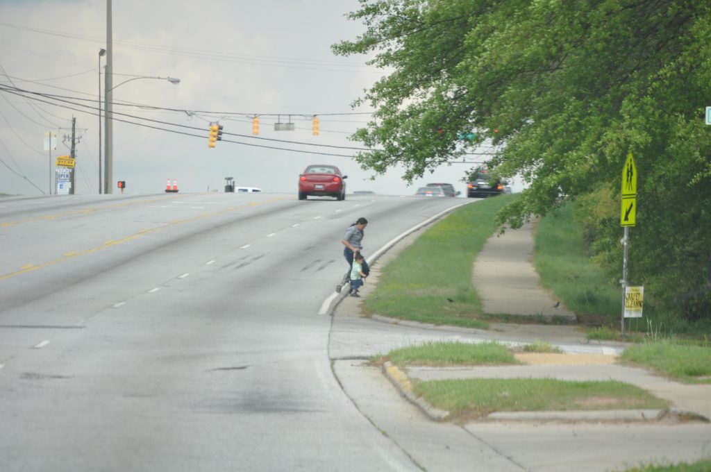
A “successful” street, according to the metrics used by most state DOTs and metro areas. But “moving cars fast” as a goal fails to measure whether or not anyone can get where they are going. We need a better standard for success.

For “connecting to jobs and services” week, which focuses on our last of three principles for transportation investment, we’re re-surfacing portions of a post we wrote in 2016 about how one bad metric for evaluating potential transportation investments leads to expensive road projects that fail to get people where they are going every day.

All this week, we’re going to be unpacking our third principle for transportation investment, which is admittedly the most difficult to explain, especially compared to the first two: (1) prioritizing maintenance, and (2) prioritizing safety over speed. Before we can explain “connecting people to jobs and services,” we need to explain how the current federal transportation system is oriented around all the wrong things.

As we chronicled two weeks ago, if there are any existing priorities for the $40+ billion in annual federal transportation investment, it’s that cars should move fast, at all times, on all types of roads, no matter how many people die as a result. But we do almost nothing to measure whether or not any of this federal spending actually helps people get where they need to go each dayOne reason why is this wonky metric—created by the federal government—that nearly every state and local transportation agency uses to evaluate the success or failure of their transportation network.

Bad measures for success lead agencies to make bad decisions

As they plan projects and decide which transportation projects to fund, state and local transportation agencies exhaustively measure something called “vehicle level-of-service” for almost every single investment. Here’s a story to illustrate:

Wanting to rejuvenate their local economy, a local community cooks up plans to redesign the local street running through downtown that was perhaps even short-sightedly widened or converted to one-way travel in the 1960s or 70s. They want to make it safer and create a better environment for doing business—to make it a place to travel to, not through.

But because the street is also a state highway, they soon hear from the state department of transportation (DOT) that their proposed changes will slow down traffic and fail to meet “level-of-service” requirements. As a result, the project will fail to make the cut of the state’s short list of projects. Worse yet, the community is told that in order to make this street safer and “solve” congestion, they actually need to widen it and smooth out any curves, making it a virtual speedway, undercutting their plans to build a place with more enjoyable places to walk and visit—a framework for creating economic prosperity.

This terrific cartoon from Andy Singer shows how this rationale leads us to obliterate all the good things about our streets and places in pursuit of improving level of service:

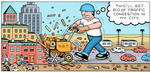
A guy rototills his garden to eliminate weeds

andy singer cartoon rototil congestion city level of service street road design

What is level of service, and how do DOTs come to this conclusion?

Level of service is a system by which road engineers measure how well a road is performing based on the number of cars and the delay that vehicles experience on that roadway. Letters designate each level, from A to F. Just as with our time in school, A is great, and F is terrible.

A, B and C represent free-flowing conditions and F is stop-and-go traffic for vehicles. The score is assessed based on the highest level of congestion on that roadway, even if it only occurs for a few minutes a day. (To be clear, a street that is nearly empty 23.5 hours of the day can get an F if it gets congested during rush hour.) Traditionally, roadway conditions are acceptable if they score a C or higher on non-urban streets and a D or higher on urban streets.
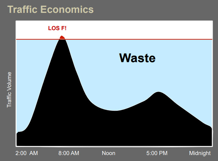
This graphic, created by Jeff Tumlin, the new head of the SFMTA in San Francisco, illustrates how roads can be massively over-engineered to avoid level-of-service “F” with expensive capacity that largely goes wasted during the bulk of the day. Graphic via Strong Towns.

The level-of-service measurement is calculated by first measuring the amount of traffic during the busiest 15 minutes of an evening rush hour. Next, traffic engineers project the amount of traffic on the road in 20 or 30 years to determine if the road has enough capacity to cover the lifespan of the asset. If a road is projected by traffic engineers to lack capacity 20 years in the future—an incredibly fuzzy practice that’s far more art (or more accurately magic) than math—that road still receives a failing LOS grade today, even if the road is adequately suiting capacity needs.

Though there are no formal or federal requirements to do so, most DOTs, metropolitan planning organizations and traffic engineers rely on the level of service (LOS) transportation metric as they plan and design projects, and evaluate which ones will receive funding. I.e., projects that “improve” it get the fast track for funding, and projects that might make it “worse” are shelved or modified.

According to Jason Henderson, professor of geography at San Francisco State University, “Every city I’ve ever come across has some use of [LOS].” Because of the ubiquity of LOS, this largely misunderstood measurement has profound influence on the design of our communities.

This heavy reliance on level of service has dramatically shaped our cities, and it’s why states and metro areas and cities have spent billions to “solve” congestion in a way that has produced dangerous streets, dilapidated downtowns, economic disaster, and long-term maintenance costs that no locality can cover on their own.
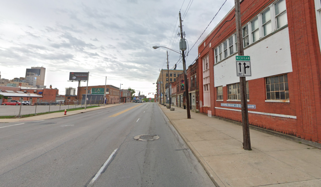
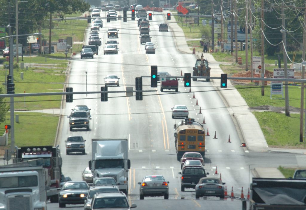
Toledo and many other Rust Belt cities have little to no congestion and many of their in-town streets enjoy level of service “A.” Is that a good measure for success?

As Gary Toth from the Project for Public Spaces brilliantly put it in this piece, transportation professionals, “in search of high LOS rankings, have widened streets, added lanes, removed on-street parking, limited crosswalks, and deployed other inappropriate strategies” all because level of service has been the de facto standard over the last 50 years.

Every great street that you can think of in most places you want to visit on vacation probably “fails” level of service.

Congestion and level of service is “bad” because the street is home to numerous places people want or need to visit, the sidewalks are too wide and filled with pedestrians window shopping, there might be bike lanes to allow people to arrive without a car, and it’s almost certainly chock full, not necessarily of vehicles, but of people.
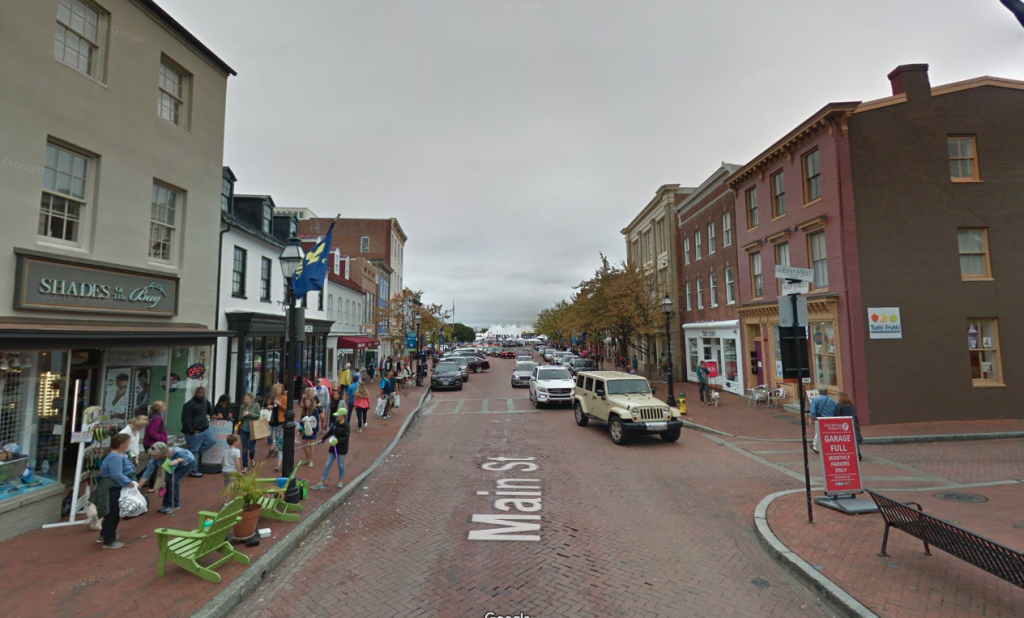
Poor level of service in Annapolis, MD. Tear down those buildings and you could add a couple of lanes in each direction and fix it!

Where did this measure come from?

The 1965 federal Transportation Research Board Highway Capacity Manual introduced this metric and it quickly became accepted as the standard measure of roadway performance. One reason that states adopted level of service so quickly was that it suited our country’s transportation goals in the 1960s of building out a network of interstates and prioritizing automobiles to travel quickly.

But as we explained at length last week, building highways and interstates with speed as the top priority is wildly different from building local and regional streets that create a framework for capturing value and providing for the safe movement of people, whether in a car or not.

Although LOS quickly became the standard, transportation agencies at any level are actually not explicitly required to use it: there are no planning or project design requirements that mandate the use of either LOS or travel modeling. FHWA [in 2016] issued a memo clarifying that level-of-service was never a federal requirement.1 But states persist, partially because the feds have never proposed a better measure of success or a more holistic overarching goal for what our billions are supposed to accomplish.

California was the first to make a notable shift, but more is needed

California set out to change the way they designed their streets and communities by changing the way they measure their performance. In 2013, California legislature passed a law directing the Office of Planning and Research (OPR) to instead measure vehicle-miles traveled (VMT), making it possible for projects aiming to reduce driving to fare well in the evaluation process. In 2013, Governor Jerry Brown signed into law SB 743, eliminating the use of level of service for projects within designated transit priority areas (i.e, areas with decent transit service.)

As Streetsblog LA reported in 2013, because most urban areas fall within the state-defined parameters of a transit priority area, this means that level of service is largely eliminated as a consideration for urban projects. Additionally, SB 743 authorized Governor Brown to develop a new way of measuring traffic impacts of major projects statewide and based the new way on total vehicle miles traveled (VMT) rather than intersection congestion.

Depending on how California implements this, it would change how development and transportation projects are analyzed and scored in traffic impact studies and thus send the state’s billions in transportation dollars toward projects that will help meet the state’s overall goals—rather than projects that will simply keep the cars moving quickly at all costs.

In short, instead of measuring the success of a proposed project by only the limited measure of whether or not traffic might slow for a few minutes per day at rush hour, CalTrans will now measure whether or not a project contributes to other state goals, like reducing greenhouse gas emissions, developing affordable multimodal transportation options for residents, preserving open spaces, or promoting diverse land uses and infill development. It is expected that this change will make it easier to build transit projects, as well as bicycle and pedestrian-friendly infrastructure—instead of encouraging more development that works against California’s own environmental and other goals.

$40+ billion is spent each year with no clear measures for success other than “move cars fast”

We need better priorities for federal transportation investment than just “move cars fast, all the time.” A fundamental principle has to be that the people who use our transportation system should be able to get where they are going. That’s where we are going with our third principle, which we’ll be unpacking in another post: “Connect people to jobs and services.” This metric would be a far better measure of success than anything on the books today, and some places are already starting to implement it.
California officially dumped the outdated “level of service” metric — your state should too

California made a small but crucial change to how they measure the performance of their streets in 2013, shifting away from a narrow focus on moving as many cars as fast as possible and taking a more holistic view and measuring a street’s performance against a broader list of other important goals. So what is this outdated “level of service” measure and how can other states follow California’s lead?

Wanting to rejuvenate their local economy, a community cooks up plans to redesign the local street running through downtown that was perhaps even short-sightedly widened or converted to one way travel in the 1960’s or 70’s. But as the street is also a state highway, they soon hear from the state department of transportation (DOT) that their proposed changes will slow down traffic and fail to meet “level of service” requirements and won’t make the cut of the state’s short list of projects. Worse yet, the community is told that in order to make a street safer, they actually need to widen it and smooth out any curves, making it a virtual speedway, undercutting their plans to build a place with more enjoyable places to walk and visit — a framework for creating economic prosperity. Heard this story before?

What is level of service, and how do DOTs come to this conclusion?

Though there are no formal or federal requirements to do so, most DOTs, metropolitan planning organizations and traffic engineers rely on a metric known as level of service (LOS). According to Jason Henderson, professor of geography at San Francisco State University, “Every city I’ve ever come across has some use of [LOS].” Because of the ubiquity of LOS, this largely misunderstood measurement has profound influence on the design of our communities.

Level of service is a system by which road engineers measure how well a road is performing based on the number of cars and the delay that vehicles experience on that roadway. Letters designate each level, from A to F. A, B and C represent free-flowing conditions and F is stop-and-go traffic. The score is assessed based on the highest level of congestion on that roadway, even if it only occurs a few minutes a day. Traditionally, roadway conditions are acceptable if they score a C or higher on non-urban streets and a D or higher on urban streets.

The LOS measurement is calculated by first measuring the amount of traffic during the busiest 15 minutes of an evening rush hour. Next, traffic engineers project the amount of traffic on the road in 20 or 30 years to determine if the road has enough capacity to cover the lifespan of the asset. If a road is projected by traffic engineers to lack capacity 20 years in the future — an incredibly fuzzy practice that’s far more art (or magic?) than math — that road still receives a failing LOS grade today, even if the road is adequately suiting capacity needs.

This heavy reliance on LOS has dramatically shaped our cities. As Gary Toth from the Project for Public Spaces brilliantly put it in this piece, transportation professionals, “in search of high LOS rankings, have widened streets, added lanes, removed on-street parking, limited crosswalks, and deployed other inappropriate strategies” all because LOS has been the de facto standard over the last 50 years. This terrific cartoon from Andy Singer that Toth includes shows the rationale in practice:

A guy rototills his garden to eliminate weeds

andy singer cartoon rototil congestion city level of service street road design

Where did this measure come from?

The 1965 federal Transportation Research Board Highway Capacity Manual introduced the LOS metric and it quickly became accepted as the standard measure of roadway performance. One reason that states adopted the LOS so quickly was that it suited our country’s transportation goals in the 1960’s of building out a network of interstates and prioritizing automobiles to travel quickly.

Although LOS quickly became the standard, transportation agencies at any level are not explicitly required to use it: there are no planning or project design requirements that mandate the use of either LOS or travel modeling. FHWA recently issued a memo clarifying that level-of-service was never a federal requirement. Read more about that (and some other important changes) in this recent story:

If we are going to change the way our streets and communities are designed, we will need to change the way we measure their performance. And that’s exactly what California has set out to do. In 2013, California legislature passed a law that began the shift, directing the Office of Planning and Research (OPR) to use an alternative of measuring vehicle-miles traveled (VMT).

In 2013, Governor Jerry Brown signed into law SB 743, eliminating the use of LOS for projects within designated transit priority areas (TPAs). As Streetsblog LA reported in 2013, because most urban areas fall within the state-defined parameters of a TPA, this means that LOS is largely eliminated for urban projects. Additionally, SB 743 authorized Governor Brown to develop a new way of measuring traffic impacts of major projects statewide and based the new way on total vehicle miles traveled (VMT) rather than intersection congestion. This will change how development projects are analyzed and scored in traffic impact studies and thus the type of projects that match up with the state’s goals for development.

In short, instead of measuring the success of a project by only the limited measure of whether or not it will make it less convenient to drive, CalTrans will now measure whether or not a project contributes to other state goals, like reducing greenhouse gas emissions, developing affordable multimodal transportation options for residents, preserving open spaces, and promoting diverse land uses and infill development. It is expected that this change will make it easier to build transit projects, as well as bicycle and pedestrian-friendly infrastructure — instead of encouraging more development that works against California’s own environmental and other goals.

How can other states replicate this move?

Great question.

This change in California is just one of the many smart policy changes that we’ll be covering in detail in Sacramento this November at Capital Ideas II, our one-of-a kind conference on state transportation policy. We’ll have experts on hand from California who will be discussing their legislative and policy shift away from level of service. Expect to hear more about that as we finalize the agenda in the coming weeks and share it here with you.

Learn More & Register

Capital Ideas II


More on the engineering metric that has an outsize impact on the design of our communities

California changed how the state measures the performance of their streets in 2013, shifting away from a narrow focus on moving as many cars as fast as possible — level of service (LOS) — and taking a more holistic view and measuring their performance against a broader list of other state goals that were often in conflict with LOS. But what is LOS? How does it impact how communities can design their streets?

In this second post of a longer series on level of service (LOS) only for T4America members, we walk through this metric in more detail and explain how it often works against a state’s, metro area’s or city’s other stated goals. Read the first post here.

Introduction

You may be familiar with this story: a community has plans to rejuvenate the economy by redesigning the local street (yet also state highway) running through its downtown, only to be told by the state department of transportation (DOT) that their proposed changes will slow down traffic and doesn’t rate high enough on their metrics to make it onto the short list of projects. Worse yet, the community is told that in order to make a street safer, they actually need to widen it and smooth out any curves, making it a virtual speedway, which would undercut the economic development opportunities.[1]

How do DOTs come to this conclusion that the proposed changes or new development would cause the roadway not to perform well? Most DOTs, metropolitan planning organizations and traffic engineers rely on a metric known as level of service (LOS). According to Jason Henderson, professor of geography at San Francisco State University, “Every city I’ve ever come across has some use of [LOS].”[2] Because of the ubiquity of LOS, this largely misunderstood measurement has profound influence on the design of our communities.

What is level of service?

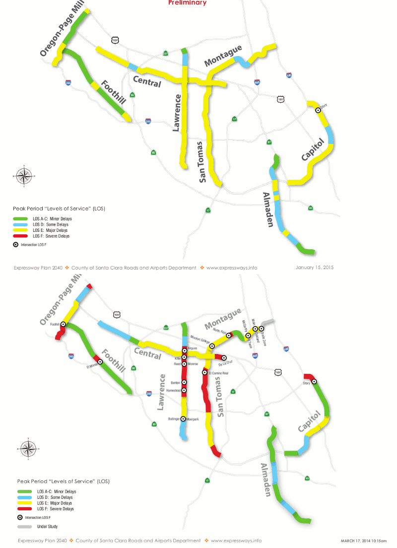
Level of service is a system by which road engineers measure road performance on a graded scale of A through F. LOS measures how well a road is performing based on the number of cars and the delay automobiles experience on that roadway. Letters designate each level, from A to F, with LOS A, B and C representing free flowing conditions, while LOS F is stop-and-go traffic.[3] The score is assessed based on the highest level of congestion on that roadway, even if it only occurs a few minutes a day. Traditionally, roadway conditions are acceptable if they score a C or higher on non-urban streets and a D or higher on urban streets.[4]

Example of level of service graphic[5]

Santa Clara County Expressway Level of Service Map

The LOS measurement is calculated by first measuring the amount of traffic during the busiest 15 minutes of an evening rush hour. Then traffic engineers project the amount of traffic on the road in 20 or 30 years using the result of that measurement to determine if the road has enough capacity to cover the lifespan of that asset.[6]

One surprising aspect of the usage of LOS that many people don’t realize is how LOS is not just about how a road functions today. If a road is projected by traffic engineers to lack capacity 20 years in the future — an incredibly fuzzy practice that’s more art than math — that road still receives a failing LOS grade today, even if the road is adequately suiting capacity needs.[7]

The history of LOS

The 1965 federal Transportation Research Board Highway Capacity Manual introduced the LOS metric and it quickly became accepted as the standard measure of roadway performance.[8] One reason that states adopted the LOS so quickly was that it suited the country’s transportation goals in the 1960’s of building out a network of interstates and prioritizing automobiles to travel.[9]

Although LOS became the standard, transportation agencies at any level are not explicitly required to use it: there are no planning or project design requirements that mandate the use of either LOS or travel modelling. Planning manuals from both the the Association of American State Highway and Transportation Officials (AASHTO) and the Federal Highway Administration “clearly state that these are guidelines to be applied with judgment — not mandate(s)”[10]

It is important to point out that although LOS was initially meant exclusively for highways and cities aren’t required to abide LOS as a course of law, over the years the measure has hardened into convention for all roads. The adoption of this convention means that LOS has routinely been used for the design of city streets.[11] Eric Jaffe of Atlantic Cities in 2011 noted that “By the time cities recognized the need for balanced transportation systems, LOS was entrenched in the street engineering canon.”[12]

What’s next in the series on LOS?

In our forthcoming third post in this series, we will explain in more practical detail how LOS has damaged communities, organizations, and advocates promoting smart-growth. As Gary Toth from the Project for Public Spaces brilliantly put it, transportation professionals, “in search of high LOS rankings have widened streets, added lanes, removed on-street parking, limited crosswalks, and deployed other (anti-smart growth) strategies” all because LOS has been the de facto standard over the last 50 years.[13]

If we are going to change the way our streets and communities are designed, we will need to change the way we measure their performance.

Citations