
Safety over speed week: Slip lanes would never exist if we prioritized safety over speed

A specific design feature on our roadways is the quintessential embodiment of what happens when speed is the #1 priority and safety becomes secondary. Slip lanes, those short turning lanes at intersections that allow vehicles to turn right without slowing down, are incredibly dangerous for people walking. Yet states & cities keep building them. Why?
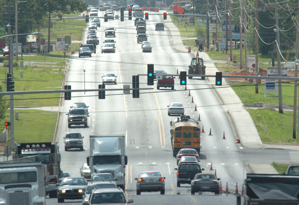
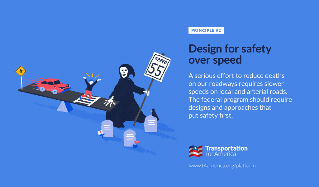
It’s “safety over speed” week here at T4America, where we are spending the week unpacking our second of three principles for transportation investment. Read more about those principles and if you’re new to T4America, you can sign up for email here.

Any traffic engineer or transportation official would surely tell you that safety, if not the most important consideration, is truly a core priority. But embedded deeply in our federal transportation program is another guiding principle that stands in direct opposition to safety:  “Cars need to always move fast and never slow down.” Whatever the stated priorities are, this hidden prerequisite makes every other goal a nearly impossible task—especially safety. 

Slip lanes on roads and streets are emblematic of what it looks like in practice to sacrifice safety on the altar of speed, where this underlying goal of “keep cars moving fast at all times” runs counter to the goal of “keep everyone safe while moving from A to B”—even if you say that safety is important. If we truly prioritize safety, as T4America is suggesting in our second principle, we would never build a slip lane on a local street again. 1

What are slip lanes and why do they exist?

It’s important to remember that slip lanes were created to solve one specific set of problems: vehicle speed and delay. 

They were borne of the simple realization by traffic engineers that cars turning right—even on a green light—can produce dreaded congestion because slowing down to a safe turning speed can delay traffic traveling straight. So to solve this one problem, they started adding lanes that allow traffic to make right turns without being required to slow or come to a stop, often accompanied with an additional lane on the approach or the exit. Whether you live in a rural, urban or suburban area, this feature isn’t hard to find: they’re a regular feature in most environments that were designed and built with federal money and guidance over the last 50 years. 

Safety was always at best a secondary consideration, though it really wasn’t considered much at all for decades as traffic engineers started adding slip lanes to road projects all over the country.

Slip lanes are dangerous because they prioritize vehicle speed over the safety of everyone who needs to use the road

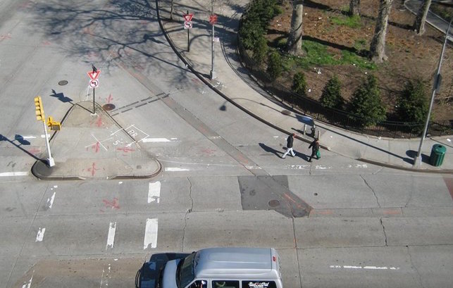
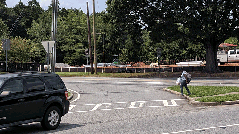
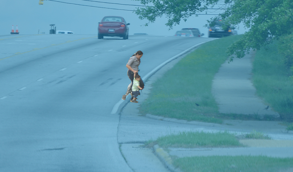
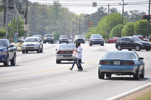
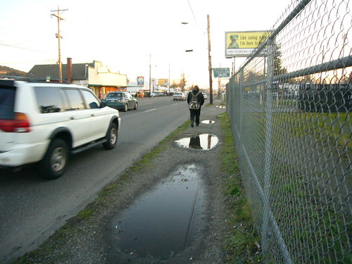
Slip lanes increase the distance that people have to cover to cross a street, put people into spots that are often the hardest for drivers to see, and encourage drivers not to slow down when approaching an intersection and a crosswalk—the precise moment they should be the most careful. This slip lane I saw in N. Fulton County, Georgia earlier this summer is a pretty typical design. 

Traveling east on N. Hembree Road (with a speed limit of 40 mph!), if a driver is planning to turn right here and sees the green light ahead, all the design cues are directing the driver to blaze through the right turn onto Alpharetta Highway without slowing down. That driver could be hitting maximum speed right as they reach the crosswalk across the slip lane—exactly the spot where engineers have said that a pedestrian should “safely” cross this street.

I saw a woman crossing here and I was astonished to see that in the time that it took her to take just three steps from the middle of the street towards safety, a minivan goes from entirely out of the frame to just 10 feet away from her.

Because slip lanes were borne of the sole focus on avoiding vehicle delay, all efforts to make them “safer” will be limited. Safety is not why they exist. Even the Federal Highway Administration (FHWA) knows they are inherently unsafe—it’s astonishing to read their guidance for making them, in their words, “less problematic”:

Intersections should be designed to accommodate safe pedestrian crossings using tight curb radii, shorter crossing distances, and other tools as described in this document. While right-turn slip lanes are generally a negative facility from the pedestrian perspective due to the emphasis on easy and fast vehicle travel, they can be designed to be less problematic.

How are slip lanes emblematic of safety losing out to the ultimate priority of speed?

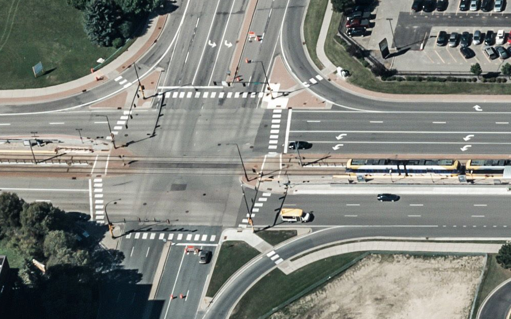
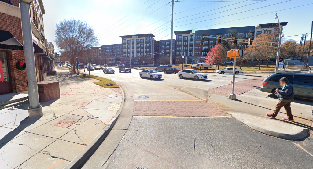
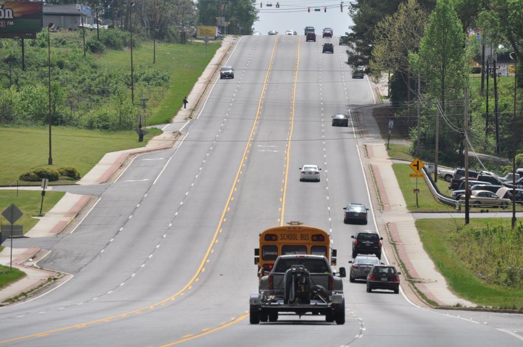
Here’s an intersection in Minneapolis with slip lanes on all four sides. These don’t exist primarily to make anyone safe—safety is an add-on consideration to the primary desire to keep cars moving as fast as possible through this intersection. Those crosswalks and pedestrian “islands” that you see aren’t designed to get anyone across this street in the safest way possible, they are a half-hearted attempt to make the best of a road designed explicitly to keep cars moving quickly above all else. 

Making the experience for people walking on a “negative facility…to be less problematic,” is a pretty interesting choice of words to describe a deadly design feature at a time when pedestrian fatalities are hitting numbers not seen since 1990. But we keep building them because moving vehicles quickly and without delay is the outcome we care about above all others.

What prioritizing safety over speed would look like

As we say in our second principle, local and arterial roads must be designed to put safety first. Protecting the safety of all people who use the street must be a priority reflected in the decisions we make about how to fund, design, operate, maintain, and measure the success of our roads. The next surface transportation law must make safety a priority and start to undo the damage wrought by decades of federal design guidelines and billions in federal transportation dollars.

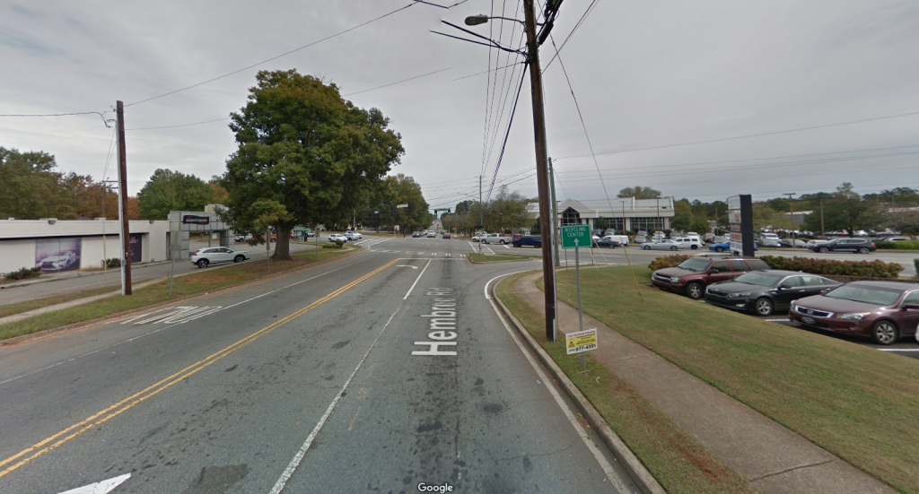
So what would this look like in practice? This small change in Arlington, Virginia is a great example. 

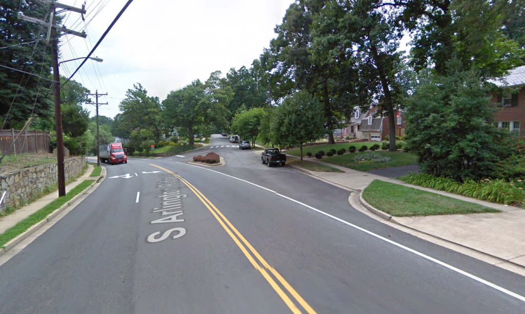
This is a minor collector road that runs largely through a residential neighborhood—not too far from the future home of Amazon’s second HQ. This slip lane made it possible for drivers to whiz into the neighborhood street without so much as a tap on the brakes. Look down the street and what do you see right after cars have sped through the gentle right turn? A crosswalk. That’s what it looked like back in 2009, but here’s what it looks like today:

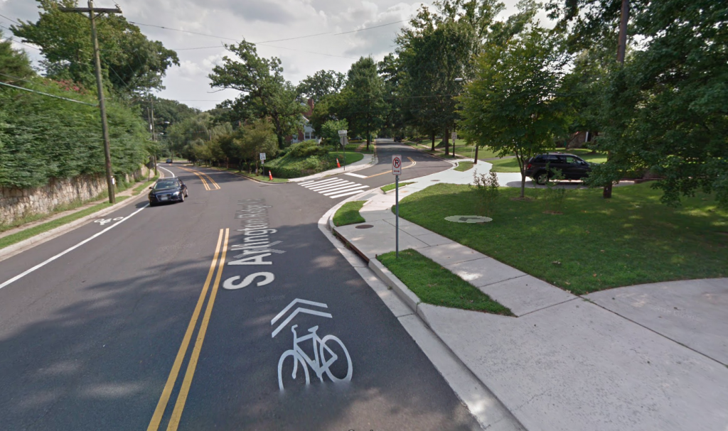
The lanes were narrowed, the slip lane was eliminated, the right turn was converted into a sharper turn that requires drivers to slow down before turning, and the crosswalk was moved to the safest and shortest point of the intersection where pedestrians will be the most visible. 2

It’s very possible that because cars now have to slow down to turn right, that traffic occasionally slows down on the main road. There could even be a slight back up if a few people are turning right and have to yield to someone crossing the street. But this change is exactly what it looks like in practice to prioritize safety over vehicle speed or delay. 

While this small change is certainly one worth celebrating, this isn’t the standard practice of state DOTs that control the lion’s share of federal transportation funds, and speed remains their number one priority—even if they have a stated commitment to safety. This project was the result of a local county making decisions on their own and with their own funds. Most states will not change their practices unless Congress gives a guiding directive that the lives of the 40,000 people who die as a result of traffic fatalities each year are more important than a few seconds of delay.


Access to safe, convenient transportation is a fundamental right. Today, most Americans are denied this right because their roads—not just their highways—are designed to move vehicles at the highest speeds possible, and roads are not designed for people walking, biking, or taking transit as a priority. Safety may be important, but it’s never the top priority when designing these streets.

Until we come to grips with the fact that moving cars fast at all times of day without delay is a goal that can’t always be squared with our other priorities—especially safety—and until we can admit that perhaps everyone is not going to be able to go fast all the time, we’ll continue building unnecessarily large and expensive roads where thousands of people are killed each year.

No more slip lanes. Because safety should be a primary goal of our transportation investments.

Competition: Which street is the most dangerously-designed?

This week, we’ll be taking a deep dive on our second principle for transportation policy: design for safety over speed. Throughout the week, send photos of streets in your area that are designed for speeds far higher than the posted speed limit or where the speed limit is way too high for the context. On Friday (Nov. 8), you’ll have a chance to vote for the worst offender.

At slow speeds, cars can mix safely with other road users. High-speed interstates remove conflicts to keep people safe. But when people and high-speed traffic mix, that’s a recipe for disaster.

There’s a difference between the speed limit posted on a road and the speed the road has been designed for. People will drive at the speed they feel comfortable, regardless of the speed limit. Wide, straight lanes with open skies, long blocks, and few traffic signals or stop signs tell drivers it’s okay to go fast. Conversely, narrower lanes, more frequent crossings, and street trees can encourage slower speeds that are more appropriate for developed areas.

Off the interstates, in areas with shops & restaurants, offices, schools, and homes, we should be designing for slower speeds—speeds that keep people walking, biking, or taking transit safe and comfortable. Too often these very streets are designed to encourage high-speed thru traffic and then we wonder why our streets are so dangerous to people walking and biking.

Send us photos of dangerous streets in your area! Email us at jenna.fortunati@t4america.org or tweet your photo(s) to @t4america and tell us a little bit about it. On Friday, we’ll poll our followers to identify the most egregious example of a street that prioritizes speed of people’s safety.

Examples of unsafe streets abound, and it’s not just suburban arterials. Take for example, Georgia Ave NW through the heart of Washington, DC. The posted speed limit is 30mph, but this four-lane, two-way road is arrow straight and drivers rarely travel at or below 30.

Within a few hundred yards of this photo there are laundromats and pharmacies, numerous bars and restaurants, homes for thousands of people, an elementary school, and a church. There’s also a metro stop and a dozen different bus stops—people walking are everywhere. Yet the design of this street clearly prioritizes the speed of car traffic over the safety of everyone else.

We want you to send us photos of streets where cars routinely drive above the speed limit (or where the posted speed limit is way too high) because the street isn’t designed to prioritize safety, or not designed appropriately for its busy context. Snap a photo this week and send them to us with a short description via twitter or email. On Friday, we’ll hold a poll on our Twitter account where you can vote for the worst offenders.

Safety over speed week: There’s one thing that almost every fatal car crash has in common

We face an epidemic of people struck and killed while walking and biking because our local streets—not just highways—are designed to move vehicles at the highest speeds possible rather than prioritizing the safety of everyone. It’s high time to stop sacrificing safety on the altar of speed with the tens of billions that the federal government spends every year. Here’s how Congress could make that happen.

It’s “safety over speed” week here at T4America, and we are spending the week unpacking our second of three principles for transportation investment. Read more about those principles and if you’re new to T4America, you can sign up for email here. Follow along on @T4America this week and check back here on the blog for more related content all week long.

Let’s start with a number: 49,340. 

That’s how many people were struck and killed by cars while walking on streets all across the United States between 2008 and 2017. Almost 50,000 preventable deaths. 

And yet, by and large, we call these crashes “accidents.” We still believe that these 50,000 deaths, and the deaths of almost 32,000 people every year killed inside of vehicles, are either just the cost of doing business for our transportation system, or were the product of bad behavior: distracted drivers, fatigued drivers, drunk drivers, or drivers not wearing seat belts. 

There’s no doubt that distracted driving increases crash risk and should be punished. But distracted driving can’t explain all of these deaths. There’s one thing that almost every crash has in common, though: high vehicle speed.

When crashes occur at higher speeds, they are more likely to be fatal, especially when they involve a person biking or walking.

In 2017—the year in which pedestrian and cyclist fatalities first reached the highest level since 1990—the NTSB issued a landmark study about how speed is the #1 culprit in traffic fatalities, finding that scores of crashes would not have been fatal at lower speeds. 

It’s easy to ignore something that you don’t understand, and most policymakers don’t understand when and how high speed roads can be safe—and when they aren’t. 

When are high-speed roads safe, and when are they deadly?

The only way to make a high speed roads safe is by separating opposing traffic; removing conflict points, like driveways and cross streets; and separating or removing cyclists and pedestrians. Of course, this is something we frequently do: it’s called a limited-access highway. 

But we’ve tried to design for similar high speeds on our arterial roadways in existing communities while retaining all the points of conflict that make those speeds deadly. Think of any suburban road lined with retail, offices, schools, and homes. Those streets—with multiple destinations along them—are designed like highways.3


Graphic from Strong Towns

Our sister organization, the National Complete Streets Coalition, explains that most cyclist and pedestrian fatalities occur on these 35-50 mph arterial roadways in our urban and suburban areas—roads designed for high speed but with all the conflict points of the slower speed streets, like slip lanes or numerous curb cuts for entrances and exits across a sidewalk. 

Reducing speed is the best solution

If we want these roads to be safe, they either need to become limited-access highways (unlikely, expensive and damaging for the local context) or they need to be designed for lower speeds with lower speed limits.

And we know exactly what speed these roads need to be designed for: 35 miles per hour, or less in many cases. But 35 should be the ceiling for these types of roads, not the floor, when it comes to design speed.

We are pursuing higher speed roadways because we have placed jobs and services far away from the homes of the people who need them. We make up for the inconvenient location of everyday necessities with higher speeds in hopes of shorter travel time, but it never works out that way. Instead, we get a lot of traffic congestion as everyone floods onto the same roads, seeking the same far-away, disconnected destinations. Even in free- flowing traffic, people save seconds or, rarely, a minute or two. And for that, we sacrifice thousands of innocent lives each year. More often than not, those killed are children, the elderly or those with lower incomes.

We need to better measure how speed contributes

Currently we only call a crash “speed related” when someone was driving over the speed limit. We don’t track whether the speed limit was inappropriately high, or if the speed  of the car played a factor in the crash or fatality even if the speed was under the posted limit. In fact, numerous local governments across the country are in arguments with states on who has the authority to lower speed limits. 

It’s time to determine and report when speed was a cause of a crash. It’s time to give local governments the authority to lower speeds to make a street safe and appropriate for its surroundings. And engineers should design roadways in support of slower, safer speeds. 

Congress can make protecting the safety of all people who use the street a priority by reflecting this in the decisions they make about how to fund, design, operate, maintain, and measure the success of our roads. The federal program should require designs and approaches that put safety—for everyone—first. 

Many of the most dangerous states for people walking are planning for more people to die

13 Americans per day were struck and killed while walking from 2008-2017, according to a report released today by our colleagues at the National Complete Streets Coalition. Dangerous by Design 2019 also shows how some of the most dangerous states are, astonishingly, committed to making the problem even worse.

View the rankings and the full report

Over the last decade (2008 through 2017, the most recent year with data available), drivers struck and killed 49,340 people walking in communities large and small across the U.S. To put that into perspective, it’s the equivalent of a jumbo jet full of people crashing—with no survivors—every month. During a period when fatalities for people inside vehicles went down 6 percent, pedestrian fatalities increased by 35 percent. Since the last version of Dangerous by Design was released two years ago, the problem has only gotten worse: 4 out of 5 states and major metro areas have become more dangerous for people walking.

How are states planning to tackle this problem?

More than a third of all states aren’t planning to do anything at all. 18 states—including 10 of the 20 most dangerous for people walking—planned to actually increase the number of people killed while walking or biking from 2017 to 2018.

New requirements from the Federal Highway Administration require state departments of transportation to set performance targets for traffic fatalities and serious injuries and then monitor their progress over time. Back in 2017, states had to update their safety goals for 2018, which included setting target numbers for deaths and serious injuries among people walking, biking, or using other non-motorized forms of travel.

Did states respond by setting ambitious targets and creating accompanying plans for how they’d spend their share of billions in federal transportation dollars to make their streets safer for everyone? Unfortunately, a closer look at these targets reveals just how low the bar is for safety in many states.

18 states established targets for non-motorized deaths and injuries that are higher than the number of people killed or injured in the most recent year of data reported. With billions in 2018 federal transportation dollars available to them to devote to improving safety, more than a third of all states committed to…doing what they did last year—or worse. 10 of these 18 states are among the top 20 most deadly according to Dangerous by Design 2019.

The only “acceptable” number of deaths on our roadways is zero. We can and must raise the bar by requiring states to set safety targets that reduce rather than increase the number of people killed or seriously injured while walking or biking on our streets, ultimately working toward eliminating all traffic-related deaths and serious injuries. However, to make this vision a reality, we need strong federal policy with binding enforceable requirements that hold states to higher safety standards. Dangerous by Design 2019 helps make this case.

For more information on epidemic of people struck and killed while walking and to see the full rankings of the top 20 most dangerous metro areas and states, view the full Dangerous by Design report.

This content, adapted from Dangerous by Design 2019, was co-authored and edited by T4America staff.

Introducing “Dangerous by Design 2016”

Crossposted from Smart Growth America and the National Complete Streets Coalition.

Dangerous by Design 2016, released today by our colleagues at Smart Growth America and the National Complete Streets Coalition, takes a closer look at the alarming epidemic of pedestrian deaths, which are on the rise after years of declining.

Share this on Twitter Share this on Facebook

Between 2005 and 2014, a total of 46,149 people were struck and killed by cars while walking. That averages out to about 13 people per day.

Each one of those people was a child, parent, friend, classmate, or neighbor. And these tragedies occurred across the country — in small towns and big cities, in communities on the coast and in the heartland.

The fourth edition of this report being released today again ranks the most dangerous places for people walking by a “Pedestrian Danger Index,” or PDI. It also explores who is most at risk of being struck and killed by a car while walking, including data that looks at pedestrians by age, race, ethnicity, and income.

Explore the online feature to see the full rankings of the 104 largest metro areas in the country and all 50 states, as well as interactive maps of where fatal collisions occurred.

View the data and maps


Join us for the kickoff

Interested in learning more about Dangerous by Design, and what states and metro areas are doing to combat this epidemic? The report authors and other special guests will be talking about this new research during a kickoff webinar today (Tuesday) at 1 pm EST. You are invited.

REGISTER


Register for the event to to learn more about the findings and to hear from the report’s authors, national transportation policy experts, and local advocates about how we can make streets safer by design.

Will Elaine Chao address pedestrian safety?

A confirmation hearing for Elaine Chao, Trump’s nominee for transportation secretary, is scheduled to take place this week, on Wednesday, January 11th on Capitol Hill. We want to make sure pedestrian safety is on her mind.

Tell the Senate Commerce Committee to ask Chao how she plans to address pedestrian safety.

As always, we welcome your reactions, questions, and ideas. Share them on Twitter at the hashtag #DangerousByDesign.

Help show just how dangerous our streets can be for people walking

This fall, our colleagues at the National Complete Streets Coalition will release Dangerous by Design 2016, a report that will again rank the nation’s most dangerous places to walk using the Pedestrian Danger Index. This year’s report will dive deep into how income, race, and place play an outsized role in how likely people are to be killed while walking. And they’re looking for your help when it comes to illustrating just how bad it can be out there.

For too many people, a walk is a deadly risk. Poorly designed streets have led to an epidemic of pedestrian fatalities, especially among people of color and in our nation’s poorest neighborhoods. More than likely, one of these dangerous streets or intersections is near you or is one you have to use every day. When T4America last released a version of this report back in 2011, we had powerful photos submitted from all over the country.

Help illustrate the hazards you face everyday by expanding upon those photos previously submitted. Send in photos of streets in your neighborhood that are “dangerous by design.” Streets like these:

Metro ATL Pedestrians06Metro ATL Pedestrians41Walking in the ditch

Poorly designed streets like these above — often built or designed with federal dollars or guidelines — endanger pedestrians, cyclists and drivers alike. And as this latest edition of Dangerous by Design will expand upon, people of color and census tracts with below average income are disproportionately represented.

Here’s how you can help:

  • Send in photos via email to photos@completestreets.org.
  • High resolution photos are preferred for maximum quality.
  • Please indicate how photos are to be credited if used online or in the report.
  • Provide information about the photo. Where was the photo taken? Is this a street that you have to use regularly?

We want to see the missing crosswalks, missing curb ramps, and the long and dangerous treks along busy highways. We want to see every way that our current road designs have failed to provide for the safety and convenience of everyone that needs to use them. Help show just how difficult and dangerous we’ve made walking for so many people. The NCSC folks are preparing the report now, so pass them along soon!

USDOT proposes to remove restrictive design guidelines that make safer streets more difficult to build

The Federal Highway Administration (FHWA) took an encouraging and surprising step, proposing to ease federally-mandated design standards on many roads, making it dramatically easier for cities and communities of all sizes to design and build complete streets that are safer for everyone.

This proposal is open for comment, and FHWA is waiting to hear from the public.

FHWA design guidelines promoSend a letter of support to FHWA

These outdated federal guidelines get in the way of better street design, but FHWA is proposing to scrap many of them. This is indeed great news, but for these changes to go ahead, FHWA needs to hear that they have strong support for the proposed changes.

Join us and generate a letter to FHWA today. We’ll be delivering your letters in person to FHWA all at once before the December 7th deadline.

Currently, FHWA has a long list of design criteria that local communities and states must adhere to when building or reconstructing certain roads, unless they choose to go through an arduous process of requesting an exception to do things like line a downtown street with street trees, reduce the width of lanes to add a bike lane, or curve a street slightly to slow traffic and make it safer for people in cars and on foot.

In this new proposed rule, FHWA decided after a thorough review to scrap 11 of 13 current design criteria for certain roads because they decided these criteria have “minimal influence on the safety or operation on our urban streets” and has a stronger connection for rural roads, freeways and higher speed urban arterials.

This new freedom for local planners and engineers would cover all roads on the National Highway System (NHS) with designed speeds under 50 mph. This covers most of the non-interstate roads and highways running through communities of all sizes that are built with federal funds, like the typical four-lane state highway through town that we’re all familiar with, perhaps with a turning lane on one side. Incidentally, many of these roads are among the most unsafe for pedestrians.

Walking & Roads

In FHWA’s own words, this move will “refine the focus on criteria impact on road safety and operation” and “encourages engineered solutions rather relying on minimum, maximum, or limiting values found in design criteria.”

In our words, this move will liberate local communities that have been working hard to make their roads safer for everyone that uses them, and rid them of the need to petition FHWA for exceptions to do exactly that. It’s a win for the movement for safer and more complete streets and also a liberating change for transportation engineers, especially those that have been working hard with their planners and elected leaders to bring innovative, safer street designs to their communities.

Since these controlling design criteria were first established in 1985, any project that didn’t meet all of the minimum design standards had to receive individual approval from FHWA. This was done on a project-by-project basis and added time and difficulty for those wanting to create safer roads. Now, for these NHS roads under 50 mph, engineers will only be required to attain design variances for just two criteria – design speed and structural capacity.

Today’s proposed rule follows on the heels of FHWA’s summer release of the Bicycle and Pedestrian Funding, Design, and Environmental Review: Addressing Common Misconceptions that addresses 10 misconceptions that often prevent or slow construction of safer roads. This is a valuable resource that will help local governments, metropolitan planning organizations and civic leaders improve the safety of our roads by debunking misconceptions ranging from the pots of money available for bike and pedestrian projects to explaining that FHWA rules are not the roadblock to complete street road design.

FHWA deserves praise for their leadership on this important issue. The rule is open to public comment for 60 days through December 7, 2015. Let’s take the opportunity to provide public comment and thank FHWA for their leadership and make sure it is implemented to help make safer streets for all to enjoy.

For these proposed changes to go ahead, FHWA needs to hear that they have strong support for the proposed changes. 

Generate a letter to FHWA now, and urge your friends to join in. It only takes a moment.

Last-minute budget deal holds good news for the safety of all who use our roads

In a rare weekend session, the U.S. Senate finally passed the FY2015 Omnibus Appropriations Act, sending it to the President and avoiding a government shutdown. Buried deep within the legislation – far from the controversial provisions that kept the Senate working late – was a simple paragraph enacting a proposal that Transportation for America and many others have long advocated for: a directive to the U.S. Department of Transportation (USDOT) to make the safety of people on foot or bicycle a criterion for measuring the performance of our transportation system.

By way of background, two years ago MAP-21 created a framework for measuring the performance of the transportation system, to begin to hold agencies accountable for results. The U.S. DOT this year proposed the first of three related rules to implement the program. That first proposed rule dealt with measuring safety (see our original post for more details). One of several major flaws in that proposal was that it lumped in people in vehicles with those using non-motorized modes.

By that measure, significant improvements in vehicle safety could obscure the opposite trend in the safety of people on foot or bicycle. In truth, some safety projects designed to protect those driving at higher speeds can be hazardous to those who are not in cars. Allowing states and metropolitan planning organizations to avoid accounting for the safety of non-motorized users would allow them to focus on motor vehicle traffic even at the expense of other users.

Advocates for roadway safety for all users have been carrying that message to Congress since June, and those efforts have now borne fruit. The transportation portion of the Omnibus, directs the Secretary of Transportation to establish separate safety performance measures for non-motorized travelers and publish a final rule by September 30, 2015.

Inclusion of this language is a positive move by the House and Senate negotiators on the Omnibus, and we commend them for understanding that roadway safety is about everyone who uses the roadways, not just people in cars.

Chalk that up as a victory, but there is more work to be done to fix the safety rule. Another flaw in the proposal was that states and MPOs are allowed to meet only two of four performance targets – a 50% pass rate – and still be deemed successful. Under the proposed rule, traffic fatalities or serious injuries could be going up and a state could still be found to be making significant progress on safety. In our comments to USDOT, Transportation for America proposed a simpler, more effective method for measuring progress – one that could be applied not just in the safety context, but across all of the performance measures MAP-21 requires.

As yet, we have heard nothing in response from USDOT. According to the schedule posted on the agency’s website, the next proposed rule in the series, having to do with infrastructure conditions, should have been released a month ago (nearly a year after the original deadline MAP-21 set for completion of all three performance measure rules). We are still waiting.

Will the next rule adopt our recommendations and those of hundreds of other commenters and establish a meaningful structure for measuring performance, one that ensures better outcomes for the traveling public? Or will the next rule also be too weak to be effective? Stay tuned.

Its National Walking Day, but too many people will have to walk unsafe streets

You may not have known it — its not the most publicized special day on the books — but today is National Walking Day. Some of you may have traded part or all of your drive or transit trip today for a walk to work. But for many, every day is walking day, and it happens on streets with dangerous or inconvenient conditions that no one should have to endure just to walk to school, their job, or the grocery store.

Last Friday, I spent some time driving around the sprawling Atlanta, Georgia metroplex photographing some well-known trouble spots for pedestrian safety. Though some improvements have been made in places, there are still so many unsafe streets, corridors and intersections for pedestrians, finding streets that are dangerous by design is about as easy as blindly putting your finger down on a map.

The Atlanta Regional Commission has helped address some of these problems through their popular and oversubscribed Livable Centers Initiative that gives metro communities small grants to help make a dangerous street safer, improve MARTA access, add new crosswalks or streetscaping, or other small improvements to the built environment that help improve quality of life for residents. And T4 America partner PEDS has had their boots on the ground for years now, working hard to make metro Atlanta more walkable. But we need far more of these kinds of efforts — and similar efforts from others in cities across the country — to make the kinds of improvements we need to save lives and end the 4,000-plus deaths that happen to people walking each year.

Many of these deaths occur simply because the design of a road just hasn’t adapted to the changing needs of all the people who use it.

Consider: at one point, Old National Highway in South Fulton County was probably a sleepy state highway through a relatively unpopulated area on ones way south out of Atlanta. Now, its teeming with retail on both sides of the street just south of Interstate 85. Add in the fact that its a relatively low-income area (read: people more likely to walk or take transit) with apartment complexes on both sides of the main highway and you’ve got a street that no longer meets the needs of everyone who uses it, and certainly not for the people who live there.

Metro ATL Pedestrians15

Though the first few miles away from Interstate 85 have sidewalks and there are a handful of signalized intersections with crosswalks, sidewalks soon end completely and there are many stretches where there are no safe places to cross for hundreds or thousands of feet — all in an area with MARTA bus stops on both sides of the highway. The sidewalks may end, but the walking doesn’t, as the desire paths through the grass indicate.

Metro ATL Pedestrians06

Of course, the most well-known road in Atlanta thats dangerous for walking and biking is certainly Buford Highway. This stretch near Clairmont Road is a whopping seven lanes across, with crosswalks often so far apart as to be merely dots on the horizon.

Metro ATL Pedestrians36

This corridor is lined with more affordable apartments and has also been a popular landing place for Latino and Asian immigrants for years, and many portions of the street are filled with small ethnic shops catering to the local clientele — many of whom are likely to be walking. According to the data in our map, in just the few miles from I-285 south down to 400, 20 pedestrians were killed from 1999-2009. There are stretches with no sidewalks on either side of the street and no safe crosswalks almost as far as the eye can see.

Metro ATL Pedestrians41

In this picture alone, not only are there no sidewalks but there are nine separate curb cuts where this man could be easily struck by a right-turning car before reaching the next safe crosswalk at the intersection.

Some key improvements have been made on Buford Highway in recent years, though, which have helped to increase safety. Thanks to recent efforts by Dekalb County and the Georgia Department of Transportation, a busy stretch of Buford Highway south of Doraville with high density of retail on both sides of the street received several new signalized intersections as well as new pedestrian-only mid-block crossings that use a special light called a HAWK signal. This is a light that stays dark until a pedestrian pushes a button, activating a light that flashes before turning red for cars. These crossings also include a refuge to shorten crossing distances and give people a safe place to wait while crossing.


And then there’s southern Cobb County, the northern Atlanta suburb where Raquel Nelson was walking when her son was killed and she found herself prosecuted after the fact. Some busy corridors have sidewalks and some don’t — though walking isn’t very pleasant next to seven lanes of traffic — and crosswalks can be interminably far apart.

Metro ATL Pedestrians24

This photo below bears some similarities to the conditions on the street where Raquel Nelsons son A.J. was killed, which isn’t too far from here.

Metro ATL Pedestrians21

Note the bus stop on the other side of the street with a Cobb County bus approaching. See a marked crosswalk anywhere? Perhaps this man is trying to catch the bus? What happens when the bus drops you off and you need to reach a destination across the street? Should we really expect people to walk half a mile out of the frame to find a safer place to cross, and then walk half a mile back?

And some streets around here just have zero accommodation for pedestrians, including a busy street that serves two major universities and the county’s biggest employer (Dobbins AFB/Lockheed) right in the center of the county.

Metro ATL Pedestrians26

Keep in mind that these pictures represent just one busy American metropolis — there are hundreds more cities and thousands of places with similar conditions that need urgent attention. We have a long way to go to retrofit these streets to help make them safer for everyone that needs to use them. The complete streets provision in the Senates MAP-21 bill would be a step in the right direction, as would be the flexible funding that local governments can use to help address some of these dangerous areas under the Senate bill.

With 67 percent of all pedestrian fatalities happening on federal-aid roads — many of which that were designed in this unsafe way because of federal design guidelines and standards — theres a clear role for the federal government to play in improving them.

So what would happen in our communities if we started by looking at our map of pedestrian fatalities to see where the worst trouble areas are and devoted a small slice of transportation money into small, tangible improvements like new sidewalks, new crosswalks, and new signals for making walking safer and more convenient? What if we made it a clear priority to make every day National Safe Walking Day?

Wouldn’t we be saving lives immediately? And for a small price?

Governor Cuomo signs Complete Streets legislation as New York Times surveys pedestrian safety in Orlando

New York Governor Andrew Cuomo’s decision to sign Complete Streets legislation is a step forward for pedestrian safety, though a New York Times report out of Orlando yesterday illustrates how much further we have to go.

First, the New York measure — known as “Brittany’s Law” in honor of 14-year old girl struck by a car in a crosswalk on her way to school — sailed through the legislature with unanimous votes and broad-based support earlier this summer. The Tri-State Transportation Campaign, a T4 partner, played a pivotal role in passage of the bill, along with the New York chapter of AARP. Republican Senator Charles J. Fuschillo, chairman of the transportation committee in the upper house, was the original sponsor.

Complete streets policies aim to make new and reconstructed roadways safe and accessible for all users, including pedestrians, bicyclists, wheelchair users and transit riders, as well as motorists. Sadly, the status-quo for most users around the country is woefully unsafe and insufficient, perhaps nowhere more so than in Florida.

“As any pedestrian in Florida knows, walking in this car-obsessed state can be as tranquil as golfing in a lightning storm,” wrote the Times’ Lizette Alvarez yesterday, continuing:

Sidewalks are viewed as perks, not necessities. Crosswalks are disliked and dishonored. And many drivers maniacally speed up when they see someone crossing the street.

Then there are the long, ever widening arterial roads — those major thoroughfares lined with strip malls built to move cars in and out of sprawling suburbs.

New York Times photo from the story by Chip Litherland.Send us your photos of similar unsafe streets designed for speeding traffic

Alvarez, who spoke with T4 America for the piece, noted that four metropolitan areas in the state were ranked as the worst in the nation for pedestrians in our Dangerous by Design study, with Orlando at number one. And, as her reporting demonstrated, these statistics are borne out by real people everyday:

Just down the street, the same scene played out repeatedly, only pedestrians raced across the road (where there was no median) to a neighborhood supermarket. One group included a child in a stroller. The road, like so many others, was built for cars and not people.

Fortunately, Orlando officials are starting to see the situation with the urgency it demands. They are building miles of new sidewalks, putting in audible pedestrian signals and instituting measures to slow traffic. Frank Consoli, traffic operations engineer for the city of Orlando, told Alvarez the goal was “to change the culture and this thinking that is car-centric.”

But local efforts alone will not suffice. As the article points out, many roads fall under multiple jurisdictions with conflicting priorities. That’s why actions like those of Governor Cuomo and New York State legislators are crucial — to ensure the kind of uniformity and safety that pedestrians everywhere deserve.

As we pointed out in Dangerous by Design, two-thirds of the 47,700 pedestrian fatalities from 2000-2009 occurred on roads eligible for federal funds or with federal guidelines for design. Since federal transportation dollars have helped build these unsafe streets that treat pedestrians as an afterthought, the federal government must play a role in fixing the problem.

In the House, Democrat Doris Matsui of California and Republican Steve LaTourette of Ohio have introduced national complete streets legislation, and Senator Tom Harkin (D-Iowa) is sponsoring a companion piece.

Portions of the Orlando metropolitan area, incidentally, are represented in Congress by John Mica, the powerful chairman of the House Transportation and Infrastructure Committee. Will Mica respond to the needs of his constituents by making safe and complete streets a priority in the next transportation bill?

We’re gathering pictures of unsafe conditions for pedestrians to show online and in meetings with members of Congress here in D.C. Share the conditions near you by sending in photos. Details here.

Raquel Nelson’s story may be rare, but the dangerous conditions are not — show us

Many of you were shocked by the story of Raquel Nelson, the single mom in Atlanta charged with vehicular homicide when her son was killed while crossing an unsafe street with her. While shocking, head-scratching stories like hers are thankfully rare, it’s emblematic of the road design in many places that we live, and we want to make sure that Congress gets that picture loud and clear.

We want to show them that roads like Austell Road by Raquel Nelson’s apartment — 4 lane speedways with few considerations for pedestrians — are far too common.

So send us your photos of dangerous, unsafe and poorly planned streets out there across America.

We want to see what streets look like out there for people trying to walk. We want to see the missing crosswalks, the 1/2 mile treks to the nearest crosswalk along a 50 mph highway, and dangerous roads designed for speeding traffic rather than safe walking. More than 47,000 people were killed while walking from 2000-2009, and a large majority of them occurred on roads fitting these descriptions.

A few details about how to send in photos or video:

  • Email: You can email photos to us at photos@t4america.org. When you send them, please let us know if we can upload these to our Flickr account (with your credit information in caption like this one.) Anywhere we use your photos, we’ll always give you credit.
  • Flickr: Add photos to the T4 America Flickr group, and tag them with “dangerous by design” so we’re sure to see them. If you have photos but don’t want to add them to the group, you can just add the tag “dangerous by design”. We always prefer photos licensed with Creative Commons, so we can use these photos in meetings with Congress or on the blog with credit given to the source.
  • Video: You can upload videos directly to our Facebook page, but Youtube or other video sharing sites are fine. Send us a link. If you send in videos directly to the email address, they need to be under 10 mb.
  • If you’ve got another way to show us your photos other than these, drop us a line at photos@t4america.org

Over the next few weeks we’ll highlight some of the most heinous conditions and worst design here on the blog.

Poorly designed streets — often built or designed with federal dollars — endanger pedestrians, cyclists and drivers alike. Too many people are walking in these places where they’re likely to become the next statistic because of streets that are dangerous by design. Show Congress what this looks like and help us paint a compelling picture of why we need to invest in safer streets in the next transportation bill.

Your photos will help us in our meetings with Congress and other transportation officials as we press for policies and funding in a transportation bill that will help make walking and biking safer on streets around the country.

Here are some examples of the dangerous and inconvenient conditions pedestrians face in our cities and communities every day.

The New York Times photo by Chip Litherland

New York Times photo by Chip Litherland

Sidewalk Infill_ 82nd 022 Originally uploaded by Transportation for America to Flickr.
Credit to April Bertelsen
Pedestrian Coordinator
Portland Bureau of Transportation
image003 Originally uploaded by Transportation for America to Flickr.
(Please credit photos to Dr. Scott Crawford. Posted here with his permission)
Walking & Roads Originally uploaded by Transportation for America to Flickr.
Credit to Stephen Lee Davis/Transportation for America
Walking in the ditch Originally uploaded by Transportation for America to Flickr.
Photograph by Stephen Lee Davis/Transportation for America.

Protect, don’t prosecute, pedestrians — Raquel Nelson seeking a new trial

The story of Raquel Nelson, the Atlanta mother charged with vehicular homicide when her son was killed while crossing a street with her, continues to make waves in the local and national media. It’s been a galvanizing story, as people across the country were shocked to see a grieving mother convicted and facing jail time for doing something as ordinary as crossing a street. As we said before, this story was easy to relate to, as most Americans either regularly drive on roads like Austell Road — wide, multi-lane high-speed thoroughfares that run through suburban or urbanizing areas — or have the experience of walking in places where your safety and convenience as a pedestrian is an afterthought or wholly ignored.

David Goldberg, T4 America communications director, penned a thoughtful op-ed on the Raquel Nelson story that ran in the Washington Post today.

The prosecution of this grieving mother was shocking. In truth, though, no one should be surprised that tragedies like this are happening every day across America: Transportation officials and local planners routinely create the very conditions that underlie these “accidents” and allow them to persist…

…This is a major issue in inner-ring suburbs across the country, places originally built as auto-only suburbia that now are home to many lower-income families who don’t have access to cars. Neither the public transportation system nor the highway designs work for those who live, work and walk in these areas. People are being punished and killed simply for being pedestrians. Our research shows that thousands of lives could be saved — and millions more lives improved — by retrofitting these dangerous roads, as many communities are trying to do.

In related news, Nelson has officially announced her intention to seek a new trial, which will begin October 25. She talked about her decision with Ann Curry on the Today Show in a second interview. While Nelson is concerned with clearing her own name, she knows that others face the same situation every day.

“It’s for myself, my children, single mothers, anybody who has to take public transportation and had to be in a scary situation like that,” she told Today.

We’re still gathering signatures to join with the others petitioning Gov. Nathan Deal and the Cobb County authorities to pardon her and clear her of the previous charges without having to go through another trial. Add your name and spread the word.

Watch the full video below:

Coastal Alabama advocates make Complete Streets in Mobile a reality

With the echo of the latest pedestrian fatality figures still ringing, a city in the deep South became the latest, albeit unlikely, place to adopt a Complete Streets policy. To paraphrase the song: if it can happen there, it can happen anywhere.

When people think of “infrastructure,” images of roadways and grids tend to come to mind. But there’s another kind of infrastructure — support from key people and players on the ground — that is equally crucial to how we build our communities.

Wendy Allen and Charlene Lee (pictured at right) of Smart Coast, an advocacy group aimed at strengthening and revitalizing the Alabama coastline, understand the importance of that support structure. Without their coalition-building skills, it’s unlikely the Mobile City Council would have passed a Complete Streets policy this year.

Smart Coast was founded a decade ago to encourage smart and sustainable development in the face of increased population along the coast. In 2009, the Mobile region’s poor ranking on pedestrian fatalities prompted the group to host an event to raise the profile of safe access for all road users.

“We were working in an area that did not have a groundswell or clamor saying ‘my God, this is unacceptable that my area is unsafe,’” said Lee, the programs director for Smart Coast. “We were trying to build that groundswell.”

Allen and Lee cited the recommendations in Transportation for America’s Dangerous by Design report, and T4 Communications Director David Goldberg attended and spoke at the event. Mobile had 138 pedestrian fatalities from 2000 to 2009, according to our most recent report, and the state of Alabama was the fifth most dangerous state overall for people walking.

In January 2010, Smart Coast presented its Complete Streets recommendations to the Mobile City Council for the first time, a meeting Allen described as “a big lovefest.” Prior to the presentation, Allen and Lee had solidified support from Councilmember Gina Gregory, who has a professional background in media and public relations. They also built relationships with business groups, city engineers and other key stakeholders.

The outreach resulted in a “foundational infrastructure with enough people in enough places that cared,” according to Allen, Smart Coast’s Executive Director.

“We had a perfect storm of things happens,” added Lee.

The measure languished for over a year in the council’s Public Safety Committee, but the backing of the Mobile Medical Society, coupled with increased activity among local bicyclists and the full backing of Leadership Mobile, a civic group, helped to finally advance the complete streets proposal to the full Council this year. Growing awareness of the public health implications of unsafe streets was particularly resonant in a state that consistently ranks among the highest in adult obesity.

As the Press-Register reported this week, the measure passed in Mobile is non-binding and lacks an enforcement mechanism, but Lee emphasized that it was important to “get the policy done first” so that advocates would have something to build upon.

Smart Coast is already at work on implementation, with plans to identify three potential Mobile streets that could accommodate a “road diet” that includes bicycle lanes and wider sidewalks. Mobile citizens would be invited to weigh in on where they would prefer to see these changes happen.

“If we can get an early success on the ground, we think that will parlay into this incredible engagement that’s already occurring,” Lee said.

Mobile is the sixth city in coastal Alabama to adopt a complete streets policy, following the lead of Fairhope, Daphne Chickasaw, Mount Vernon and Orange Beach.

Photo courtesy of Smart Coast.

Newspapers across the country call for increased pedestrian safety following Dangerous by Design rankings

Jackson, Mississippi Credit: Dr. Scott Crawford.

This week’s release of Dangerous by Design has prompted several newspapers to editorialize in favor of tough pedestrian safety measures that address the urgency of the 47,000 killed and 688,000 injured on unsafe streets between 2000 and 2009.

The report generated ample coverage in Florida, home to the nation’s four most dangerous metropolitan areas for pedestrians: Orlando, Tampa, Miami and Jacksonville. Statewide, 5,163 Floridians were killed between 2000 and 2009, at a cost of $22.2 billion.

The Orlando Sentinel weighed in Wednesday, warning: “If you like to walk in Florida, the bad news just keeps coming,” continuing: “What’s attractive about living in a place where it’s dangerous to even walk?”

The Sentinel also turned its attention to Florida’s elected officials who are in a position to make a difference:

Can we look to our current leadership to correct this dubious distinction? Well, U.S Rep. John Mica wants to lift the requirement that 10 percent of federal gas tax proceeds be spent on things like sidewalks and bike lanes. And Gov. Rick Scott’s new Secretary of Transportation, Ananth Prasad, recently testified before Congress that, when money’s tight, it might not make sense to build — you guessed it — sidewalks and bike trails.

(Ed. note: The Sentinel figure is too high — in fact, about 1.5 percent of total federal transportation dollars go toward making walking and biking safer.)

The Gainesville Sun reached a similar conclusion in “A death defying act: Walking across Florida’s mean streets,” saying: “Facilitating the fast movement of automobiles is a far higher priority than saving lives.”

In West Virginia, several newspapers covered the report and the Charleston Daily Mail ran an editorial titled “Protecting pedestrians should be a priority.” They wrote:

Improving safety for pedestrians is essential if the state is going to promote walking as part of any program for healthier living. Given this state’s abysmal rankings in most health categories, the issue seems worthy of government attention.

West Virginia is the home of Nick Rahall, the top Democrat on the House Transportation and Infrastructure Committee, as well as key Republican Shelley Moore Capito, who this week announced her intention to fight for pedestrian safety in the next transportation bill. The state ranked 24th out of 50 in overall pedestrian danger index.

Up north, the Philadelphia Inquirer noted Pennsylvania’s relatively favorable ranking overall while imploring Mayor Michael Nutter to continue efforts toward promoting a walkable city. Philadelphia has already expanded bike lanes and instituted a Complete Streets policy.

And in Hawaii, which had the highest fatality rate among senior pedestrians, the Honolulu Star-Advertiser similarly urged renewed focus on the needs of all road users.

Failure to adopt a policy that helps seniors and all citizens use transportation without undue hazard would be a mistake, more costly in the long run and a contradiction in a state that prides itself on its year-round enjoyment of the outdoors.

You can view more state rankings on our report map here.

UPDATE: The Detroit Free Press, hailing from the cradle of the American auto industry, echoed similar themes this weekend, editorializing: “Designing walkable streets and public places is important to building healthy, livable cities that attract talented employees, innovative businesses and creative entrepreneurs.”

Also, several lawmakers responded in the wake of the report.

Lawmakers move to address pedestrian safety in the wake of Dangerous by Design

Tuesday’s release of Dangerous by Design outlining the 47,700 deaths and 688,000 injuries to people while walking on unsafe streets has renewed Congress’ focus on pedestrian safety in the next transportation bill. But what substantial steps the House and Senate will take to promote safer streets and improve conditions for walking remains very much in play.

As we point out in the report, federal dollars and/or design guidelines have contributed to the dangerous conditions on the roads where two-thirds of these people have died, so the federal government can’t now throw up their hands, pass the buck and declare the ongoing carnage “a local problem.”

Representative Shelley Moore Capito (right), a West Virginia Republican and member of the House Transportation and Infrastructure Committee, told the Charleston Daily Mail that she will “certainly remain a strong voice for making roads safer to pedestrians” while crafting the transportation bill. More than 200 people were killed while walking in West Virginia from 2000 to 2009, according to the report, at a cost of $1.02 billion, and the Charleston metro area had 56 of those fatalities. The entire state ranked 24th out of 50 states in overall danger to pedestrians.

Over in the Senate, the Environmental and Public Works Committee has been drafting their part of the bill and looking for points of agreement among the top four committee members from both parties. Many T4 partners from across the country have been communicating with EPW offices for the last several weeks urging the Senate to retain dedicated funding for making walking and biking safer, a key recommendation of Dangerous by Design 2011.

Sen. Boxer released a joint statement yesterday with her fellow Committee leaders from both parties on the broad principles they’ve agreed upon for the next transportation bill. (Read T4’s official response here.)

• Funds programs at current levels to maintain and modernize our critical transportation infrastructure;
• Eliminates earmarks;
• Consolidates numerous programs to focus resources on key national goals and reduce duplicative and wasteful programs;
• Consolidates numerous programs into a more focused freight program that will improve the movement of goods;
• Creates a new section called America Fast Forward, which strengthens the TIFIA program to stretch federal dollars further than they have been stretched before; and
• Expedites project delivery without sacrificing the environment or the rights of people to be heard

Boxer told reporters she supports federal efforts and funding for walking and biking. “Certainly any mode of transportation – roads that support alternatives such as bike paths, walkways – will be included and get good attention,” she said, according to Streetsblog Capitol Hill, though negotiations continue on all aspects of the bill not included in these core principles above.

California had 6,957 pedestrian deaths from 2000 to 2009, including 2,533 in the Los Angeles metropolitan area and 938 in the Riverside-San Bernardino metro area, which made the list of the top ten most dangerous metros at #5. California ranked 16th out of all 50 states, according to the report’s Pedestrian Danger Index for states.

New report and map chronicles the visceral reality of 47,000 preventable pedestrian deaths

The 2011 edition of our pedestrian safety report is out today, looking back on the 47,000 people that were killed and 688,000 injured while walking our nation’s streets in the ten years from 2000-2009. Dangerous by Design 2011 examines the problem and several solutions for the epidemic of preventable deaths that far too many have simply accepted as matter of course.

This edition of our national report, along with data and a report or factsheet for all 50 states, comes with a powerful visual: this year, we’ve taken the pedestrian fatalities from 2001 to 2009 that have location data (all but about 5 percent) and plotted them on an interactive map, allowing you to take a look at the streets and roads near you to see how safe or unsafe they may be. Test it out.

https://t4america.org/resources/dangerousbydesign2011/map/

Type an address and once the map draws, click on any point to see the available information about the victim, the date, the location, the street type and even what the road looks like via Google Street View. Here’s a sample from Orlando, rated the #1 most dangerous metro area in the country.

The visual is striking. Shown on a map like this, it’s shockingly easy to pick out the busy arterial roads where fatalities are strung out in a tidy little line following the path of the road. Nationally speaking, the majority of these deaths occurred along these “arterial” roadways that are dangerous by design — streets engineered for speeding traffic with little or no provision for people on foot, in wheelchairs or on bicycles.

Our federal tax dollars actually go to build these streets that are designed to be perilous to children, older adults and everyone else. And yet, right now, some in Congress are considering the total elimination of funding for projects to make it safer to walk and bicycle.

The highways-only lobby insists that pedestrian safety is a “frill” and a local responsibility. But 67 percent of these fatalities over the last 10 years occurred on federal-aid roads — roads eligible to receive federal funding or with federal guidelines or oversight for their design.

That’s right: Federal programs have encouraged state departments of transportation to prioritize speeding traffic over the safety of people in our neighborhoods and shopping districts. Shouldn’t our tax dollars be used to build streets that are safe for all users, and not deadly for those on foot?

The irony is that fixing these conditions is relatively cheap: Existing funds for that purpose — now targeted for elimination — amount to less than 1.5 percent of the current federal transportation outlay. A policy of giving federal support only to “complete streets” that are designed for the safety of people on foot or bicycle as well as in cars would cost next to nothing.

Tell Congress: it’s no time to start cutting funding keeps pedestrians safe.

UPDATE: Within hours of the report’s release, Senator Tom Harkin and eleven co-sponsors formally introduced the Complete Streets Act of 2011, which mirrors its House counterpart — sponsored by Republican Steve LaTourette and Democrat Doris Matsui —  in calling for streets that are safe and accessible for all users, whether on foot, in a wheelchair, on a bike or using public transit. The Iowa Democrat, who has introduced similar legislation in the past, mentioned the Dangerous by Design report in his statement this afternoon.