Reconnecting the Hill District to downtown Pittsburgh

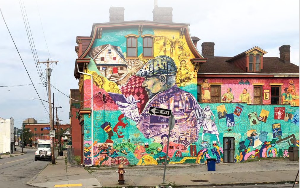
A brightly colored mural decorates the side of a building in the Hill District

In its heyday, the historic Hill District neighborhood was bursting with life. It was full of opportunities and culture; residents treasured it. After slowly cultivating a unique identity through generations and incremental layers of growth, it was nearly destroyed in just a few short years through the building of I-579 and the Civic Arena. Now, 60 years later, some connections are being restored.

A brightly colored mural decorates the side of a building in the Hill District
Mural of playwright August Wilson, who once called the Hill home. Photo from the City of Pittsburgh.

A cultural district cut off from downtown

The Hill District of Pittsburgh, Pennsylvania, located just to the east of the core of downtown Pittsburgh began as a community of freed Black men and women early in the 20th century. As the city’s first Black district, it became a “cultural icon,” known for its jazz scene, radio station, and weekly newspaper, the Pittsburgh Courier. Following World War II, the Hill’s aging housing infrastructure, in conjunction with “crime and disease” (how the city defined it) became the basis to justify drastic urban renewal. Over 95 acres were condemned by the city. Developers came in and began taking houses by eminent domain to “revitalize” the neighborhood. This was the beginning of a swift downfall for the Hill District.
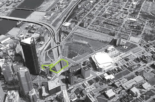
Black and white photographic of a highway cutting through Pittsburgh, with a small segment of the highway outlined in green
Aerial view of Hill District (right) separated from downtown (left) by I-579, with project site for the “cap” connector outlined in green. Historic photo from Pittsburgh-Exhibition Authority.

The plan for I-579, which today cuts directly across Pittsburgh and crosses the Allegheny River to connect with I-279, was conceived almost a decade before any work began. In 1949-1950, there were ongoing conversations about building a highway from Liberty Bridge to Grant Street, at the the end of Bigelow Boulevard. This would cut across the Golden Triangle, enabling a quicker, less congested commute across the city. After a few years of back-and-forth over route and cost, the city and county finally agreed to split the cost of an “82-foot-wide, six-lane expressway.” The City Council passed an ordinance establishing the right-of-way for the partially elevated, partially below grade project, cutting through the Hill District. The repercussions of the expressway on the Hill District were either never considered or blatantly ignored.

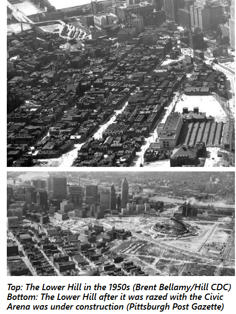
Pittsburgh Post Gazette black and white aerial photographs of the Hill District before demolition (rows of clustered buildings) and after (large, cleared area for the arena and highway)
A before and after of the changes made to the Hill.

In 1957, much to the City Planning Commission’s displeasure, the state announced that Crosstown Boulevard would be part of the newly created national Interstate System and moved forward with a larger, wider highway than they had originally approved, now backed by federal dollars.

The expressway, built in two sections, was completed by 1964. Simultaneously (1961) a new arena (home to the NHL’s Pittsburgh Penguins) and adjacent parking were constructed in the Hill District (South Side). All told, the destruction required to build I-579 and the greater urban renewal efforts resulted in the displacement of over 8,000 predominantly Black residents and 400 locally owned businesses. In addition, almost overnight, the Hill District was cut off from downtown right next door. 

“The massive highway constructed at the base of the arena severed the residents of the Middle and Upper Hill from downtown and any kind of continuity with civic life,” according to this piece in Belt Magazine. For residents of this low-income neighborhood, in a (previously) well-connected central location, walking to work, or walking to access essential needs and services, was no longer an option. By the mid-1980s, the Hill District had “deteriorated into a shell of its former self.”

A path forward: The “Cap” Connector

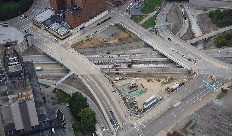
Streets form an open square over another segment of roads
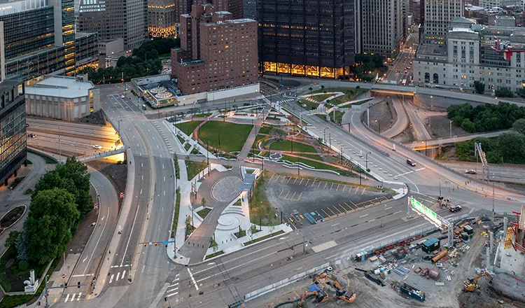
The open square is filled in with green space and sidewalks, allowing pedestrians to walk over land that was once entirely highway

Before and after cap construction. Photos from HDR, Inc.

Today, there is a new cap over a portion of I-579, creating a limited new connection between the Hill and Downtown, restoring access to employment, education, and services—now known as Frankie Pace Park. The cap and park were built (2019-2021) in the open air space above a portion of the below grade I-579 just to the west of the old Civic Arena site The project was initiated by the Penguins’ move into a new arena a few blocks away in 2010, after which the owner of the Penguins demolished the arena and replaced it with 28 acres of parking. The Urban Redevelopment Authority threatened to take one-fifth of the parking revenue unless 6.45 acres were redeveloped by 2020. The Penguin’s owner acquiesced. Approximately half of this land would become Frankie Pace Park, the remainder would be used for mixed-use development.

The space includes bicycle, pedestrian, and ADA access through and around the three acres of land, as well as rain gardens, performance areas, recreation space, and other public amenities. Improved sidewalks, lighting, and signage were included in the project for improved safety and use at all times of the day, as well as curb-cut ramps and enhanced crosswalks at intersections leading into the space.

This project was funded by a combination of federal and state sources including: USDOT through a TIGER (round 8) grant, PA Redevelopment Assistance Capital Program, PA Department of Transportation (Multimodal PennDOT), PA Commonwealth Financing Authority (Multimodal DCED), and PA Department of Conservation & Natural Resources (DCNR Keystone Recreation, Park and Conservation Fund). Several local agencies and foundations also provided funding.1

An additional aspect of this project was its location near an existing subway station, a new bus stop, and a (then) proposed bus rapid transit system (BRT). In March 2023, the Pittsburgh Regional Transit announced approval for the first phase of this project, connecting Downtown, Uptown, and Oakland. Five new stations will be added downtown, including one at Steel Plaza station, made more accessible to Hill District residents by the new park. The electric buses will move along dedicated lanes to ease congestion and improve commuter efficiency.
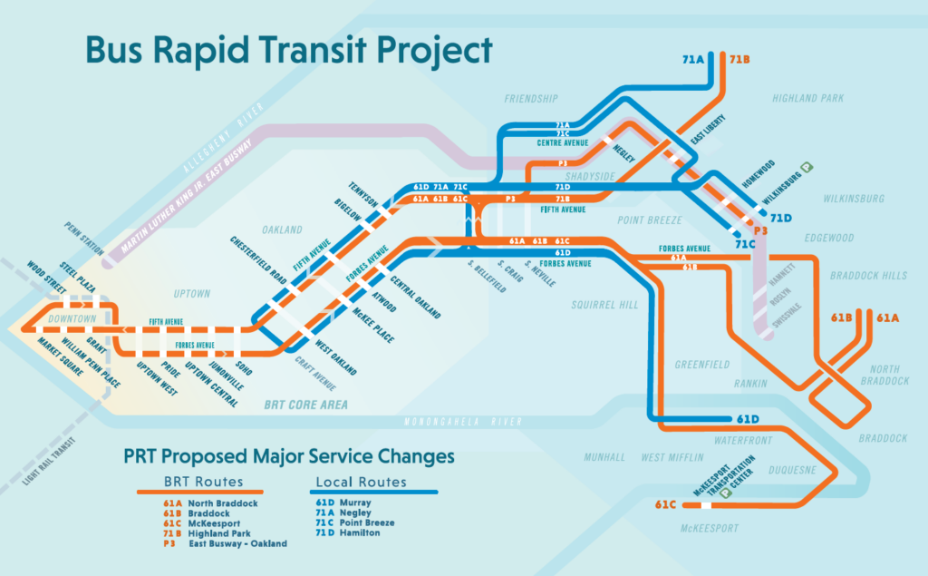
Map of proposed rapid transit (description in caption and in text above)
Map of proposed BRT. The red route indicates bus-only lanes and shows the new proposed stops between downtown (far left) and Oakland (middle-left).

Still more work to do

In August of 2022, Pittsburgh received a federal RAISE grant to further address the harms caused by I-579. Projects funded by the RAISE grant, including curb extensions, new sidewalks, and intersection improvements, will help make the Hill District a safer place to walk for those who are still left in the Hill District.

From the looks of the new park, it can be deemed a success. However, this new park and new connections do not address the issues of past and current displacement and harm that was done to this community over decades, and which continues today.

Lessons for budding community connectors

Transportation and land use are inherently intertwined. As we advocate for development, and redevelopment, and fight to reconnect communities, we must always consider how one variable impacts the others—at the micro and macro levels. The building of I-579 had tremendous repercussions on housing and access (to employment, healthy food, community services, etc). That transportation decision to cut an entire neighborhood off from opportunity to serve thru-commuters had cascading effects on land use decisions across the region. And then 60 years later, the land use decision to create the cap created valuable new transportation connections between the Hill District and downtown. These decisions are inexorably connected.

Projects like these can require significant cooperation and a diverse range of funding sources. Building an interstate is relatively simple—the federal government provides 90 percent of the funding for the project. But Frankie Pace Park, which took nearly a decade to develop, required the cooperation of multiple local, regional, and state agencies, leverage placed on private landowners, and funding from a wide range of sources. Engaging a broad range of stakeholders is required for these complex projects, so get everyone to the table.

The cap is a band-aid on a historical wound. The cap and new park, although successfully built, doesn’t do enough to right historical wrongs and steer the benefits to come from the connection to those who were displaced. The best intentions are no replacement for listening to, including, and prioritizing the voices of those who lost their neighborhood in the first place. Successful reconnecting communities projects should reflect the needs and goals of the existing community, and that can only happen by engaging everyone in the process and empowering them to shape the final product.

Community Connectors: tools for advocates
You may be fighting against a freeway expansion. You may be trying to advance a Reconnecting Communities project to remove an old highway. You might be just trying to make wide, dangerous arterial roads a little safer for people to cross. This Community Connectors portal explains common terms, decodes the processes, clarifies the important actors, and inspires with helpful real-world stories.
The stakes in the states

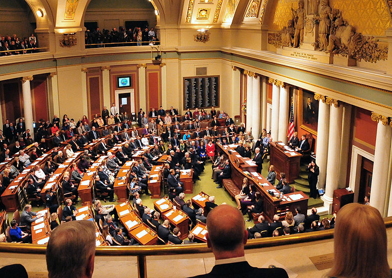
Members of the Minnesota legislature convene in a warmly lit room with gold embellishments and white columns

The next federal transportation reauthorization won’t pass for another three years, but change can still happen at the state level. Here’s why state legislatures play a key role during this time and what they should do with that power.

Members of the Minnesota legislature convene in a warmly lit room with gold embellishments and white columns
Photo from Wikimedia Commons

By passing the Infrastructure Investment and Jobs Act (IIJA, or infrastructure law), the federal government authorized transportation programs through November 2026. There are occasionally new programs proposed, such as Rep. Cori Bush’s BRT Bill, and annual fights to ensure that discretionary programs which didn’t receive advance appropriations are adequately funded. However, Congress’s general dysfunction likely means that no significant new transportation legislation will be passed at the federal level. The infrastructure law left a great deal of power in the hands of the states, and what states choose to prioritize will impact our safety, access, repair, equity, and climate goals for years to come. Therefore, it is a critical time for state legislatures to pick up the slack, and inaction is itself an action.

The state legislature behind the curtain

State legislatures have always had a critical role in determining what transportation networks look like. In many states, a significant portion of the transportation budget comes from state coffers, not federal funds. Illinois and Washington are two states whose legislatures have passed significant spending packages in recent years. In addition, no matter where money comes from, state legislatures have significant leeway over how that money is spent. They can set conditions on spending and conduct oversight of state DOTs whose urban and rural roads are disproportionately deadly. They can also direct state DOTs to spend funds on modes that aren’t just driving, such as investments in rail and subsidizing transit operations.

The passage of the 2021 infrastructure law made state legislatures’ role even more important, as it made a significant sum of money available to the states. However, a significant portion of these federal funds are being distributed through formula programs that don’t come with few strings attached, which means it could easily further entrench the unsafe, unsustainable status quo. Left to their own devices, state DOTs can profess to use that money in the name of good (setting a goal to limit the number of pedestrian fatalities), while ignoring key problems (setting a goal that’s higher than the actual number of fatalities in the previous year). The same could be said for goals of reducing emissions and ensuring that transportation’s inequitable past doesn’t become its future: without state legislative action, much of the funding from the 2021 infrastructure law could be used to make these problems worse.

Importantly, with many legislative sessions coming to an end in 2-3 months, state legislators’ windows for action on a number of these issues are rapidly closing. As federal funds go into state piggy banks, safety, sustainability, and equity could all suffer without sufficient guidance to state DOTs. As funding for passenger rail is distributed, state legislatures risk their state missing out on popular transportation options. At the same time, alarms are sounding from transit agencies facing a fiscal cliff. If state legislatures don’t step up, any promise in the infrastructure law could very well go unrealized.

What state legislators can and should do

The first step state legislators can take is to rethink the status quo on road spending. Rather than building new infrastructure that further divides communities, state legislatures should prioritize maintaining the infrastructure they have built that’s useful, and reconnecting communities where old infrastructure does little more than divide. Rather than getting people to their destinations as quickly as possible, states should prioritize getting them there safely and ensuring they don’t have to travel as far to meet their needs in the first place. These are all specific, clear transportation goals and priorities that state legislatures can direct their state DOT to pursue.

To do this, they simply need to follow the lead of, and improve upon, state innovations that have already been implemented. In Colorado, the Greenhouse Gas Pollution Reduction Planning Rule requires metropolitan planning organizations (MPOs) to plan for greenhouse reductions by limiting projects which will increase emissions and promoting those which expand multimodal options. Minnesota lawmakers are pursuing legislation similar to that of Colorado. In 2021 Maryland established a required baseline for transit maintenance funding, securing it from the whims of annual budget conversations. This is an important step that other legislatures should consider. Relatedly, Virginia’s SMART SCALE is a transportation project evaluation tool that ensures factors like improved safety, increased accessibility, and efficient land-use make a project more likely to get funding from Virginia Department of Transportation. Unfortunately, no state has copied their work yet.

When it comes to passenger rail, state legislatures should take advantage of new, time-sensitive opportunities. The 2021 infrastructure law created the Interstate Rail Compact Program (IRC) to help states work together to develop regional passenger rail networks across the country, as well as the Corridor Identification and Development Program (CIDP). However, given shifts in Congress, both of these programs may receive less funding in future years. Legislators interested in bringing rail service to their state should not allow this opportunity to pass. 

Finally, as transit agencies approach fiscal cliffs over the next few years, state legislatures should move to give them the operating funds necessary to not only maintain current service, but increase it. Although federal Capital Investment Grants are still available to agencies, financial support for operations that the federal government distributed during the pandemic is unlikely to come back any time soon. Any legislature that’s serious about maintaining, if not expanding, the role of transit in their state to avoid increased emissions must provide direct support to agencies for operations.

The bottom line

Transportation spending can be a lot like the game plinko—although a lot of money may be poured in at the top, where it actually ends up depends on decisions made at the state and local levels in between federal reauthorizations. As we approach three-and-a-half years until the next federal infrastructure law, the power over what our transportation system looks like rests in states’ hands.

Advocates can help steer their representatives in the right direction by contacting them and highlighting key transportation concerns. Include specific suggestions on how they can tackle the issue, such as direct more funding towards transit or support policy proposals. During legislative sessions, advocates also have an opportunity to engage through testimony on transportation issues that are most important to them. Ask your state leaders: Will you accept the current deadly, carbon-intensive, community-destroying status quo? Or will you usher in an era of safer, more sustainable transportation that brings our communities together?

Greenville, SC: Out with the cars, in with the people

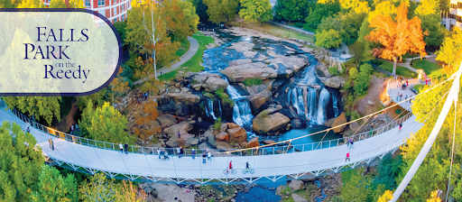
Leaders and residents in Greenville, South Carolina had been working for decades to transform their neglected, denuded downtown into a walkable, dynamic place. But the most significant catalyst was the removal of a highway bridge through downtown and the installation of a beautiful pedestrian bridge in 2004, creating a popular new attraction for people and restoring the city’s relationship to the river that birthed it.

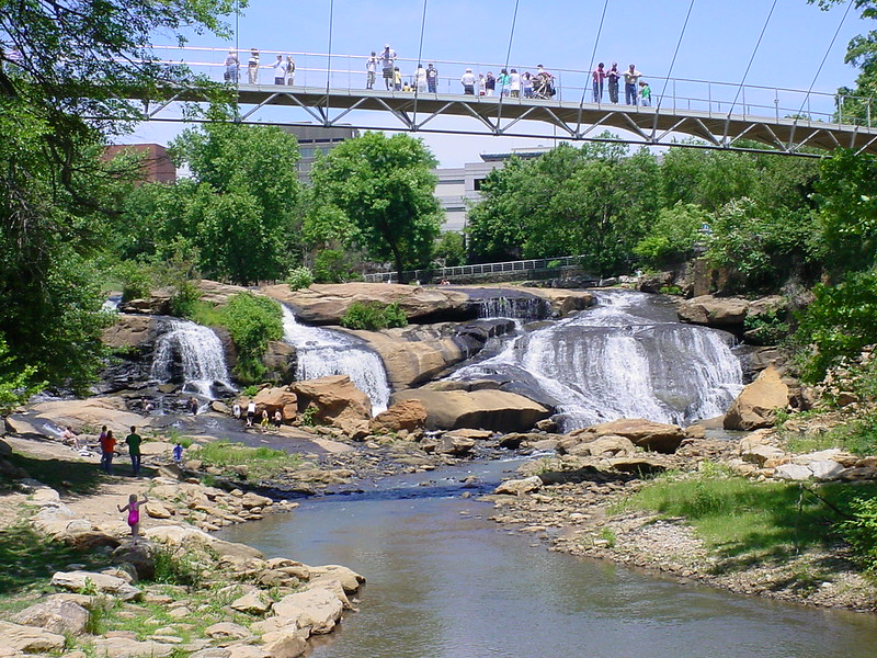
Flickr photo by Doug McAbee

History and context

Greenville, SC emerged from World War II as a thriving mill town. In the 1950s, this prosperity drove development into the suburbs, replacing the residential neighborhoods downtown with department stores and restaurants. While cars were becoming the primary mode of transportation, people continued to return to walkable Main Street, the hub of retail and social life. Many consider this decade to be the economic heyday of Greenville.

The 1960s brought changes to Greenville, similar to many cities across the United States. Increased sprawl, fueled by nearly free federal money for new highways, drove demand for highway access, and decision makers didn’t think twice about displacing residents and businesses to build infrastructure. Following the conventional wisdom of the day, and plenty of assistance from the South Carolina DOT, Greenville was transformed.

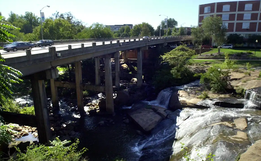
In 1960, the city built the Camperdown Way Bridge, a four-lane highway overpass, across the polluted Reedy River and Falls, the very spot where the earliest settlers gathered and eventually founded the city. Located in the West End section of the city (though technically positioned on the southern end of Main Street), the Camperdown Way Bridge turned this once-warehouse district into “a place you drove through…nothing but derelicts and dilapidated buildings.”2

Camperdown Bridge over Reedy River, with car travel
The Camperdown Bridge. (2000). Photo courtesy of Greenville Online.

Saving Main Street

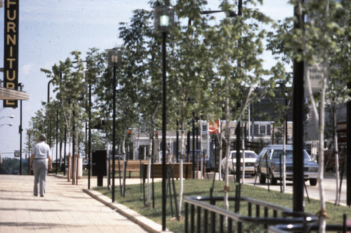
In 1968, the Greenville downtown development plan proposed a redesign of Main Street to create “a pedestrian friendly environment” in the name of economic revitalization. Max Heller, the mayor of Greenville from 1971-79, was determined to bring this plan to fruition. Fighting upstream against the prevailing wisdom of the day when it came to accommodating vehicles at all costs, Heller’s vision of Main Street included a lane reduction (four-lanes to two-lanes), angled parking, street trees, lighting, and widened sidewalks suitable for outdoor dining. His government formed public-private partnerships to maximize success implementing the 1968 plan, and downtown began to flourish. While Heller’s continued influence fostered the extension of Main Street into the West End (1981), the neighborhood lagged behind, continuing to struggle for two more decades.

Main Street Greenville, circa early-1970s. Photo courtesy of The City of Greenville.
Main Street Greenville, circa 1980. Photo courtesy of The City of Greenville.

Restoring the city’s relationship to the river that birthed it

Throughout Greenville’s infrastructure transitions, the Carolina Foothills Garden Club was working on a transition of its own: giving pedestrians, not cars, priority access to the Reedy River and Falls Park and in doing so, restoring the history of the city. But realizing the full fruit of their effort would take decades.

The Club, with support from the City and Furman University, reclaimed the land in 1967. Although still hidden under the unsightly Camperdown Way Bridge, the park began to re-emerge in the 1970s. The shutdown of the mills together with the Clean Water Act (1972) resulted in a much cleaner Reedy River. The following year, 1973, the park was listed on the National Register of Historic Places. This was just the beginning.

In the 1980s, a group of performing artists set their sights on replacing Greenville’s last industrial complex with a center for the arts. The Peace Center, opened in 1990 on the south end of Main Street, is seen as the link between Greenville’s natural resources and Main Street. Its success inspired the Duke Power Company to fund infrastructure upgrades, carrying the feel of Main Street to the West End. Today, a footpath connects Falls Park, the Peace Center, and the West End.

Efforts to tear down the Camperdown Way Bridge began in earnest during the 1990s. The Greenville Central Area Partnership (GCAP) funded a study of the bridge in 1989, with a clear finding that the bridge “needed to come down. It blocked views of the majestic falls…. It divided the area. It made any potential growth moot.”3

This was quickly followed by a city-funded feasibility study in 1990 with outcomes focused on the chaos that would certainly ensue if the bridge was removed, the exorbitant cost to drivers for fuel (due to rerouting)—not to mention the embarrassment of removing perfectly good bridge paid for by the state. In spite of the latter findings, an independent task force recommended removing the bridge in 1991. But there was still a long road ahead.

Replacing a highway bridge with a people bridge

In 1995, Knox White was elected mayor of Greenville (1995-present). A former city council member, White was a longtime advocate for removing the Camperdown Way Bridge. He immediately began using his new position to lobby for removal. Together with his ally in the arts, Virginia Ulderick, White gained support from the governor by showing him the falls on a site visit to the future home of the South Carolina Governor’s School for the Arts and Humanities. The opening of the school (1999) clinched the turnaround for the West End, bringing foot traffic back to the area and strengthening the call to remove the unsightly obstacle standing in the way of resurgence. White next welcomed the head of the state Department of Transportation to visit the school and the park, in an effort to convince the state to give the bridge to the city. Then a state senator. Finally, he began to gain ground.

Even following another traffic study (1998) calling for removal of the bridge, there was still dissent. Naysayers were more interested in roads being fixed, traffic increasing, and any risk of stifling development in the West End just as it was getting going. White recognized the need for a “story,” something beyond tearing down a bridge, something that looked ahead, to the future of Greenville. He found exactly that in the decades-old vision of the Garden Club: a pedestrian bridge over the falls. In 2000, the Camperdown Way bridge became part of the Greenville road system. Greenville published the Reedy River Corridor Master Plan, funded through hospitality tax money, and set about the process of removing the Camperdown Bridge, restoring access to the river, and making the once-hidden falls a showpiece attraction once more. 

Within five years, the Camperdown Bridge came down (2002) and the Liberty Bridge opened (2004), funded through the city council budget. Foot traffic replaced vehicle traffic. Liberty Bridge quickly became known as an architectural and engineering marvel, meant to emphasize the livable, walkable beauty of Greenville.

Falls Park, Greenville, SC (2023). Credit: City of Greenville, Parks, Recreation & Tourism.

Today Greenville, South Carolina is alive with pedestrians. What began with Max Heller’s vision for a walkable Main Street grew to include the beauty of Falls Park. The West End of Greenville is now a thriving mixed-use residential neighborhood, known for its artistic community and proximity to nature. A network of paved trails extends through multiple parks, over Liberty Bridge, around the city, and beyond. While the city is still ringed by plenty of other highways, including another highway viaduct through the heart of the city, downtown Greenville is now a thriving, walkable urban center.

Lessons for Community Connectors

Greenville demonstrates a few impactful lessons for future reconnecting communities projects. 

First, leadership and advocacy from the local government can be the driving force of change. Max Heller and Knox White recognized and fought for the potential they saw in Greenville. They used the power of their positions to change the direction of the community, resulting in economic and cultural success.

Second, partnerships go a long way in achieving a vision. The buy-in of public companies helped initiate the redevelopment of Main Street. Their combined vision and advocacy uncovered the natural beauty for which Greenville is now known. Artists also took part in the collaborative work of connecting nature, downtown, and history.

Third, attractions accessible to both visitors and residents foster success. Paved walking paths connect Falls Park and the Peace Center to each other, to the West End, and to Main Street. In a single walk or bike ride you can be in nature, experience art, dine in a local restaurant, and return to your home or a hotel.

Finally, in the words of Knox White, Find your waterfall!!!” Find what is distinct, what makes your city unique, what features create this “place.” That is the first challenge. Only then can you draw in residents and tourists—who will not just live, work, shop, and dine, but will love this beautiful, walkable, historical (yet innovative), locale.

Urban areas, including but not limited to city centers, grow stronger through investments in walkability (and transit). Urban walkability creates a livable, connected community. Foot Traffic Ahead outlines this concept, using the top 35 largest metropolitan areas as examples. From Greenville, as well as Foot Traffic Ahead, cities can determine which aspects of their predecessors’ paths apply to their own future connected communities.

Community Connectors: tools for advocates

You may be fighting against a freeway expansion. You may be trying to advance a Reconnecting Communities project to remove an old highway. You might be just trying to make wide, dangerous arterial roads a little safer for people to cross. This Community Connectors portal explains common terms, decodes the processes, clarifies the important actors, and inspires with helpful real-world stories.
Assessing safety for the most vulnerable road users

A pedestrian navigates a busy street
Flickr photo by Eric Allix Rogers

Beginning in November of 2023, Vulnerable Road User (VRU) safety assessments will be required as appendices or addendum to Strategic Highway Safety Plan (SHSPs). While the goal of these assessments is to strengthen the Highway Safety Improvement Program (HSIP), recent federal guidance falls short on addressing dangerous road design.

In the United States, pedestrian deaths by vehicles are  at an all-time high, rising more than 50 percent between 2010 and 2020. Change is needed—in road design, in policy, and in policy implementation. Thanks to the highly touted 2021 infrastructure law, there is funding available for improvement, but only if states are willing to budget for safety.

Since 2005, states have been required to set safety measure targets. These targets are intended to help states monitor their progress on road safety, but they face two central issues. First, states can set rising fatality targets—so if fatalities go up, they’ll still be considered “on track.” Second, states don’t face any significant penalty for failing to meet a target. In other words, a state can set a goal to have more traffic fatalities than they had last year, and they face no punishment if traffic fatalities go up even higher than they expected. 

In October 2022, the U.S. Department of Transportation’s (USDOT) Federal Highway Administration (FHWA) released guidance on requirements and recommendations for the Vulnerable Road User (VRU) Safety Assessment. The guidelines are meant to assist states in developing design-focused infrastructure improvements. In comparison to the more general requirement of measuring safety targets, the goal of VRU assessments is to specifically address reducing traffic fatalities and serious injuries on roads that are particularly dangerous for vulnerable road users.

While the guidance is a step in the right direction, limits on data requirements and potential funding streams to implement change will likely hinder the impact of the policy.

Connecting VRU safety assessments to traffic fatalities

The guidance requires states to analyze roadway characteristics in order to identify high-risk areas. Two of the roadway characteristics that must be reported are speed and roadway classification. (Roadway classification relates directly to speed—you’ll never see a freeway where the speed limit is 15 mph, and you’ll never see a residential street where the speed limit is 65.) These are important components of crash data, because the higher a vehicle’s speed, the more likely a crash will end in a fatality.

Watch Smart Growth America’s video on why safety and speed are incompatible goals.

The guidance also requires reporting demographic information—race/ethnicity, income, and age—of the population surrounding the crash area. Fatal crashes disproportionately impact communities of color, the elderly, and low-income individuals, but these impacts are often underreported. If collected effectively, states will be able to more fully consider not only where traffic fatalities occur but who the traffic fatalities impact. An additional category, disability, would further the effort.

In addition to the VRU safety assessment requirements, the FHWA recommends including data such as surrounding land-use patterns, the presence of sidewalks, and the presence of transit stops. These three data references speak to the importance of street design as it relates to pedestrian safety. For example, walking a mile to a bus stop along a busy street without sidewalk access is significantly more dangerous than walking a block on a wide sidewalk.

Projects for high-risk areas

The guidance requires states to propose projects to improve conditions faced by road users in high-risk areas. Complete Streets projects, for example, are proven to reduce safety risks for all street users—pedestrians, cyclists, motorists, and transit riders. Another example of a project aimed at improving road safety for all users is a Road Safety Audit (RSA). The FHWA works with state and local jurisdictions, as well as tribal governments, to conduct RSAs. With guidance and the resources to back it up, jurisdictions do not have to figure out how to meet this requirement on their own.

What’s missing?

Roadway design has a clear impact on safety.  Factors like width, multiple lanes, traffic control at intersections, and the presence of crosswalks all play a part in whether or not drivers speed—and make fatal mistakes. Yet the current guidance does not require states to consider the layout of the road. 

This guidance also fails to provide direction on where to seek funding for safety projects after an assessment is conducted. For example, local public agencies have access to formula funds through the FHWA. States receive 60 percent of their federal highway dollars from the National Highway Performance Program (NHPP). This massive source of funds can and should be used to address designing roads for safety. The Surface Transportation Block Grant (STBG) is another readily available resource, comprising one quarter of the federal money sent to states.

However, these funding sources are often used for projects that make streets more dangerous. Stronger guidance would require states to prioritize funding projects to address the results of safety assessments and provide information on obtaining funding.

Vulnerable road users have the right to expect safety, but by ignoring key design elements, the guidelines fail to provide this. States need to critically assess infrastructure design flaws—and the extent to which they disproportionately impact vulnerable road users—so that funding can be directed towards necessary remedies.

The bottom line

The specific requirements set forth under the new guidance are an overdue upgrade in reporting on vehicle and pedestrian crashes. However, the guidance falls short by failing to require data collection on key safety factors. To address the ongoing crisis of roadway fatalities, states would benefit from more direction, including information on how to access and use their available funds to advance their safety goals.