
The long fight for connectivity in Milwaukee

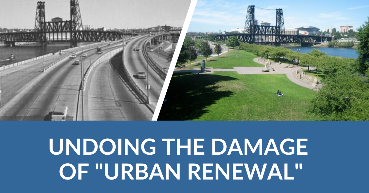
Successfully halting construction on the Park East Freeway in Milwaukee in 1977 was a major early win for advocates. But removing highways is more complicated. Milwaukee confronted that problem in the late 1990s and early 2000s when they attempted to remove the portion that had been built—a story which can serve as a model for other highway removal efforts.

Google Maps street view of a section of North Water Street within the Park East Corridor

Freeways built over communities

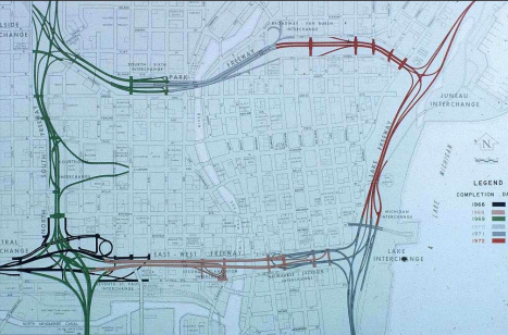
In 1966, officials in southeast Wisconsin had penned the quickly growing area’s first comprehensive regional transportation plan, which called for 16 freeway routes in the seven-county region. Many of those (pictured below) would cut through the city itself, destroying thousands of homes and businesses. The plan was created to rearrange Milwaukee’s transportation system around the growing suburban sprawl of the 1940s and 1950s, with a priority on creating ways for suburban residents to quickly drive into and through the city. The needs of city residents in the neighborhoods those people would pass through were never the prime consideration, if their needs were considered at all.

The Southeast Wisconsin Regional Planning Commission’s 1966 plan for downtown freeway development. The Park East Freeway is the top east-west connection on this map. (Source: City of Milwaukee)

Some Milwaukeeans quickly grew concerned and frustrated over the destruction of thousands of homes, businesses, and parks as the first sections of the region’s freeways were built. One of the most destructive new freeway projects was the Park East Freeway. Black communities, most notably the thriving community of Bronzeville, faced the brunt of the damage and many were largely leveled to pave way for freeway construction. The Park East Freeway destroyed nearly all of what was a thriving community in Bronzeville, which once surrounded Walnut Street west of the Milwaukee River. Other freeways repeated this process across the city.

The staunch opposition of Black Milwaukeeans was ignored by the city and the Southeast Wisconsin Regional Planning Commission (SWRPC), which jointly completed the first section of the Park East Freeway in 1969 — the east/west segment marked in green and gray on the graphic above. As with many other cities, the tide in the fight against freeway construction would turn only when interstates were proposed to be built in whiter, more privileged neighborhoods.

Residents fight to halt construction

In the early 1970s, residents in nearby, primarily white neighborhoods like Sherman Park and Bay View in north Milwaukee organized citizens’ associations to formally resist construction of the Park East Freeway through their communities. These newly formed groups, which had significant resources at their disposal, turned to the legal system to fight the freeways. 

Their legal challenges were enabled by a new law that radically changed the highway construction process. Congress had just passed the National Environmental Policy Act of 1969 (NEPA), which required all construction projects utilizing federal funding to conduct environmental impact studies that measured projects’ impacts on the environment, which included tangible impacts to people in the community. Armed with new NEPA regulations, those wealthy Milwaukee residents were able to not only halt the construction of the Park East Freeway, but successfully got the  SWRPC to institute a ten-year moratorium on all new freeway construction in the region.

This seemed like a major win, but the fight was far from over. Much of the Park East Freeway and other freeways had already been built, crisscrossing the Milwaukee region with damaging road infrastructure that disconnected scores of communities. 

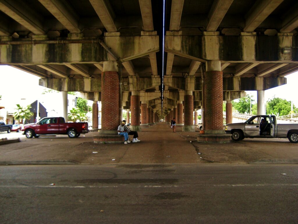
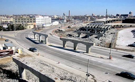
By the time the courts and the SWRPC had halted construction on the Park East, city, regional, and state agencies had already displaced thousands of residents, torn down thousands of homes, and laid miles of asphalt. What was left of the Park East Freeway—a spur of a half-completed highway (pictured below)—remained a gaping hole in the middle of several neighborhoods in north Milwaukee, dividing the people that lived there from neighbors, jobs, and essential services. Repairing these holes would prove to be a greater challenge than halting construction had been.

Removing the Park East Freeway

The former Park East Freeway (Source: City of Milwaukee)

The one-mile spur of the Park East Freeway from I-43 to North Milwaukee Street destroyed or disconnected 17,300 homes and as many as 1,000 businesses. Only a few decades later, the underutilized and expensive freeway would become a clear candidate for removal.

For decades, the area around the Park East Freeway languished in underdevelopment, devoid of essential services or transportation facilities designed to serve the needs of  people living in the area. Developers refused to build anything but surface parking on land adjacent to the freeway, not because parking was in high demand but because other uses were a tough sell right next to the highway. But in 1991, one developer finally took a chance on the area. Mandel Group built a remarkably successful development of luxury apartments and condominiums, selling homes for as much as $500,000. 

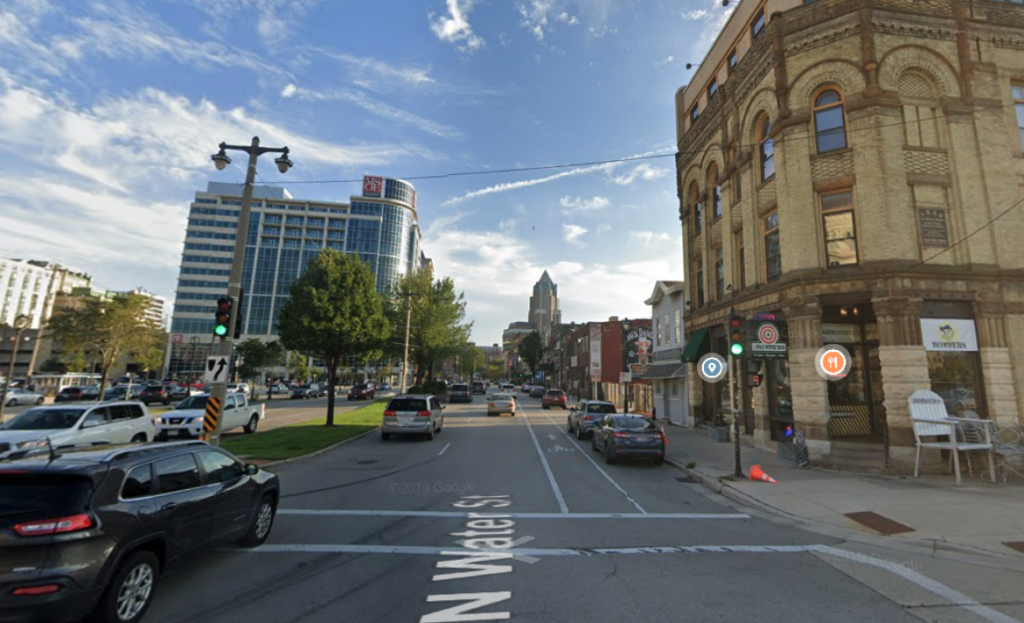
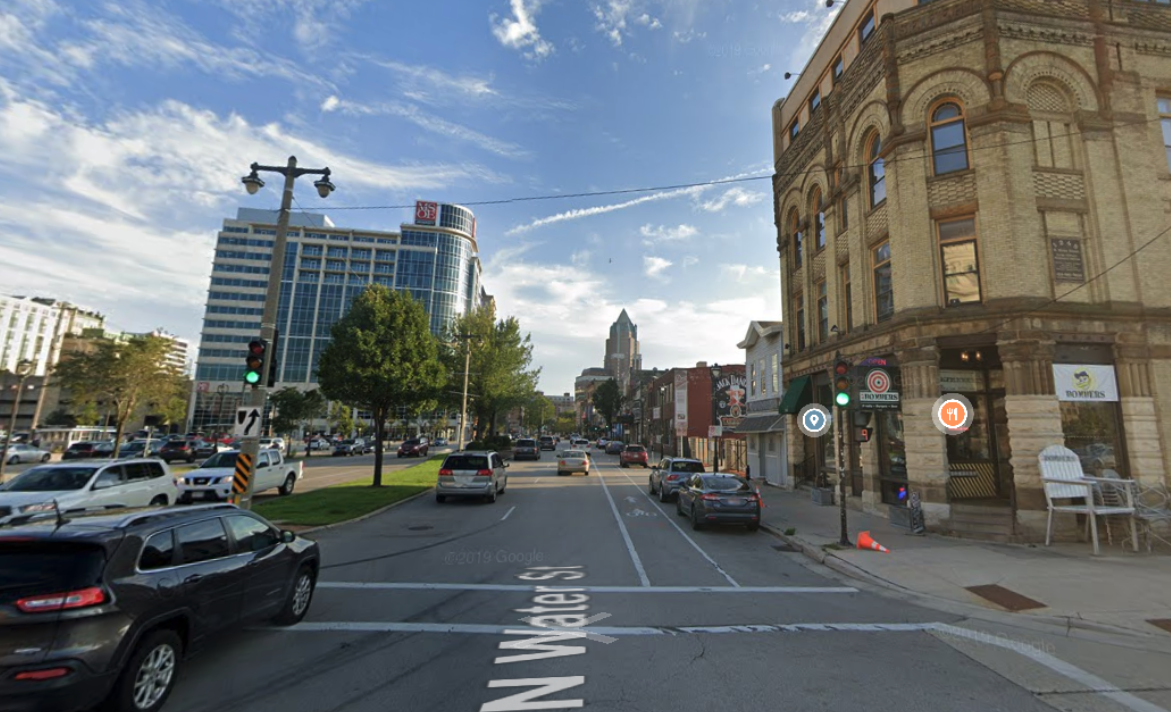
The success of this newly created real estate company—and the buzz of nearby redevelopment activity that followed—caught the attention of Milwaukee’s new mayor, John Norquist. He had been elected to the Wisconsin State Assembly on an anti-freeway platform during the height of Milwaukee’s freeway legal battles of the 1970s, and saw an opportunity to revitalize his home city by removing the old, blighted freeways that divided it. He began drafting a plan to replace the Park East Freeway with McKinley Boulevard, restoring the urban street grid in the area and freeing up 26 acres of land for redevelopment.

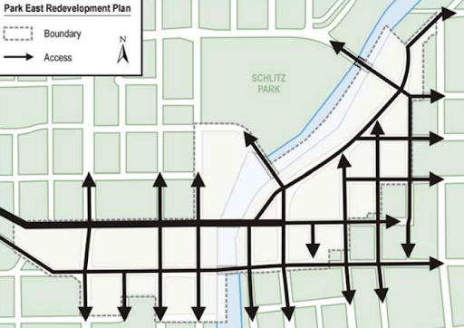
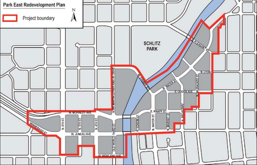
Illustrations of the urban street grid overlaid on the former Park East Freeway right-of-way (Source: City of Milwaukee)

Norquist and his allies, however, still needed to convince other regional and state government agencies to approve the removal project and commit funds to it. They opted to make economic development their core message, proving that removing the freeway would draw new investment and economic activity to downtown Milwaukee. In 1998, they drafted a plan for downtown Milwaukee that tied freeway removal to economic development goals. The plan was approved shortly afterward, in 1999. Another 1998 report, this one by the SWRPC, helped to allay fears that removing the Park East Freeway would increase traffic. The Milwaukee Board of Supervisors and City of Milwaukee Common Council were convinced, approving the plan in quick succession in 1999.

Over the years, NEPA has also been utilized in counterintuitive ways to fight proposed highway removals. The well-researched removal plans helped Norquist’s plan survive one of these NEPA-based legal challenges from local businesses concerned about congestion. And in 2002, the city broke ground to remove the one-mile stub of the Park East Freeway and replace it with an urban street grid—dubbed the Park East Corridor—in 2003. 

Milwaukee funded the project through a compromise with the State of Wisconsin that redirected $21 million in federal highway dollars originally appropriated to the State of Wisconsin for a bus priority lane on I-94. The state matched this money with $1.2 million of its own, and the city followed suit with $2.5 million to bring the full project funding to $25 million. The SWRPC made this agreement official in its 2001 plan, cementing the joint commitment of all three parties toward removing the Park East Freeway.

Park East Freeway being torn down. (Source: City of Milwaukee)

As with other similar projects to remove freeways or highways across the country, the hefty congestion predicted by opponents or skeptics never materialized. Traffic just disappeared, as every state DOT’s expensive models consistently fail to accurately predict. The project was a major success, reducing congestion and attracting billions of dollars in new investment to the Park East Corridor. One block of the new corridor, “Block 22”, has attracted over $3 billion in investment. The corridor was slated to host the 2020 Democratic National Convention before the COVID-19 pandemic spoiled the event. The area has attracted several new corporate headquarters, recently including The American Family Insurance Company

With this proven example in mind, officials in Milwaukee are studying the removal of an outdated portion of State Highway 175 that walls Washington Park off from the Washington Heights neighborhood to the west. As Milwaukee looks to continue healing from its era of roadway-based demolition and division, localities across the country can learn from its successes.

Lessons for budding community connectors

Milwaukee benefitted from a skilled and motivated political leader in John Norquist. Advocates should cultivate political champions of freeway removal of their own, but they also can learn from Norquist’s success in other key ways.

For highways that are still on the books or being advanced toward construction, the NEPA process is as relevant now as it was in the 1970s, still requiring projects of a certain size and scope to engage communities before proceeding. NEPA public engagement processes are a great opportunity for advocacy groups and concerned residents alike to fight for projects that avoid harmful roadway construction. 

Mayor John Norquist succeeded with a simple, well–supported argument for removal that focused on a broadly shared value of economic growth. While Norquist and the coalition supported the project for scores of other worthy reasons and benefits, this economic framing was decisive in convincing skeptical public officials in Milwaukee, the greater region, and Wisconsin state government to approve the project. Local policymakers and advocacy groups should document the benefits of their plans, framing them in ways that will resonate with their communities—and with the people they need to convince. 

While Milwaukee is a good model, it is not perfect. While the destruction of neighborhoods like Bronzeville can never be undone, officials should seek to replace the freeways that destroyed them with development designed to serve the needs of those affected communities. Other communities have prioritized finding ways to restore some portion of lost wealth and income to those who were affected. Milwaukee has developed the Park East Corridor to include luxury apartments and corporate headquarters, but city officials should also seek out ways to provide affordable housing and invest in Black-owned businesses in the area. Undoing the damage created in the first place has to be part of the equation, as does creating a plan from the ground-up with those left behind or neglected, rather than just delivering a top-down plan to them and asking for their support.

But the bottom line is this: resisting and reversing highway construction is possible. The destruction of American communities is not inevitable, and when it happens it need not be permanent.

Community Connectors: tools for advocates

You may be fighting against a freeway expansion. You may be trying to advance a Reconnecting Communities project to remove an old highway. You might be just trying to make wide, dangerous arterial roads a little safer for people to cross. This Community Connectors portal explains common terms, decodes the processes, clarifies the important actors, and inspires with helpful real-world stories.

Watch our webinar: How to Reconnect Communities

On Wednesday, September 14, 2022 at 2:00 p.m. Eastern, we held a webinar to discuss how to maximize the impact of the new Reconnecting Communities Program.

Divisive infrastructure projects, like highways and overpasses built through neighborhoods, continue to restrict travel in cities across the country, creating congestion, hindering development, restricting access to economic opportunity, and worsening public health. Because many of these projects were built in close proximity to communities of color, these communities face disproportionate health, safety, and economic impacts.

In the new infrastructure law, the federal government finally provided a direct funding stream to address this problem. The Reconnecting Communities Program is a valuable federal investment that can begin to move the needle, but the extent of the problem has many wondering if this program’s budget will be enough to make a difference.

Watch our webinar from September 14, 2022 to find out how the Reconnecting Communities Program can be best leveraged to achieve an impact in your community. Director Beth Osborne and Policy Director Benito Pérez will unpack the Reconnecting Communities Program, explaining in clear terms how this program came to be and what it can accomplish. We will also be joined by Erik Frisch, Deputy Commissioner of Neighborhood & Business Development at the City of Rochester, who will describe how Rochester tackled the successful Inner Loop project long before the Reconnecting Communities Program existed, plus share insight into how the city plans to leverage this new source of funding in future projects.

Special guest: Erik Frisch

Erik Frisch is Deputy Commissioner for the City of Rochester’s Department of Neighborhood & Business Development.

In this role since January 2022, Erik oversees the City’s Bureau of Business & Housing Development which is responsible for affordable, market-rate, and mixed-use housing programs, economic development initiatives, and real estate management. Mr. Frisch has been with the City of Rochester since 2007, also serving as Manager of Special Projects in the Department of Environmental Services (2018-2021), overseeing coordination of the ROC the Riverway initiative, a bold plan for Rochester’s urban waterfront along the Genesee River, and the Inner Loop North Transformation, and as the City’s Transportation Specialist (2007-2018), where he managed the City’s transportation planning, traffic calming, and traffic control functions. He has played a key role in many other major City initiatives, including the Inner Loop East Transformation, Bicycle Master Plan implementation, Midtown Rising, and Downtown Two-Way Traffic Conversion. Prior to working for the City, Erik served as a Program Manager with the Genesee Transportation Council for nearly six years. He holds a Bachelors Degree in Geography from Clark University in Worcester, MA and a Masters Degree in Urban Planning from the University at Buffalo (NY).

looping gif showing 2014 view of sunken Rochester inner loop freeway, replaced in second image with current view of new housing and surface streets where freeway once stood

Reconnecting Communities: Initiating restorative transportation justice

Much of the work of smart transportation focuses on playing defense against divisive infrastructure projects that would make travel more difficult. Now, communities and advocates have a small but real opportunity to go on offense and remove or mitigate harmful stretches of transportation infrastructure.

I-10, the Claiborne Expressway, divides the Tremé neighborhood in New Orleans. Flickr photo by Congress for the New Urbanism.

Program overview

On June 30, 2022, the US Department of Transportation (USDOT) released a notice of funding opportunity (NOFO) for the Reconnecting Communities competitive grant program (RCP). States and localities can apply for funding to remove, retrofit, mitigate, or replace an existing expressway, viaduct, principal arterial, transit or rail line, gas pipeline, intermodal port, or an airport that creates barriers to communities. They can also apply for funding to plan such projects.

States and cities have always been allowed to use federal funds for reconnecting communities, but these funds can be used for a variety of purposes, and more often than not, decision makers have opted to build new infrastructure instead of repairing past mistakes. The RCP is unique because it cannot be used for other purposes—it can only be used for the narrow purpose of undoing or mitigating the damage caused by divisive infrastructure, giving advocates a great opportunity to rally local support for reconnection projects.

Removing harmful road infrastructure is important, but so is making space for the community to design what replaces those roads. Grants that include equitable design, community partnerships, intermodal mobility benefits, and anti-displacement strategies are most likely to be selected by USDOT. Full details on these criteria are included in the NOFO.

A tested solution

Projects to reconnect communities are not a new idea. During the interstate highway boom of the 1960s, the city of Rochester, New York constructed a network of highways throughout the city, including the Inner Loop, which destroyed much of the heart of the city. Like in most American cities, this destruction primarily targeted black neighborhoods. 

In 2017, local officials in Rochester decided to try to make things right. They used a combination of federal and local money to convert two-thirds of a mile of Inner Loop East—12 lanes of expressway and frontage road—into one two-lane low-speed street, eliminating bridges and retaining walls while freeing up six acres of land for new development. 

The project was a massive success for both the city budget and local development. It produced $229 million in economic development from only $23.6 million in public investment. It led to a 50 percent increase in walking and 60 percent increase in biking in the surrounding area. On the new land freed up by removing the highway, developers have since built commercial space and 534 new housing units, about half of which are affordable. The removal of Inner Loop East was so successful that the city is now planning to remove another stretch: Inner Loop North.

Rochester is not alone. Syracuse, New York is planning to convert a 1.4-mile stretch of I-81 through its downtown into a “community grid.” Near downtown New Orleans, residents of the historically black Tremé neighborhood have battled for years to remove the stretch of Claiborne Expressway (I-10) that runs through their community (pictured above). The Freeway Fighters Network includes even more communities looking to cap, remove, or even prevent divisive infrastructure.

Every city in the U.S. can benefit from highway removal because every city has its own history of communities being demolished and isolated due to roadway construction. The RCP provides an opportunity for advocates and officials alike to listen to marginalized communities and apply for funding to implement what they need. Rochester and Syracuse can be used as models, but every community will have the flexibility to find an approach that meets their specific needs.

The program’s limitations

The RCP can fund important, restorative projects, but its resources were severely limited by Congress. The program only has $1 billion to give out over the next five years. So this year, USDOT can only award $195 million in grants. For capital construction grants, the minimum grant is $5 million, and USDOT anticipates grants ranging from $5 million to $100 million apiece. So while we do not know the exact number of grants that will be awarded this year, it will likely only be a handful. Planning grants will be awarded at a maximum of $2 million.

USDOT knows funding is tight, so they will designate projects that are well deserving but need more than they can offer as “Reconnecting Extra.” When projects with the Reconnecting Extra status submit future applications for competitive grants like RAISE, they will receive favorable consideration from USDOT. Likewise, if the project is pursuing a TIFIA or a RRIF loan, USDOT will work to consider additional assistance permissible under those loan programs.

We would like to see this program funded more substantially, but the president’s budget and current Congressional Appropriations bill for fiscal year 2023 only allocated the bare minimum. For now, advocates will need to fight hard to make sure their city is selected and demand states and cities make proper use of other federal funds to close the gap.

Transportation for America members have access to exclusive resources that provide further detail on this topic. To view memos and other members-only resources, visit the Member Hub located at t4america.org/members. (Search “Member Hub” in your inbox for the password, or new members can reach out to chris.rall@t4america.org for login details.) Learn more about membership at t4america.org/membership.

A policy proposal to undo the damage of “urban renewal”

Today, Transportation for America and Third Way released a policy proposal to undo the damage of “urban renewal” projects that have displaced more than a million Americans since construction of the Interstate Highway System and that continue to harm communities of color today. These four federal policy recommendations can be included in a COVID-19 stimulus bill or infrastructure package, or considered as stand-alone legislation.

A highway is replaced by a park

So-called “urban renewal” initiatives of the 1950s and 1960s ostensibly provided money to cities across the country to revitalize neighborhoods. But in practice, these new interstates razed housing and ripped through neighborhoods, displacing more than a million Americans during the first two decades of the federal interstate system.1 These projects deliberately targeted communities of color and particularly Black neighborhoods, wreaking havoc on their health and local environments for decades.

The American public has made it very clear that they want the federal government to prioritize revitalizing our nation’s infrastructure. Both parties in Congress and the incoming Biden Administration ostensibly agree on this need. Absent a new approach, however, even re-investment risks perpetuating the inequitable highway construction practices of the past while locking in air, water, and climate pollution that are a drag on our health and the economy.

To undo the far-reaching damage of “urban renewal” projects, Third Way and Transportation for America recommend a suite of policies, including the creation of a new competitive grant program, to reconnect communities, repair the damage, and invest for sustainable and equitable growth. This includes:

  • Creating a competitive grant program to redesign or deconstruct the outdated infrastructure that has hindered the growth of low-income and minority communities;
  • Establishing land trusts to help generate wealth for the communities that already reside in these neighborhoods; and
  • Updating federal transportation modeling tools so that decision-makers and communities can see how these infrastructure projects really impact traffic patterns today;
  • Requiring federal agencies to issue guidance on identifying communities with infrastructure barriers, measuring the degree of harm to that community, and providing incentives and prioritizing resources to address those disparities.

This critical investment could feature in a COVID-19 stimulus bill or separate infrastructure package, or as stand-alone legislation.

Background

After Congress enacted the 1956 Highway Act, cities and states used primarily federal funding to build highways through the middle of cities. White families used these interstates to move to the suburbs. City planners worried that their city centers would empty out if the suburbs were disconnected from downtown, so they intentionally ran new highways downtown to ensure suburban residents would regularly drive into town. But city developers also often deliberately chose highway routes in order to displace, disrupt, or segregate neighborhoods of color.2

The displacement has caused profound and generational impacts on these communities and has created huge physical divides in areas that would otherwise be among the most valuable for the city, especially at a time when cities’ downtowns are revitalizing. These highways destroyed the wealth built up through property by the families whose homes cities took through eminent domain or that developers destroyed. Now, residents cannot enjoy the current benefits of a downtown resurgence because of the infrastructure next to them.3

The urban highways cutting through these communities also brought additional, longer car trips; more congestion on the roads; and more pollution. The air quality issues associated with vehicle emissions disproportionately impact communities of color, with these communities facing higher exposure to harmful pollutants4and greater risk of asthma and other health issues5 than predominantly white communities. These highways, and the sprawl they enabled, have also harmed the climate by increasing Americans’ reliance on motor vehicles: Transportation is now our largest source of greenhouse gas emissions, most of which come from cars and trucks.6

Increasingly, state and local governments are reaching an inflection point. Many of these highways are aged half a century or older and have either fallen into disrepair or are no longer needed because of changing traffic patterns. Rather than simply replace or expand these highways, cities and states should reconsider whether these highways are necessary routes or unnecessary barriers that continue to cut off neighborhoods of color from opportunity.

The idea of legislating to undo the damage of past “urban renewal” policies isn’t new: under President Barack Obama, Transportation Secretary Anthony Foxx convened stakeholder meetings on how to make transportation more affordable, accessible, and equitable.7 President-elect Joe Biden’s inauguration—and House and Senate infrastructure leaders’ commitment to improving America’s roads and bridges—could give new currency to this work.

Policy recommendations

Authorize $10 billion for a new Restoring America’s Neighborhoods Grant program to correct the economic, environmental, and social damage of “Urban Renewal” highway projects that destroyed the core of many small, medium, and large US cities and displaced communities of color.

Half of this funding would be awarded to state DOTs to redesign or deconstruct highways or other transportation infrastructure that was built through communities of color (“obstructive highways”). The other half would fund the creation of land trusts in those neighborhoods to ensure the land freed up from the removal of obstructive highways will generate wealth for the people who already live there.

Redesign or deconstruction of obstructive highways

The US Department of Transportation (USDOT) should make grants available to state DOTs in partnership with the affected cities. Eligible projects for grants under this program would be for removal or repurposing of obstructive highways, including bringing the highway to grade, reconstructing the local roadway network, turning the highway into a boulevard, etc. There should also be a planning set-aside for assessing, designing, permitting and engineering alternatives for specific obstructive highways as well as setting up a land trust, including forming the trust and providing it authority to operate in the area. This work could include measurements of the air and water pollution impacts of retaining or repairing existing disruptive highways versus removing or replacing this infrastructure.

A $5 billion investment could fund a couple of large projects and 6-10 smaller ones, depending on the size of the obstructive infrastructure. These grants will be sufficient to fully fund a project, to ensure these projects can move forward quickly. USDOT should give preference to applicants with a demonstrated capacity—including any locally matched funding—to develop and manage the project; those that have an existing partnership with the communities impacted; and those whose projects demonstrate equitable economic development, a reduction in greenhouse gas emissions, supportive land uses, new transit service, or explicit protection of housing affordability.

To maximize the impact of these investments for economic stimulus, USDOT should reward the first grants no later than nine months after the program is enacted and should strongly prioritize funding to projects that can be completed within 5 years. USDOT should also require projects receiving grant funding to adhere to the labor provisions that usually come attached to federal-aid highway funding, such as Davis-Bacon prevailing wage standards and Buy America domestic content provisions.

Land trusts

The interstates that the Highway Act supported consistently destroyed wealth in the communities they traversed and divided, particularly in communities of color. Therefore, any projects that begin to reverse this damage should rebuild that wealth. Highway update projects that remove a barrier, create new greenspace, or connect the community to commercial centers will also increase land values. To ensure that neighborhoods around the highway receive the benefits of its removal or modification, the project sponsor for any award under this program should be required to establish a land trust or land bank that would receive initial ownership of any property that becomes developable through activities supported by a grant under this program. The land trust would help locals buy the property, preserve and build affordable housing, support the opening of locally-owned small businesses, and preserve greenspace and parks.

A $5 billion investment could support 1-2 dozen land trusts for five years. The sale of property and development of land recovered should both fund the land trust beyond its first five years and help existing homeowners pay the increase in property taxes once their property values appreciate due to gentrification. The program should also protect renters, as well as homeowners who have owned affected buildings for generations but who cannot show title. It must ensure that housing affordability remains protected before, during, and after development. The USDOT should work directly with the Department of Housing and Urban Development to establish the land trust portion of this program, determine awards and manage the grants.

Policy considerations

This paper only introduces the Restoring America’s Neighborhoods Grant program and its key principles; it’s not meant to spell out every detail or present legislative text. However, policymakers and others interested in advancing this program will need to think through some additional policy considerations regarding the land trust component of the program, such as:

  • Whether to include a requirement that the land trust act with a fiduciary duty to the local community;
  • Whether to require that a grantee already have a land trust, or similar non-profit, already established and operating in the area; and
  • Whether to funnel this money through an existing program like the Community Development Block Grant (CDBG) program in order to get funding awarded quickly.

Forecasting tools

Transportation agencies do not yet have the necessary tools to understand the impacts of various highway project alternatives on traffic, urban development, and climate change. Today’s traffic forecasting tools are not built to consider individual trips that shift to other corridors; occur at a different time of day; involve a different mode of transportation; or disappear due to telecommuting or a shifted trip. Our proposal includes $25 million for USDOT to develop twenty-first century tools capable of accounting for these shifts in traffic in order to help plan and to preserve affordability in travel.

Study on obstructive infrastructure

Too many communities suffer the burden of infrastructure barriers without the political or economic power to oppose harmful projects and secure beneficial investments. Meanwhile, the federal government spends billions in formula and discretionary funds, often perpetuating the cycle of harm to communities. To break this cycle, and better target investments, our proposal will require USDOT to conduct a broader study, with the support of state DOTs and impacted cities, identifying the communities with infrastructure that creates barriers to mobility (such as highways that slice through a community) and measuring the degree of harm to that community. This study will culminate in the creation of a national map of communities torn apart by infrastructure, and will help prioritize resources for the communities most badly harmed by obstructive highways in the future.

Examples of successful reversals

Many cities across the country have already removed urban freeways and other infrastructure that has hindered the growth and vitality of their communities. These successes can serve as a model for a federal program.

In the 1970s, Portland became the first major city to remove an existing highway when it tore out Harbor Drive and replaced it with a public park that has served as an anchor for new development. Milwaukee tore down the Park East Freeway in the early 2000s, attracting over $880 million in private investment to the 24-acre corridor. In Greenville, South Carolina, the city replaced a four-lane highway bridge with a pedestrian bridge and public park, a project that revitalized its West End and spurred over $100 million in private investment in its first two years.

The pedestrian bridge in Greenville’s Falls Park on the Reedy that replaced a highway, spurring over $100 million in private investment in its first two years.

There are also examples of communities establishing land banks to bring economic value to low-income communities and communities of color and help underserved families stay in their homes. Launched in 2003, Denver’s Urban Land Conservancy preserves and develops permanently affordable real estate to ensure underserved communities are not displaced by rising property values. Through the conservancy and other partners, the Denver Transit-Oriented Development Fund is working to secure over 1,000 affordable housing units on transit corridors. In Minneapolis, the Twin Cities Community Land Bank has acquired at least 1,000 vacant or distressed properties since 2009, keeping these properties affordable and helping low-income families stay in their homes.

Positive impacts

The United States has an opportunity to replicate these success stories by providing cities with the proper resources and tools to tackle these projects. Through a $10 billion program, dozens of cities could plan and repurpose their disruptive highways and reclaim significant acreage for tax-paying, job-creating redevelopment.

This grant program would improve regional air quality and health outcomes in disadvantaged communities by reducing exposure to smog. It would reconnect impacted neighborhoods, create new open spaces and allow people to take shorter trips to reach daily necessities like the grocery store or community center. It would increase access to less polluting modes of travel, like walking and biking. It would reduce climate pollution in areas that research already indicates will suffer a greater burden from the impacts of climate change. Most importantly, it would be a step toward rectifying the mistakes of past federal policy and moving us forward in a brighter direction.

Endnotes

  1. Pyke, Alan, “Top infrastructure official explains how America used highways to destroy black neighborhoods.” Think Progress, 31 Mar. 2016, https://archive.thinkprogress.org/top-infrastructure-official-explains-how-america-used-highways-to-destroy-black-neighborhoods-96c1460d1962/.
  2. Kruse, Kevin M, “What does a traffic jam in Atlanta have to do with segregation? Quite a lot.” New York Times Magazine, 14 Aug. 2019, https://www.nytimes.com/interactive/2019/08/14/magazine/traffic-atlanta-segregation.html.
  3. Semuels, Alana, “The role of highways in American poverty.” The Atlantic, 18 Mar. 2016, https://www.theatlantic.com/business/archive/2016/03/role-of-highways-in-american-poverty/474282/.
  4. De Moura, Maria Cecilia Pinto and David Reichmuth, “Inequitable exposure to air pollution from vehicles in the Northeast and Mid-Atlantic.” Union of Concerned Scientists, 21 Jun. 2019, https://www.ucsusa.org/resources/inequitable-exposure-air-pollution-vehicles.
  5. “Disparities in the impact of air pollution.” American Lung Association, 20 Apr. 2020, https://www.lung.org/clean-air/outdoors/who-is-at-risk/disparities.
  6. “Fast facts on transportation greenhouse gas emissions.” U.S. Environmental Protection Agency, accessed 4 Dec. 2020, https://www.epa.gov/greenvehicles/fast-facts-transportation-greenhouse-gas-emissions.
  7. Beyond Traffic 2045, U.S. Department of Transportation, 9 Jan. 2017, page 206, https://www.transportation.gov/sites/dot.gov/files/docs/BeyondTraffic_tagged_508_final.pdf.