
When gas prices rise, choice matters

Chevron gas station with gas prices ranging from $6.39 to $6.69

High gas prices put pressure on many Americans’ finances. Unfortunately, the cost of gas depends on a variety of factors, and there’s no silver bullet. Focusing on ineffective short-term solutions can often distract from the long-term problem: when the places we live are designed only for car travel (and longer trips), Americans are forced to pay the cost.

Chevron gas station with gas prices ranging from $6.39 to $6.69
The cost of gas in Aptos, CA climbed above six dollars in March of 2022. Prices are continuing to rise. Photo from Flickr/rulenumberone2.

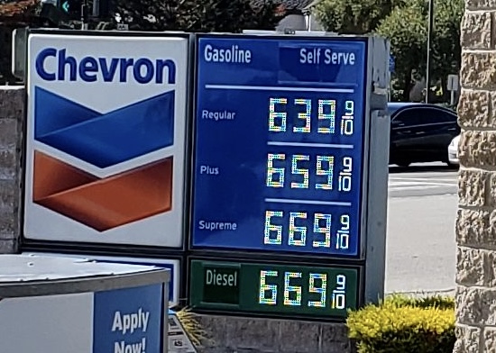
Gas prices have been rising throughout the year, nearing an all-time inflation-adjusted US high. Millions of Americans who rely on a vehicle for essential trips also may depend on low gas prices to make ends meet. Under pressure, state and federal legislators are trying to find ways to drive down the price, including passing gas tax holidays and proposing a federal price gouging bill. However, a variety of factors influence gas prices, and these legislative efforts have little chance of stemming the tide. Gas tax holidays are a particularly shortsighted choice. They threaten funding for needed infrastructure projects, many of which could ultimately alleviate pain at the pump.

Electric vehicles can’t be the sole answer to this problem either, because the issues that come up when people have to drive everywhere, even for the shortest trips, aren’t limited to the cost of fuel. All that driving takes up valuable time. Cars take up space on the road, which turns into traffic, making travel last even longer. It’s expensive to purchase and maintain a car, and when people have to own cars to travel, those who can’t afford one or are unable to drive one are left stranded. (We wrote about some of these issues in our report Driving Down Emissions.)

Every presidential candidate's climate and transportation plan: replace all cars on the road with EVs, akacleaner congestion

Regardless of the cost of gas, it’s never been cheap or convenient to rely solely on driving for daily travel. Whether electric or gas-powered, cars are expensive, and Americans have to drive them further than ever just to access their daily needs—Americans in the biggest metro areas are driving 20 percent more per day than three decades ago.

While gas tax holidays will fail to provide significant relief (and cut revenues for roads and bridges in the process), there are enough other organizations and economists and elected leaders trying to figure out short-term solutions for these historically high prices. We’re taking the long view.

Last year’s infrastructure law, a historic investment in our nation’s transportation system, could provide longer lasting solutions for struggling travelers who need to save time and money at the pump.

The infrastructure law made new funds available to improve transit speeds and access, reconnect communities separated by dangerous infrastructure, and design safer and more active streets. We’ve written before about how these changes can enhance equity and improve climate outcomes, but there’s another benefit we might not bring up enough: more options mean more ways for travelers to save on transportation.

When people live in walkable, multimodal places (of nearly any size) where destinations are located closer together, they can walk, roll, or take the bus to get to work, school, and the grocery store. As gas prices rose, people in these sorts of places, whether affluent or lower-income, were fortunate enough to be able to take much shorter trips by car or switch to other modes of travel. In doing so, they avoided some of the rising cost of car travel, even if they occasionally drove.

After 2008, the last time gas prices rose, we had a similar opportunity to make lasting changes to our infrastructure. Demand rose for alternative modes of travel, especially in areas that already had long-established alternate options. If we had invested in multimodal transportation, we’d be in a very different situation today. But we didn’t—and this is where we ended up. 

Because much of the funding in the infrastructure law is flexible, we can use it to give travelers more choices. Or we can further entrench ourselves in a system that requires more driving, more pollution, and more unexpected costs. Those choices will be up to states and metro areas as they decide how to invest these funds. 

To really address the climbing cost of car travel, state DOTs and metro areas need to make sound infrastructure investments. If they merely use the infrastructure law to supercharge their existing work to prioritize speedy, long-distance travel at the expense of shorter trips via a range of modes, we’ll be right back in this mess the next time gas prices rise. When that time comes, we’ll know who deserves at least some of the blame.

Walk Score expands into Transit Score; housing plus transportation costs

An exciting new service that launched this morning from our friends at Walk Score will help people all across the country find out how transit-accessible a home or a neighborhood is while gaining a better understanding of the true cost of buying a home — the cost of housing plus transportation.

Starting today, when you visit Walk Score you’ll also get information about nearby transit options, commuting details, and the expected cost of housing plus transportation. Some of the new features:

  • A Transit Score for the 40+ cities that provide open transit data. See the list of cities here
  • By entering a work and home address, you can get custom commute reports for all cities showing hills on your route for biking or walking, nearby transit lines, and travel times and directions based on mode. Select walking, biking, transit or driving and see the route update dynamically. (See example below)
  • They’ve also joined with the Center for Neighborhood Technology to allow users to calculate their expected transportation costs to give a fuller picture of the cost of a home.
  • They’re partnering with the real estate site ZipRealty to have this provided with all of ZipRealty’s home listings. So anyone looking for a home on their site will get exposed to these ideas on a regular basis.

Together with the Center for Neighborhood Technology, Walk Score and CNT have done more than almost anyone to help raise the visibility of the issue of housing and transportation costs in the minds of consumers and adding transit to the mix is the next obvious step. After all, you may live in a neighborhood with a 75 Walk Score but you’re a five minute walk away from a bus or train that can take you to a neighborhood with a 100 Walk Score in just a few more minutes. Being able to walk to and use a variety of of other transportation options expands your “walkshed” — something that Walk Score doesn’t recognize on its own.

When you search for the Walk Score now, you also get a Transit Score. And if you live in one of the 40 cities with open transit data, you can enter a second address and get a commute report, complete with directions. As an example, here’s a commute from a neighborhood north of downtown D.C and the T4 America office., where some of our staff live and ride their bikes to work. Click on the bike commute, and it shows you the profile of the hills, the time and mileage, and the route on a map:

These commute reports will be available for all cities, though the transit data will be left off for cities without open data.

Now I know what you’re thinking: only 40 cities with transit data? Indeed, Transit Score unfortunately only has access to a limited set of open transit data, because not all agencies have chosen to open up this publicly-owned data as a public resource. But there’s hope. You can petition your local transit agency to release their data publicly to make exciting tools like this and others possible. Visit www.citygoround.org to see a list of the 695 agencies with no open data and find information on how to request your local agency provide that data. (Read our post about the release of CityGoRound.)

Transit Score was supported by the Rockefeller Foundation, and had this to say in the official press release this morning:

“The Rockefeller Foundation’s transportation initiative is committed to helping Americans re-think our transportation future as a way to expand economic opportunity, and we are excited about the potential impact Transit Score will have in helping Americans make more informed decisions about where they will live and work,” said Benjamin de la Pena, Associate Director at The Rockefeller Foundation. “Transportation costs are often the second highest expense for working Americans and Transit Score will give families more control over their household budgets by providing them with information about their transit choices.”

The housing+transportation calculator is cool, but at the risk of going on too long on a Monday morning, if you really want to dive into finding out more about housing and transportation costs today, you need to check out Abogo from the Center for Neighborhood Technology. Type in an address, and it gives you the cost you can expect to pay for transportation at that address and an estimate on emissions. With one glance at the color, you can see where transportation costs are low, and where they are higher, helping to make a more informed decision.

These kinds of tools are certainly important for helping consumers make more informed decisions when purchasing a house, but the greatest value is really what they do to help shatter the myth that the cost of a home is the only major cost of a home. With multiple trips taken each day to all the places we need to go, the locations of our homes have profound impacts on our pocketbooks, wallets and time. We applaud Walk Score, Transit Score and CNT for working hard to make the case that we need more walkable, transit-accessible places in our communities — and that the market is demanding them.

Housing and transportation squeeze hitting rural America, new reports concludes

When the Center for Neighborhood Technology released its revised Housing and Transportation Index last week, much of the focus naturally tilts toward cities due to the measurement of metropolitan areas. But CNT’s rural companion report on transportation costs in less-populated areas deserves ample attention as well.

The transportation challenges for rural America have more to do with factors like access and opportunity than congestion and traffic. With volatile energy prices and longer distances between employment, groceries and health services, transportation choices are essential. More than 1.6 million rural households do not have access to a car, making routine trips a strain on a family’s time and budget. For those who do drive, high gas prices take a big chunk out of monthly incomes. Rural residents with cars drive about 17 percent more miles each year than their urban counterparts.

CNT’s analysis finds rural residents feeling squeezed in every corner of America, from Alaska to Alabama. In the areas near Billings, Montana, average annual household gas expenses have reached $5,300 per year, up from just $2000 per year just a decade ago. Costs shot up $3,200 between 2000 and 2008 in Hattiesburg, Mississippi. In the rural pockets surrounding Las Cruces, New Mexico, costs were up $3,100. In the image below, turquoise  indicates Billings-area communities where yearly housing and transportation costs exceed the 45 percent threshold.

The CNT formula defines true affordability as less than 45 percent of household income going toward housing and transportation costs combined.

The website features profiles of communities in both rural and metro areas alike.

CNT’s three recommendations for inclusion in a new transportation bill are: 1) making transportation costs as transparent as possible; 2) using a similar yardstick as the true affordability in future policies and funding priorities for transportation; and 3) increasing incentives for projects that increase transit options and proximity to employment and housing. Support for passenger rail and intercity buses — both heavily-relied upon in sparser parts of the country —can and should fit under these policy umbrellas.

But rural livability is much more than just a discussion topic in Washington D.C.  Stephen Lee Davis of Smart Growth America (and a Transportation for America colleague,) recently wrote about his experience living in Bentonville, Arkansas, a medium-sized town known best as the world headquarters for Wal-Mart Stores. In a two-part series on the Smart Growth America blog, Steve questioned the political figures who see livability as disconnected from America’s rural areas and small towns:

…for me and my wife and many others living in the older part of the city [street grid] in those weeks [in 2005] with astronomical gas prices, a pretty normal life was still possible, even while trying to cut back driving significantly to save money. Several weekends in a row, we parked our cars entirely, and managed to do our grocery shopping, go to church, visit friends, or listen to bluegrass in the square on a Friday night without having to get in either of our two cars. We walked 5 minutes to the grocery store. We biked to Walmart a handful of times — receiving many strange looks in the process. We went to eat at a new restaurant on the square. We went hiking on a short trail in the woods right on the edge of downtown. We went to the library.

Sounds pretty “livable,” right?

…and explained how current transportation policy has failed the residents of towns like Bentonville.

People who live in classic American small towns like Bentonville know a thing or two about livability. There’s nothing “livable” about being stuck in your subdivision that got built too far from town, work or school when gas prices get too high. Nor is it “livable” to have the federal government incentivizing (through money to the State DOT) the widening of highways into the county to encourage more sprawl outside of town even as the city is clamoring for more investment inside of it.

Like their urban counterparts, many residents in rural areas and small towns hope to preserve what they love about their way of life while making it easier to get by — and get around. CNT’s work helps to bring those challenges to light and move policy in a direction that produces results.