
More on the engineering metric that has an outsize impact on the design of our communities
California changed how the state measures the performance of their streets in 2013, shifting away from a narrow focus on moving as many cars as fast as possible — level of service (LOS) — and taking a more holistic view and measuring their performance against a broader list of other state goals that were often in conflict with LOS. But what is LOS? How does it impact how communities can design their streets?
In this second post of a longer series on level of service (LOS) only for T4America members, we walk through this metric in more detail and explain how it often works against a state’s, metro area’s or city’s other stated goals. Read the first post here.
Introduction
You may be familiar with this story: a community has plans to rejuvenate the economy by redesigning the local street (yet also state highway) running through its downtown, only to be told by the state department of transportation (DOT) that their proposed changes will slow down traffic and doesn’t rate high enough on their metrics to make it onto the short list of projects. Worse yet, the community is told that in order to make a street safer, they actually need to widen it and smooth out any curves, making it a virtual speedway, which would undercut the economic development opportunities.[1]
How do DOTs come to this conclusion that the proposed changes or new development would cause the roadway not to perform well? Most DOTs, metropolitan planning organizations and traffic engineers rely on a metric known as level of service (LOS). According to Jason Henderson, professor of geography at San Francisco State University, “Every city I’ve ever come across has some use of [LOS].”[2] Because of the ubiquity of LOS, this largely misunderstood measurement has profound influence on the design of our communities.
What is level of service?
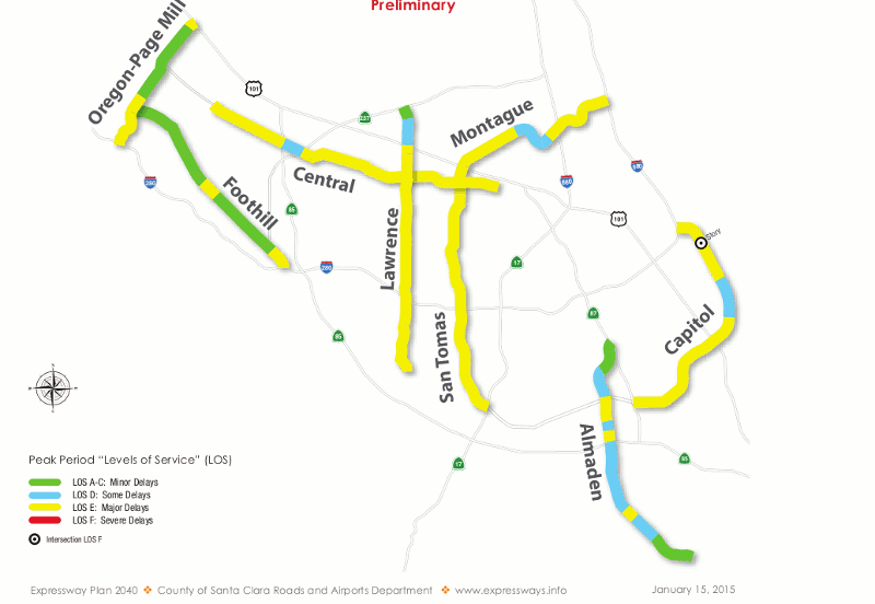
Level of service is a system by which road engineers measure road performance on a graded scale of A through F. LOS measures how well a road is performing based on the number of cars and the delay automobiles experience on that roadway. Letters designate each level, from A to F, with LOS A, B and C representing free flowing conditions, while LOS F is stop-and-go traffic.[3] The score is assessed based on the highest level of congestion on that roadway, even if it only occurs a few minutes a day. Traditionally, roadway conditions are acceptable if they score a C or higher on non-urban streets and a D or higher on urban streets.[4]
Example of level of service graphic[5]
The LOS measurement is calculated by first measuring the amount of traffic during the busiest 15 minutes of an evening rush hour. Then traffic engineers project the amount of traffic on the road in 20 or 30 years using the result of that measurement to determine if the road has enough capacity to cover the lifespan of that asset.[6]
One surprising aspect of the usage of LOS that many people don’t realize is how LOS is not just about how a road functions today. If a road is projected by traffic engineers to lack capacity 20 years in the future — an incredibly fuzzy practice that’s more art than math — that road still receives a failing LOS grade today, even if the road is adequately suiting capacity needs.[7]
The history of LOS
The 1965 federal Transportation Research Board Highway Capacity Manual introduced the LOS metric and it quickly became accepted as the standard measure of roadway performance.[8] One reason that states adopted the LOS so quickly was that it suited the country’s transportation goals in the 1960’s of building out a network of interstates and prioritizing automobiles to travel.[9]
Although LOS became the standard, transportation agencies at any level are not explicitly required to use it: there are no planning or project design requirements that mandate the use of either LOS or travel modelling. Planning manuals from both the the Association of American State Highway and Transportation Officials (AASHTO) and the Federal Highway Administration “clearly state that these are guidelines to be applied with judgment — not mandate(s)”[10]
It is important to point out that although LOS was initially meant exclusively for highways and cities aren’t required to abide LOS as a course of law, over the years the measure has hardened into convention for all roads. The adoption of this convention means that LOS has routinely been used for the design of city streets.[11] Eric Jaffe of Atlantic Cities in 2011 noted that “By the time cities recognized the need for balanced transportation systems, LOS was entrenched in the street engineering canon.”[12]
What’s next in the series on LOS?
In our forthcoming third post in this series, we will explain in more practical detail how LOS has damaged communities, organizations, and advocates promoting smart-growth. As Gary Toth from the Project for Public Spaces brilliantly put it, transportation professionals, “in search of high LOS rankings have widened streets, added lanes, removed on-street parking, limited crosswalks, and deployed other (anti-smart growth) strategies” all because LOS has been the de facto standard over the last 50 years.[13]
If we are going to change the way our streets and communities are designed, we will need to change the way we measure their performance.
Citations
- [1] See for example highway 23 in Wisconsin: http://wisconsindot.gov/Pages/projects/by-region/ne/wis23corridorsheb/default.aspx or Interstate 59/Interstate 20 in Birmingham Alabama: https://t4america.org/2016/02/02/alabama-dot-out-of-step-with-metro-business-leaders-on-economic-development/
- [2] Jaffe, E (2011, December 5th) “The Transportation Planning Rule Every City Should Reform”. Citylab. Retrieved 2/03/2016 from http://www.citylab.com/cityfixer/2011/12/transportation-planning-law-every-city-should-repeal/636/
- [3] Transportation Research Board (2000). Highway Capacity Manual. Retrieved 1/25/2016 from City and County of San Francisco Office of Community Investment and Infrastructure at http://www.gsweventcenter.com/Draft_SEIR_References%5C2000_TRB.pdf
- [4] Toth, G “Levels of Service and Travel Projections: The Wrong Tools for Planning Our Streets?” Project for Public Spaces. Retrieved 1/25/2016 from http://www.pps.org/reference/levels-of-service-and-travel-projections-the-wrong-tools-for-planning-our-streets/
- [5] Creative Commons Santa Clara County Expressway Level of Service Map by Richard Masoner is licensed under CC by 2.0. Retrieved February 3rd
- [6] Roth, Matthew (2009, January 26th) “Paradise LOSt (Part I): How Long Will the City Keep Us Stuck in Our Cars?”. Streetsblog. Retrieved 1/25/2016 from http://sf.streetsblog.org/2009/01/26/paradise-lost-part-i-how-long-will-the-city-keep-us-stuck-in-our-cars/
- [7] Ibid Toth, G “Levels of Service and Travel Projections: The Wrong Tools for Planning Our Streets?”
- [8] Jaffe, E (2014, July 8th) “Transit Projects Are About to Get Much, Much Easier in California”. Citylab. Retrieved 1/25/2016 from http://www.citylab.com/commute/2014/07/transit-projects-are-about-to-get-much-much-easier-in-california/374049/
- [9] Ibid Toth, G “Levels of Service and Travel Projections: The Wrong Tools for Planning Our Streets?”
- [10] Ibid Toth, G “Levels of Service and Travel Projections: The Wrong Tools for Planning Our Streets?”
- [11] Jaffe, E (2011, December 5th) “The Transportation Planning Rule Every City Should Reform”. Citylab. Retrieved 1/25/2016 from http://www.citylab.com/cityfixer/2011/12/transportation-planning-law-every-city-should-repeal/636/
- [12] Ibid Jaffe, E (2011, December 5th) “The Transportation Planning Rule Every City Should Reform”
- [13] Ibid Toth, G “Levels of Service and Travel Projections: The Wrong Tools for Planning Our Streets?”