What would the national reaction be if a jumbo jet full of passengers went down with regularity every 31 days or so? How loud would the calls be for a fundamental change in airline safety? It’s easy to imagine the shock and outrage if such a thing happened. Yet that is essentially what happens every year with preventable pedestrian fatalities on our nation’s streets and roads.
Every year, nearly 5,000 Americans die preventable deaths on roads that fail to provide safe conditions for pedestrians. This decade alone, more than 43,000 Americans – including 3,906 children under 16 – have been killed while walking or crossing a street in our communities. With more than 76,000 Americans dying in the last 15 years, it’s the equivalent of a jumbo jet going down roughly every month, yet it receives nothing like that kind of attention.
A new report from Transportation for America and the Surface Transportation Policy Partnership, Dangerous by Design: Solving the Epidemic of Preventable Pedestrian Death (and Making Great Neighborhoods), ranks metropolitan areas based on the relative danger of walking.
Download the full report, see the comprehensive rankings and view all of the companion tables of data online right here: https://t4america.org/resources/dangerousbydesign. After you’ve taken a look, ask U.S. Transportation Secretary Ray LaHood to make pedestrian safety a priority for the administration. Pedestrian deaths are preventable, and we demand safer streets!
Many of these preventable deaths are occurring along roadways that are dangerous by design, streets engineered for speeding cars with little or no provision for people on foot, in wheelchairs or on a bicycle.
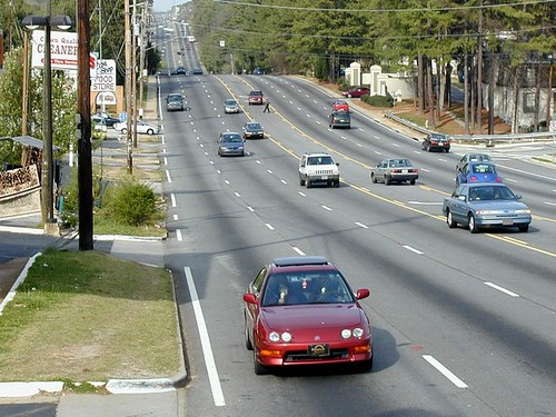 |
YikesPedestrian Originally uploaded by Transportation for America
|
Look carefully in the turning lane above the center of the photograph. There’s a pedestrian trying to cross this 7-lane urban arterial road. See any crosswalks anywhere on the road? Photo courtesy of Dan Burden.
|
Over the last several decades, many of our cities and communities have seen the same shift of daily business from walkable, downtown Main Streets to wide, fast-moving state highways. These “arterial” roads are the new main streets in most communities, drawing shopping centers, drive-throughs, apartment complexes and office parks. Unlike the old walkable main streets, however, the pressure to move as many cars through these areas as quickly as possible has led transportation departments to squeeze in as many lanes as they can, while disregarding sidewalks, crosswalks and crossing signals, on-street parking, and even street trees in order to remove impediments to speeding traffic.
As a result, more than half of fatal vehicle crashes occurred on these wide, high capacity and high-speed thoroughfares. Though dangerous, these arterials are all but unavoidable because they are the trunk lines carrying most local traffic and supporting nearly all the commercial activity essential to daily life.
Before the top 10 most dangerous city rankings, here are just a few facts you might like to know:
Inadequate facilities. Of the 9,168 pedestrian fatalities in 2007-08 for which the location of the collision is known, more than 40 percent were killed where no crosswalk was available.
Spending disparity. Though pedestrian fatalities make up 11.8 percent of all traffic-related fatalities, states have allocated less than 1.5 percent of total authorized transportation funds to projects aimed at improving safety for pedestrians (for funds spent under current transportation bill.) No state spends more than 5 percent of federal transportation funds on safety features or programs for pedestrians or cyclists, despite a 30 percent increase in total federal transportation dollars beginning in 2005.
Complete streets save lives. Providing sidewalks, crosswalks and designing for lower traffic speeds saves lives. Only one in 10 pedestrians deaths occurred within crosswalks, while six in 10 occurred on arterial-type roads where speeds were 40 mph or higher.
The danger is not shared equally. Older adults, disabled and low-income Americans are being killed at disproportionate rates. African-Americans, who walk for 50 percent more trips than whites, and Hispanic residents, who walk 40 percent more, are subjected to the least safe conditions and die disproportionately.
Aging in place, yet unable to leave the house on foot. An AARP poll of adults 50 years and older found that 40 percent reported inadequate sidewalks in their neighborhoods and nearly half of respondents reported that they could not safely cross the main roads close to their home.
| Rank |
Metropolitan Area |
2007-08 Pedestrian
Danger Index |
| 1 |
Orlando-Kissimmee, Fla. |
221.5 |
| 2 |
Tampa-St. Petersburg-Clearwater, Fla. |
205.5 |
| 3 |
Miami-Fort Lauderdale-Pompano Beach, Fla. |
181.2 |
| 4 |
Jacksonville, Fla. |
157.4 |
| 5 |
Memphis, Tenn.-Miss.-Ark. |
137.7 |
| 6 |
Raleigh-Cary, N.C. |
128.6 |
| 7 |
Louisville/Jefferson County, Ky.-Ind. |
114.8 |
| 8 |
Houston-Sugar Land-Baytown, Texas |
112.4 |
| 8 |
Birmingham-Hoover, Ala. |
110.0 |
| 10 |
Atlanta-Sandy Springs-Marietta, Ga. |
108.3 |
|
|
See the full rankings and download the report |
Washington D.C. took another great stride towards making bicycling easier and more attractive with the grand opening of Union Station’s BikeStation almost two weeks ago. With the opening of the stunning facility at Union Station, Washington’s most visited destination and travel hub can now connect commuters using trains, buses, cars, subway, or bikes.
(As Ray LaHood said, it’ll help address that “last mile” problem of commuting.)
The BikeStation offers a brand new option for commuting. A train or metro rider can now leave their bike at Union Station without it being stolen, stripped for parts, or damaged by weather. Thus, any commuter who can get to Union Station can now pick up their own, well-maintained bicycle and use it for commuting around Washington.
In New York City, the DOT found out that a safe and secure place to lock up bikes was the number one obstacle preventing more people from biking to work.
A joint project funded by Federal Highway Administration and District of Columbia transportation dollars, the project was built by the D.C. Department of Transportation. Bikestation, which operates 6 other facilities like this one, and Bike and Roll, which rents bikes and leads bike tours for tourists, share responsibility for operating the station.
It is a first for DC, and a totally unique structure designed by Donald Paine of KGP Design Studio to evoke both a bike wheel and helmet. The glass covered arching spine is a striking contrast to the classical Beaux Arts style of Union Station behind it.
The cost per year is $96 as an intro rate, a sum easily covered by the Bicycle Commuter Benefit (available from participating employers). According to Andrea White-Kjoss of BikeStation, they had already sold 40 annual memberships before the station opened. In the days since it opened, the station has already sold 30 annual memberships and Bike and Roll has been renting as many as 20 bicycles a day. Both figures far exceeded initial estimates.
Combined with the existing SmartBike bike sharing system, BikeStation effectively extends the radius in the region from which a citizen can commute within the region without needing to drive. A bike commuter can bike to Union Station, leave their bike, hop on a Metro train or a commuter train, and head out for points beyond without having to drive.
It’s all about increasing transportation options, and BikeStation is a great one for the city.
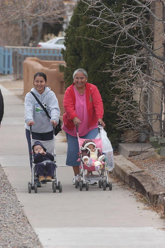 |
Albuquerque8 Originally uploaded by Transportation for America
|
| Streets safe for walking and biking — especially streets that encourage incidental exercise by encouraging walking or biking — can help residents be more healthy, lowering the health care costs associated with obesity and inactivity. |
With Congress directing their attention to the contentious debate over health care reform and how to pay for it, it seems that transportation has been relegated to the back burner. In the meantime, evidence is continuing to mount that transportation investments — what we build and where — have an enormous impact on our health and the financial bottom line of providing health care.
Last week the California Center for Public Health Advocacy (CCPHA) released The Economic Costs of Overweight, Obesity and Physical Inactivity Among California Adults. In a state making national headlines for its current budget crisis, the study found that (in 2006) “overweight, obesity and physical inactivity cost the state $41.2 billion – $21.0 billion for overweight and obesity, and $20.2 billion for physical inactivity.”
An even more shocking recent study found that the already-dangerous effects of air pollution are magnified for pregnant women living near busy roads.
According to this study from a team of researchers from the University of California, Irvine, exposure to traffic-generated air pollution during pregnancy increases the risk of preeclampsia and premature birth. The study examined over 80,000 birth records and found that the risk of the life-threatening condition preeclampsia increased 33% and the risk of premature birth rose 128% in women living closest to congested corridors.
Many other negative health effects from vehicle emissions, congestion and air pollution have already been documented — with low-income and minority populations typically experiencing the most harmful side effects due to where interstates and highways get built.
The CCPHA report on obesity included some concrete policy recommendations for improving public health, a few of which are connected to our transportation spending decisions.
- Locate residential, commercial and office buildings close together so more residents can walk and bike to meet their daily needs
- Build neighborhoods with safe and attractive parks and other places for recreational exercise
- Create transportation corridors that support pedestrians and bicyclists
Including some realistic goals for improving public health in the transportation bill — one of T4 America’s six national transportation objectives for the bill — would be a great place to start. If we’re ever going to truly move away from a prescriptive health care model to a preventative model — saving us billions in health care costs — we’re going to have to address more than just the skyrocketing costs of treating illnesses and diseases — we’re going to have to look upstream and address some of the contributing factors.
Doing so could keep us healthier and save us billions.
With research from Becca Homa
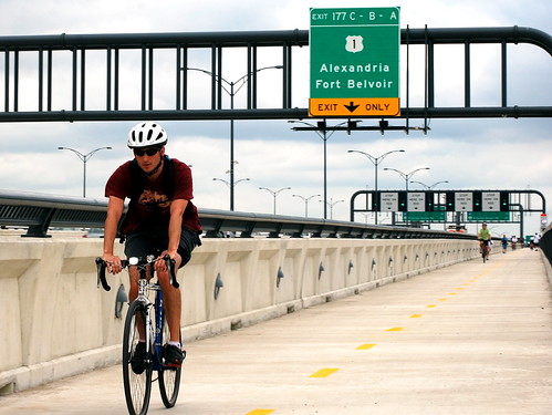 |
A New Trail Originally uploaded by M.V. Jantzen.
A bicyclist cruises along I-495/95 on the new Woodrow Wilson Bridge “active transportation lane,” leading to the rare sight of someone not in a car using the Capital Beltway. View more photos of the opening on Flickr from Eric Gilliland, director of the Washington Area Bicyclist Association (a T4 partner.) |
Two weekends ago, the 12-foot-wide bicycle and pedestrian lane of the Woodrow Wilson interstate bridge over the Potomac River held its grand opening in Washington DC, filling with bikers and walkers who can now join the thousands of cars that cross the bridge each day.
The bridge, which connects Virginia and Maryland on the southern part of the Capital Beltway, is a vital transportation link in the region, where Interstate 95 (and the large majority of truck traffic) bypasses Washington, continuing north or south along the eastern seaboard.
Hundreds of bicyclists enjoyed a ride across the bridge for the first time ever last weekend, and the renovations to the bridge also added dedicated space for a future transit line — not something you see everyday on an interstate bridge in the United States.
Building a new bridge to replace the 1961 bridge had been discussed for decades, but the planning kicked into high gear in the 1990’s, with Maryland, Virginia, and the federal government all engaged in the process (DC relinquished control to the states.)
 |
| The King Street (Virginia) and Branch Avenue (Maryland) Metro stops are separated by just a few miles and the Potomac River, but require a long ride into DC to travel between the two on the Metrorail system. One day, Metro might cross the Wilson Bridge instead. |
Looking at a map of the Metrorail public transportation system, one can see that only a few miles separate the end of the green line in Maryland and the yellow and blue lines in Virginia. There was no active work to connect the two lines, but a handful of people in the planning process wondered about dedicating some space on the bridge for a future, useful Metro connection.
Parris Glendening, Governor of Maryland from 1995-2003, said that planning for a future transit connection was just common sense.
“Those stations are just a few miles apart as the crow flies, but no one in Maryland who has a choice is going to ride all the way up into DC to switch trains and ride all the way back out to Virginia — and end up only a few miles from where they started,” he said. (more…)


