
Does your community have too much parking? Here’s how to find out.

A parking lot hosts three cars and dozens of empty spaces

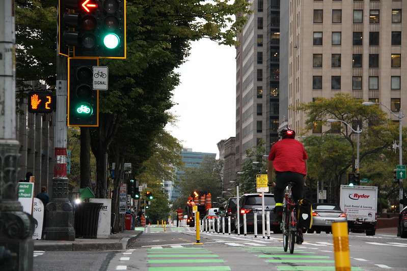
Many communities are either “overparked” (meaning they have too much parking) or are inefficiently allocating their existing parking resources. By understanding how communities’ parking assets are being used and regulated we can ensure that all modes’ access to jobs, services and amenities is supported.

A parking lot hosts three cars and dozens of empty spaces
Nearly empty parking lot in Isabella County, Michigan (Jeffrey Smith, Flickr)

How much parking do we really have?

In Miami, Florida there is a minimum of 1.5 parking spaces required per residential dwelling unit and a minimum of 3 parking spaces required for every 1000 square feet of office or commercial use. These parking requirements are quite common in community zoning codes, the regulatory framework guiding development. As a result, communities across the country now have an oversupply of parking.

Considering the factors above, it is important to be mindful of how we use parking in our communities. Building an understanding of the space available can allow communities to maximize the benefits of having sufficient parking while also ensuring that we help communities identify underutilized parking areas and enable municipalities to allocate space more effectively for various modes of transportation, including sidewalks, bike lanes, public transit, and community activation.

One essential way that parking is regulated today is through parking audits. Parking audits are comprehensive assessments of a city’s parking systems, encompassing facilities, policies, regulations, and management practices. These audits involve supporting strategic management and provision of sufficient parking and curb access around cities, and analysis to gain a deep understanding of a city’s parking resources, utilization patterns, and their impact on transportation and urban development.

How to conduct a parking audit

During a parking audit, people measure how much parking is available in a specific area. The interesting thing is that anybody can do this.

The specifics of your audit will depend on your local context. If your city is considering reducing or removing parking requirements, you might have an opportunity to partner with your local government to conduct parking audits with city staff. If city leaders and officials haven’t yet caught on to the parking dilemma in your area, you can use a parking audit to help advocate for change. In either case, using the audit to build connections with community members, policymakers, and city staff can be a powerful way to develop common ground.

To get started on a parking audit, check out these step-by-step guides from Strong Towns and the Metropolitan Area Planning Council of Boston.

Questions to consider

How long are people staying parked? Occupancy stay refers to how long a parking space is being used by a vehicle. This metric provides insights into the duration of parking sessions, helping planners understand the average duration vehicles remain parked in a specific location.

DDOT parking evaluations include time of day and spot usage on 17th St NW
To understand parking in DC, the District DOT utilized time-lapse photography. (DDOT)

How many times was the parking space used? Occupancy turnover measures how many times a parking space is used within a given period. It provides insights into the rate at which parking spaces become available for new users. High turnover rates indicate efficient use of parking resources, while low turnover may suggest underutilization or improper pricing.

What is the ratio? Occupancy is the ratio of the number of parking spaces in use to the total number of spaces available. It is a fundamental metric for understanding the utilization level of a parking facility at a specific point in time or as an average over the day. The purpose is to provide a snapshot of how full a parking area is and whether there is excess capacity or shortages during peak times.

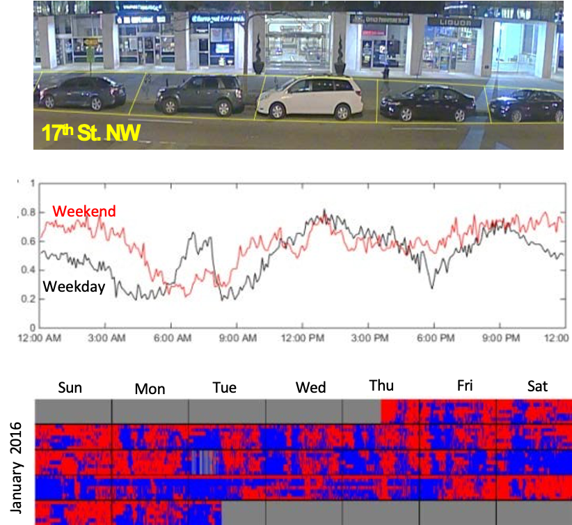
Collecting all this data can take time, but fortunately, there are tools you can use beyond a clipboard, camera, and a stopwatch. To cover more ground, communities like New York City or Washington, DC have deployed time-lapse photography to understand parking and loading demand. To learn more about how to take time-lapse photos, check out this guide from the District Department of Transportation.

By embracing parking audits and utilizing metrics like occupancy stay, turnover, and overall occupancy, communities can enhance accessibility, promote safety, and maximize the utilization of valuable real estate. So, whether you’re strolling, biking, or driving, let’s park smarter and pave the way for a more sustainable and accessible future.

Rethinking the intersection to prioritize safety over speed

A cyclist crosses an intersection with the aid of a green bicycle crossing signal

The rising rate of pedestrian fatalities is a consequence of deadly design decisions that prioritize driver speed and convenience over the safety of all other road users. Today, we dig into one example: crosswalk signals.

A cyclist crosses an intersection with the aid of a green bicycle crossing signal
Flickr photo by Seattle DOT.

As communities work to advance safe streets, they must also ensure that these efforts lead to design changes that effectively integrate with the technology managing traffic flow for all users. Many walk signals are timed based on outdated standards that prioritize maximum green time for all motorized vehicle movements. Signal timing gets reviewed on a case-by-case basis, leveraging a manual last published in 2015 that isn’t supplemented often to consider the diverse needs of pedestrians, such as people with disabilities, seniors, cyclists, or parents with strollers.

Walk signals are just one example of how our infrastructure prioritizes the speed of vehicles over the safety of other road users. This practice comes at a deadly cost.

We are in the midst of a historic and alarming increase in the number of people struck and killed while walking, which has been on a steady rise since 2009, reaching levels not seen in more than 30 years. Speed is the number one culprit in these fatalities. Speed is also the best predictor of whether or not a collision will result in an injury or death. Design elements, including effective traffic signals, are essential to reducing speeds and improving safety.

If not designed correctly, intersections can be one of the most dangerous places where folks in and outside of cars interact. There are many recent examples of places that experience a high number of crashes at crosswalks. Saint Paul, Minnesota is a prime example of this. In 2016, Shelby Kokesch was killed while attempting to cross Kellogg Boulevard, a busy thoroughfare, from the Minnesota History Center. Though Kokesch used a marked crosswalk, it lacked a stop sign or a crossing signal. While one car pulled over to let Kokesch and her mother pass, the second vehicle—an SUV—did not stop.

At the time, Saint Paul responded with higher traffic enforcement around crosswalks, ticketing drivers who failed to stop at marked crosswalks and yield to pedestrians. During the crackdown, Sergeant Jeremy Ellison reflected, “An overwhelming response from people is, ‘I didn’t see them.’ People are not paying attention and they’re driving too fast.”

This is a design problem—and it has a design solution

Signalized intersections draw attention to pedestrian crossings and help ensure that traffic comes to a complete stop before travelers enter the crosswalk. Street design can be more influential on driver behavior than speed limits or enforcement alone. Complete Streets—an approach to designing streets that prioritizes the safety and comfort of people who walk, bike, and roll—can lead to slower driver speeds, reducing the risk of crashes and roadway fatalities for folks both in and outside of cars.

Designing an intersection with safety in mind can take a lot of different forms, such as shortening the length of an intersection by reducing the number of vehicle lanes—or by ensuring appropriate time to cross the street. Walk signals and walk signal timing also play an important role by giving pedestrians adequate time to cross. For example, leading pedestrian intervals allow pedestrians to begin crossing the street before cars turn right or left, signaling to drivers that pedestrians are present and making it easier for them to see and yield to other people using the road.

One aspect of a Complete Streets approach is practicing effective community engagement. Administering walk audits with a variety of road users, community residents, and decision makers can assist municipal planners in determining whether a signal offers enough time to cross the street. By implementing this approach, planners and engineers can experience a street in the same way as the people who travel on it every day. Using this method can allow cities and states to make their streets safer and more accessible.

Pedestrian fatalities will continue to rise until we prioritize the safety of all road users over the speed of a few. The effective use of crosswalk signals, combined with other elements of safe street design, can reduce the danger on our roadways and ensure that everyone can safely get to where they need to go. Learn more about a Complete Streets approach here.