A day of air travel over North America, and what it means for rail
From Wired Magazine via Aaron of Streetsblog comes this amazing map and video that shows a day of air travel over North America. Using data from the Federal Aviation Administration and a service called FlightView that tracks airline travel each day, artist Aaron Koblin created this Google map that shows 24 hours of airline travel on August 12, 2008.
There’s also a breathtaking movie version of this same map, that shows the flights in real time through the course of the day.
The sheer number of airplanes traveling over the United States is simply mind boggling. On this day chronicled in the map, the FAA tracked 205,000 flights in U.S. airspace. Anyone who has ever traveled by plane knows that we have plenty of air above our country, but the problem is the fact that too many of them need to be in specific pieces of air at the same time. Or traveling through the same crowded airports.
Watch the movie and look at what happens to the east coast — especially the northeastern corridor — during the major commuting hours. Our major airports are bursting at the seams, and our air traffic control system, while among the safest and most professional in the world, is hard pressed to keep up with the growing demands placed on it.
With some experts predicting a doubling of airline traffic by 2050 — though not considering the impact that fuel prices or economic conditions could have on the industry — we’d be smart to find a way to get some of these planes out of the air.
What if there was a way to remove as much as a third of these planes from the air. Or even just a 1/4 or 1/5? Imagine the difference in our most crowded metropolitan airports (and travelers) if we could ease the burden on their runways and air traffic control systems?
Q: What could we do to make air travel simpler, faster, and more cost effective?
A: Build a robust nationwide network of passenger rail once again to take the pressure off of the airlines and our airspace. Use airline travel for longer trips where it makes the most financial sense. Start with the heavily trafficked shorter city-to-city corridors that are responsible for a huge portion of air travel.
Did you know that 1/3 of all air travel in this country is for trips under 350 miles? Think of heavily traveled corridors like Atlanta to Charlotte, Washington DC to New York, Houston to Dallas, San Francisco to Los Angeles. These are all trips near or under 350 miles.
Imagine the impact that having efficient city to city rail options in heavily traveled corridors would have on air travel in this country — not to mention what it would do for boosting our economic competitiveness, reducing emissions, and improving energy security with an electrified system that isn’t beholden to the price of oil.
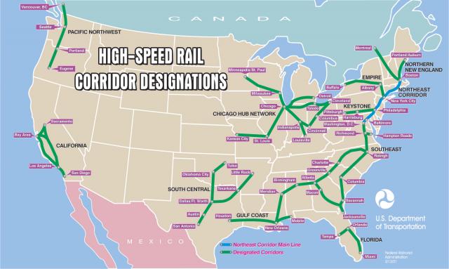
Compare this 2001 map from the U.S. Department of Transportation establishing potential high speed rail corridors to the portions of heaviest air travel on Koblin’s map above.
High speed rail across the country is obviously something we’d love to see. But a great start would be improving existing passenger rail in these corridors to make it reliable, faster and on-time. The Northeast corridor is the only place where trains don’t have to regularly submit to freight trains, but service is still constrained by obstacles like old trackage, curves in the route, old bridges and tunnels, just to name a few. The distance from Washington to Charlotte’s financial markets is shorter than DC to Boston through the bustling Northeast megaregion, but the trip is hours longer due to freight priority and other constraints.
Dedicated right-of-way for passenger rail could make train travel feasible once again, improve freight times with passenger trains out of their way, and ease up airport congestion. What’s not to like?
So what do you think? What should we do to improve rail service in the United States?


